Los Saucos elevation
Los Saucos (State of Mexico, Valle de Bravo), Mexico elevation is 2549 meters and Los Saucos elevation in feet is 8363 ft above sea level [src 1]. Los Saucos is a populated place (feature code) with elevation that is 1235 meters (4052 ft) bigger than average city elevation in Mexico.
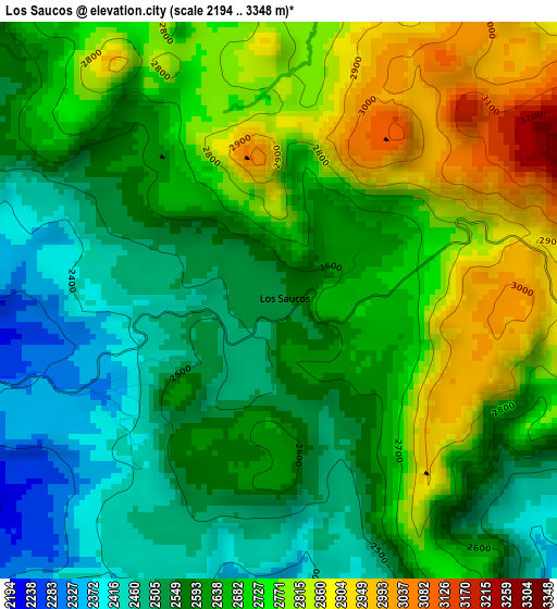
Below is the Elevation map of Los Saucos, which displays elevation range with different colors. Scale of the first map is from 2194 to 3348 m (7198 to 10984 ft) with average elevation of 2652.1 meters (=8701 ft) [note 1]
These maps also provides idea of topography and contour of this city, they are displayed at different zoom levels. More info about maps, scale and edge coordinates you can find below images.
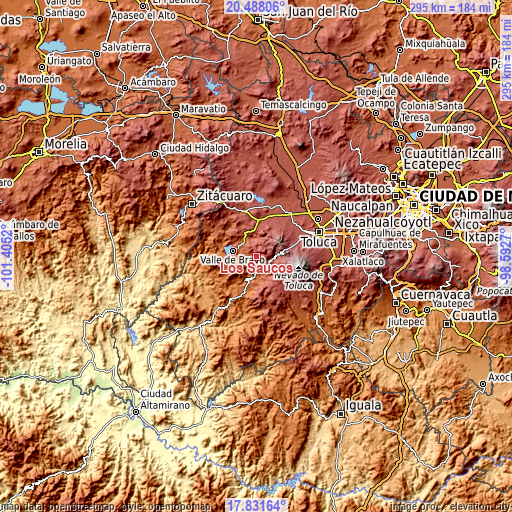
| \ | Map #1 | Topo.Map |
| Scale [m] | 2194..3348 m | × |
| Scale [ft] | 7198..10984 ft | × |
| Average | 2652.1 m = 8701 ft | × |
| Width | 9.23 km = 5.7 mi | 295.4 km = 183.6 mi |
| Height | 9.23 km = 5.7 mi | 295.4 km = 183.6 mi |
| ↑Max Latitude | 19.206704° | 20.48806° |
| Latitude at center | 19.1652° | 19.1652° |
| ↓Min Latitude | 19.123685° | 17.83164° |
| ← Min Longitude | -100.042895° | -101.4052° |
| Longitude center | -99.99895° | -99.99895° |
| →Max Longitude | -99.955005° | -98.5927° |
Nearby cities:
Cities around Los Saucos sort by population:
• San Juan elevation 2333 m
9.7 km,  339°
339°
• San Jerónimo 2459 m
8.9 km, 344°
• San Bartolo 2276 m
10.5 km,  327°
327°
• San Mateo Almomoloha 2598 m
7.1 km,  107°
107°
• San Lucas del Pulque 2169 m
7.7 km,  203°
203°
• San Francisco Oxtotilpan 2642 m
10.1 km,  87°
87°
• Amanalco de Becerra 2339 m
10.1 km,  347°
347°
• San Miguel Oxtotilpan 2743 m
11.1 km,  102°
102°
• Cuadrilla de Dolores 2192 m
7.9 km,  249°
249°
• San Lucas 2381 m
10.5 km,  355°
355°
• La Compañía 2103 m
8.5 km,  269°
269°
• Casas Viejas 2053 m
11.5 km,  262°
262°
Multilingual:
 En español:
Los Saucos elevación 2549 m.
 En France:
Los Saucos élévation 2549 m.
 Auf Deutsch:
Los Saucos höhe über dem Meeresspiegel ist 2549 m.

Sources and notes:
- [note 1] Map square and city borders are not equal. Map elevation data is calculated only from area inside that square.
- [src 1] Elevation data from geonames database provided with same terms of usage.
- [src 2] The elevation map of Los Saucos is generated using elevation data from NASA's 3 arcsec (90m) resolution SRTM data.
- [src 3] Base (background) map © OpenStreetMap contributors tiles are generated by Geofabrik and OpenTopoMap.
Copyright & License:
This Los Saucos Elevation Map is licensed under CC BY-SA. You may reuse any part from this page, if you give a proper credit by linking to this URL:
 More info on terms of use page.