Tlalconteno elevation
Tlalconteno (Veracruz, Ayahualulco), Mexico elevation is 2724 meters and Tlalconteno elevation in feet is 8937 ft above sea level [src 1]. Tlalconteno is a populated place (feature code) with elevation that is 1410 meters (4626 ft) bigger than average city elevation in Mexico.
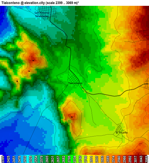
Below is the Elevation map of Tlalconteno, which displays elevation range with different colors. Scale of the first map is from 2399 to 3069 m (7871 to 10069 ft) with average elevation of 2698 meters (=8852 ft) [note 1]
These maps also provides idea of topography and contour of this city, they are displayed at different zoom levels. More info about maps, scale and edge coordinates you can find below images.
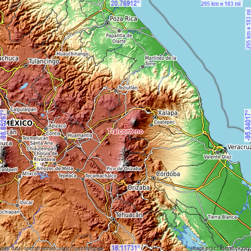
| \ | Map #1 | Topo.Map |
| Scale [m] | 2399..3069 m | × |
| Scale [ft] | 7871..10069 ft | × |
| Average | 2698 m = 8852 ft | × |
| Width | 9.21 km = 5.7 mi | 294.9 km = 183.2 mi |
| Height | 9.21 km = 5.7 mi | 294.9 km = 183.2 mi |
| ↑Max Latitude | 19.490063° | 20.76912° |
| Latitude at center | 19.44863° | 19.44863° |
| ↓Min Latitude | 19.407187° | 18.11731° |
| ← Min Longitude | -97.290365° | -98.65267° |
| Longitude center | -97.24642° | -97.24642° |
| →Max Longitude | -97.202475° | -95.84017° |
Nearby cities:
Cities around Tlalconteno sort by population:
• Perote elevation 2416 m
12.6 km,  1°
1°
• Los Altos 2888 m
4.6 km,  93°
93°
• La Gloria 2459 m
7 km,  212°
212°
• Francisco I. Madero 2446 m
9.1 km,  343°
343°
• González Ortega 2847 m
12 km,  191°
191°
• El Triunfo 2767 m
4.1 km,  137°
137°
• Xocotepéc 2373 m
12 km, 138°
• Apantéopan 2444 m
11.6 km,  149°
149°
• Tonalaco 2645 m
12.1 km,  100°
100°
• El Escobillo 3046 m
8.9 km,  34°
34°
• La Toma 3026 m
5.6 km, 85°
• Guadalupe Victoria 2406 m
10.9 km, 342°
Multilingual:
 En español:
Tlalconteno elevación 2724 m.
 En France:
Tlalconteno élévation 2724 m.
 Auf Deutsch:
Tlalconteno höhe über dem Meeresspiegel ist 2724 m.

Sources and notes:
- [note 1] Map square and city borders are not equal. Map elevation data is calculated only from area inside that square.
- [src 1] Elevation data from geonames database provided with same terms of usage.
- [src 2] The elevation map of Tlalconteno is generated using elevation data from NASA's 3 arcsec (90m) resolution SRTM data.
- [src 3] Base (background) map © OpenStreetMap contributors tiles are generated by Geofabrik and OpenTopoMap.
Copyright & License:
This Tlalconteno Elevation Map is licensed under CC BY-SA. You may reuse any part from this page, if you give a proper credit by linking to this URL:
 More info on terms of use page.