El Escobillo elevation
El Escobillo (Veracruz, Perote), Mexico elevation is 3046 meters and El Escobillo elevation in feet is 9993 ft above sea level [src 1]. El Escobillo is a populated place (feature code) with elevation that is 1732 meters (5682 ft) bigger than average city elevation in Mexico.
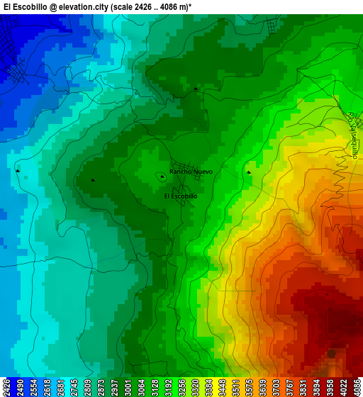
Below is the Elevation map of El Escobillo, which displays elevation range with different colors. Scale of the first map is from 2426 to 4086 m (7959 to 13406 ft) with average elevation of 3084.7 meters (=10120 ft) [note 1]
These maps also provides idea of topography and contour of this city, they are displayed at different zoom levels. More info about maps, scale and edge coordinates you can find below images.
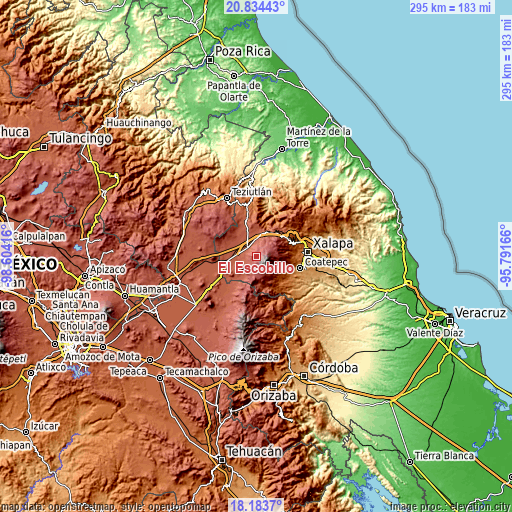
| \ | Map #1 | Topo.Map |
| Scale [m] | 2426..4086 m | × |
| Scale [ft] | 7959..13406 ft | × |
| Average | 3084.7 m = 10120 ft | × |
| Width | 9.21 km = 5.7 mi | 294.7 km = 183.1 mi |
| Height | 9.21 km = 5.7 mi | 294.8 km = 183.2 mi |
| ↑Max Latitude | 19.555916° | 20.83443° |
| Latitude at center | 19.5145° | 19.5145° |
| ↓Min Latitude | 19.473074° | 18.1837° |
| ← Min Longitude | -97.241855° | -98.60416° |
| Longitude center | -97.19791° | -97.19791° |
| →Max Longitude | -97.153965° | -95.79166° |
Nearby cities:
Cities around El Escobillo sort by population:
• Perote elevation 2416 m
7.1 km,  318°
318°
• Los Altos 2888 m
7.6 km,  183°
183°
• Los Molinos 2428 m
9.2 km,  348°
348°
• Francisco I. Madero 2446 m
7.8 km,  280°
280°
• Sierra de Agua 2419 m
10.1 km,  358°
358°
• El Triunfo 2767 m
10.6 km,  192°
192°
• Los Pescados 2988 m
7.3 km,  44°
44°
• Tlalconteno 2724 m
8.9 km,  214°
214°
• Tonalaco 2645 m
11.7 km,  144°
144°
• La Toma 3026 m
6.9 km, 176°
• El Conejo 3257 m
5 km,  67°
67°
• Guadalupe Victoria 2406 m
8.9 km,  289°
289°
Multilingual:
 En español:
El Escobillo elevación 3046 m.
 En France:
El Escobillo élévation 3046 m.
 Auf Deutsch:
El Escobillo höhe über dem Meeresspiegel ist 3046 m.

Sources and notes:
- [note 1] Map square and city borders are not equal. Map elevation data is calculated only from area inside that square.
- [src 1] Elevation data from geonames database provided with same terms of usage.
- [src 2] The elevation map of El Escobillo is generated using elevation data from NASA's 3 arcsec (90m) resolution SRTM data.
- [src 3] Base (background) map © OpenStreetMap contributors tiles are generated by Geofabrik and OpenTopoMap.
Copyright & License:
This El Escobillo Elevation Map is licensed under CC BY-SA. You may reuse any part from this page, if you give a proper credit by linking to this URL:
 More info on terms of use page.