Apantéopan elevation
Apantéopan (Puebla), Mexico elevation is 2444 meters and Apantéopan elevation in feet is 8018 ft above sea level [src 1]. Apantéopan is a populated place (feature code) with elevation that is 1130 meters (3707 ft) bigger than average city elevation in Mexico.
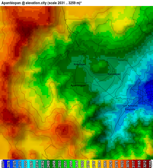
Below is the Elevation map of Apantéopan, which displays elevation range with different colors. Scale of the first map is from 2031 to 3259 m (6663 to 10692 ft) with average elevation of 2655.3 meters (=8712 ft) [note 1]
These maps also provides idea of topography and contour of this city, they are displayed at different zoom levels. More info about maps, scale and edge coordinates you can find below images.
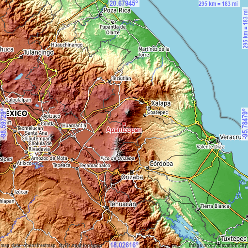
| \ | Map #1 | Topo.Map |
| Scale [m] | 2031..3259 m | × |
| Scale [ft] | 6663..10692 ft | × |
| Average | 2655.3 m = 8712 ft | × |
| Width | 9.22 km = 5.7 mi | 295 km = 183.3 mi |
| Height | 9.22 km = 5.7 mi | 295 km = 183.3 mi |
| ↑Max Latitude | 19.399656° | 20.67945° |
| Latitude at center | 19.3582° | 19.3582° |
| ↓Min Latitude | 19.316734° | 18.02616° |
| ← Min Longitude | -97.234985° | -98.59729° |
| Longitude center | -97.19104° | -97.19104° |
| →Max Longitude | -97.147095° | -95.78479° |
Nearby cities:
Cities around Apantéopan sort by population:
• Los Altos elevation 2888 m
9.9 km,  353°
353°
• Ayahualulco 2055 m
4.5 km,  100°
100°
• Ixhuacán de los Reyes 1806 m
7.7 km,  92°
92°
• La Gloria 2459 m
10.5 km,  293°
293°
• González Ortega 2847 m
8.5 km,  258°
258°
• El Triunfo 2767 m
7.7 km,  336°
336°
• Xocotepéc 2373 m
2.4 km,  63°
63°
• San Antonio Xoquitla 2179 m
3.4 km,  125°
125°
• Tonalaco 2645 m
10 km,  37°
37°
• San Antonio 2401 m
9.8 km,  177°
177°
• La Toma 3026 m
10.5 km,  358°
358°
• Ignacio Zaragoza 2594 m
8.9 km,  185°
185°
Multilingual:
 En español:
Apantéopan elevación 2444 m.
 En France:
Apantéopan élévation 2444 m.
 Auf Deutsch:
Apantéopan höhe über dem Meeresspiegel ist 2444 m.

Sources and notes:
- [note 1] Map square and city borders are not equal. Map elevation data is calculated only from area inside that square.
- [src 1] Elevation data from geonames database provided with same terms of usage.
- [src 2] The elevation map of Apantéopan is generated using elevation data from NASA's 3 arcsec (90m) resolution SRTM data.
- [src 3] Base (background) map © OpenStreetMap contributors tiles are generated by Geofabrik and OpenTopoMap.
Copyright & License:
This Apantéopan Elevation Map is licensed under CC BY-SA. You may reuse any part from this page, if you give a proper credit by linking to this URL:
 More info on terms of use page.