Zoh-Laguna elevation
Zoh-Laguna (Campeche, Calakmul), Mexico elevation is 275 meters and Zoh-Laguna elevation in feet is 902 ft above sea level [src 1]. Zoh-Laguna is a populated place (feature code) with elevation that is 1039 meters (3409 ft) smaller than average city elevation in Mexico.
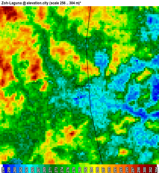
Below is the Elevation map of Zoh-Laguna, which displays elevation range with different colors. Scale of the first map is from 256 to 304 m (840 to 997 ft) with average elevation of 275.6 meters (=904 ft) [note 1]
These maps also provides idea of topography and contour of this city, they are displayed at different zoom levels. More info about maps, scale and edge coordinates you can find below images.
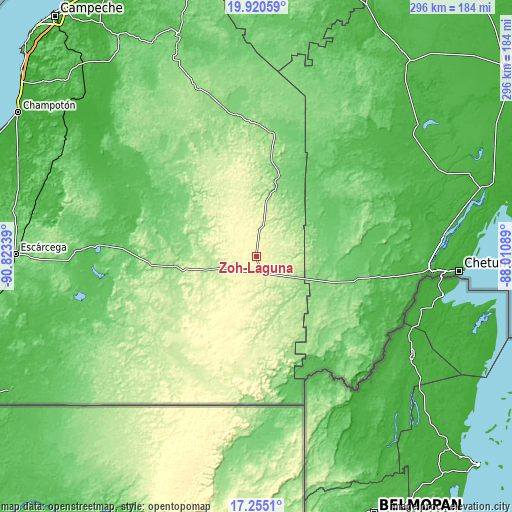
| \ | Map #1 | Topo.Map |
| Scale [m] | 256..304 m | × |
| Scale [ft] | 840..997 ft | × |
| Average | 275.6 m = 904 ft | × |
| Width | 9.26 km = 5.8 mi | 296.4 km = 184.2 mi |
| Height | 9.26 km = 5.8 mi | 296.4 km = 184.2 mi |
| ↑Max Latitude | 18.634707° | 19.92059° |
| Latitude at center | 18.59306° | 18.59306° |
| ↓Min Latitude | 18.551403° | 17.2551° |
| ← Min Longitude | -89.461085° | -90.82339° |
| Longitude center | -89.41714° | -89.41714° |
| →Max Longitude | -89.373195° | -88.01089° |
Nearby cities:
Cities around Zoh-Laguna sort by population:
• Nicolás Bravo elevation 100 m
53.7 km,  106°
106°
• Xpujil 248 m
9.8 km,  165°
165°
• Javier Rojo Gómez 47 m
85.4 km, 114°
• Álvaro Obregón 34 m
87.1 km, 112°
• Cacao 54 m
88.1 km,  120°
120°
• Ukúm 131 m
72.7 km,  6°
6°
• Caobas 130 m
36.8 km, 116°
• Morocoy 73 m
63.9 km,  88°
88°
• Xmabén 132 m
72.2 km, 8°
• Constitución 84 m
75.8 km,  272°
272°
• Chunchintok 142 m
87.2 km,  348°
348°
• Altamira de Zináparo 122 m
88.4 km, 269°
Multilingual:
 En español:
Zoh-Laguna, Álvaro Obregón, Zoh Laguna elevación 275 m.
 En France:
Zoh-Laguna élévation 275 m.
 Auf Deutsch:
Zoh-Laguna höhe über dem Meeresspiegel ist 275 m.

Sources and notes:
- [note 1] Map square and city borders are not equal. Map elevation data is calculated only from area inside that square.
- [src 1] Elevation data from geonames database provided with same terms of usage.
- [src 2] The elevation map of Zoh-Laguna is generated using elevation data from NASA's 3 arcsec (90m) resolution SRTM data.
- [src 3] Base (background) map © OpenStreetMap contributors tiles are generated by Geofabrik and OpenTopoMap.
Copyright & License:
This Zoh-Laguna Elevation Map is licensed under CC BY-SA. You may reuse any part from this page, if you give a proper credit by linking to this URL:
 More info on terms of use page.