Nicolás Bravo elevation
Nicolás Bravo (Quintana Roo, Othón P. Blanco), Mexico elevation is 100 meters and Nicolás Bravo elevation in feet is 328 ft above sea level [src 1]. Nicolás Bravo is a populated place (feature code) with elevation that is 1214 meters (3983 ft) smaller than average city elevation in Mexico.
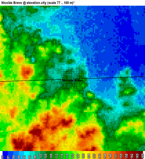
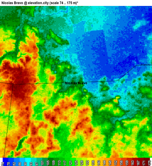
Below is the Elevation map of Nicolás Bravo, which displays elevation range with different colors. Scale of the first map is from 77 to 169 m (253 to 554 ft) with average elevation of 108.5 meters (=356 ft) [note 1]
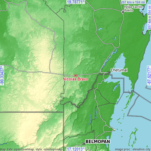
These maps also provides idea of topography and contour of this city, they are displayed at different zoom levels. More info about maps, scale and edge coordinates you can find below images.
| \ | Map #1 | Map #2 | Topo.Map |
| Scale [m] | 77..169 m | 74..175 m | × |
| Scale [ft] | 253..554 ft | 243..574 ft | × |
| Average | 108.5 m = 356 ft | 114.4 m = 375 ft | × |
| Width | 9.27 km = 5.8 mi | 18.54 km = 11.5 mi | 296.6 km = 184.3 mi |
| Height | 9.27 km = 5.8 mi | 18.54 km = 11.5 mi | 296.6 km = 184.3 mi |
| ↑Max Latitude | 18.500779° | 18.542448° | 19.78771° |
| Latitude at center | 18.4591° | 18.4591° | 18.4591° |
| ↓Min Latitude | 18.417411° | 18.375711° | 17.12013° |
| ← Min Longitude | -88.971965° | -89.015911° | -90.33427° |
| Longitude center | -88.92802° | -88.92802° | -88.92802° |
| →Max Longitude | -88.884075° | -88.840129° | -87.52177° |
Nearby cities:
Cities around Nicolás Bravo sort by population:
• Javier Rojo Gómez elevation 47 m
33.2 km,  128°
128°
• Álvaro Obregón 34 m
34.2 km,  121°
121°
• Sergio Butrón Casas 38 m
38.4 km,  80°
80°
• Cacao 54 m
38.3 km,  140°
140°
• Pucté 38 m
37.3 km, 132°
• Carlos A. Madrazo 26 m
42.8 km, 83°
• Ucum 29 m
43.5 km, 83°
• Caobas 130 m
18.7 km,  265°
265°
• Sabidos 55 m
37.7 km,  107°
107°
• Morocoy 73 m
20.2 km,  37°
37°
• Jose Narciso Rovirosa 44 m
44.7 km,  151°
151°
• Cocoyol 41 m
41.2 km, 142°
Multilingual:
 En español:
Nicolás Bravo elevación 100 m.
 En France:
Nicolás Bravo élévation 100 m.
 Auf Deutsch:
Nicolás Bravo höhe über dem Meeresspiegel ist 100 m.

Sources and notes:
- [note 1] Map square and city borders are not equal. Map elevation data is calculated only from area inside that square.
- [src 1] Elevation data from geonames database provided with same terms of usage.
- [src 2] The elevation map of Nicolás Bravo is generated using elevation data from NASA's 3 arcsec (90m) resolution SRTM data.
- [src 3] Base (background) map © OpenStreetMap contributors tiles are generated by Geofabrik and OpenTopoMap.
Copyright & License:
This Nicolás Bravo Elevation Map is licensed under CC BY-SA. You may reuse any part from this page, if you give a proper credit by linking to this URL:
 More info on terms of use page.