Constitución elevation
Constitución (Campeche, Calakmul), Mexico elevation is 84 meters and Constitución elevation in feet is 276 ft above sea level [src 1]. Constitución is a populated place (feature code) with elevation that is 1230 meters (4035 ft) smaller than average city elevation in Mexico.
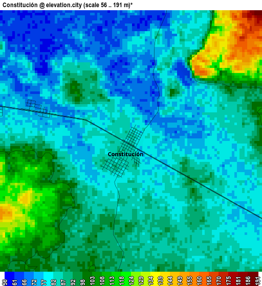
Below is the Elevation map of Constitución, which displays elevation range with different colors. Scale of the first map is from 56 to 191 m (184 to 627 ft) with average elevation of 87.3 meters (=286 ft) [note 1]
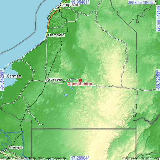
These maps also provides idea of topography and contour of this city, they are displayed at different zoom levels. More info about maps, scale and edge coordinates you can find below images.
| \ | Map #1 | Topo.Map |
| Scale [m] | 56..191 m | × |
| Scale [ft] | 184..627 ft | × |
| Average | 87.3 m = 286 ft | × |
| Width | 9.26 km = 5.8 mi | 296.3 km = 184.1 mi |
| Height | 9.26 km = 5.8 mi | 296.3 km = 184.1 mi |
| ↑Max Latitude | 18.668388° | 19.95401° |
| Latitude at center | 18.62675° | 18.62675° |
| ↓Min Latitude | 18.585101° | 17.28904° |
| ← Min Longitude | -90.179785° | -91.54209° |
| Longitude center | -90.13584° | -90.13584° |
| →Max Longitude | -90.091895° | -88.72959° |
Nearby cities:
Cities around Constitución sort by population:
• Escárcega elevation 83 m
64.3 km,  268°
268°
• Xpujil 248 m
79.3 km,  99°
99°
• División del Norte 101 m
67.1 km,  260°
260°
• Carrillo Puerto 64 m
66 km,  321°
321°
• Xbacab 21 m
70.9 km,  299°
299°
• La Libertad 93 m
40.3 km, 261°
• Matamoros 108 m
54 km, 264°
• Maya Tecún I 70 m
70.3 km,  326°
326°
• Haro 69 m
72 km,  253°
253°
• Don Samuel 88 m
81.6 km, 248°
• Zoh-Laguna 275 m
75.8 km,  92°
92°
• Altamira de Zináparo 122 m
13.6 km, 248°
Multilingual:
 En español:
Constitución elevación 84 m.
 En France:
Constitución élévation 84 m.
 Auf Deutsch:
Constitución höhe über dem Meeresspiegel ist 84 m.

Sources and notes:
- [note 1] Map square and city borders are not equal. Map elevation data is calculated only from area inside that square.
- [src 1] Elevation data from geonames database provided with same terms of usage.
- [src 2] The elevation map of Constitución is generated using elevation data from NASA's 3 arcsec (90m) resolution SRTM data.
- [src 3] Base (background) map © OpenStreetMap contributors tiles are generated by Geofabrik and OpenTopoMap.
Copyright & License:
This Constitución Elevation Map is licensed under CC BY-SA. You may reuse any part from this page, if you give a proper credit by linking to this URL:
 More info on terms of use page.