Xochitepec elevation
Xochitepec (Puebla, Jolalpan), Mexico elevation is 1382 meters and Xochitepec elevation in feet is 4534 ft above sea level [src 1]. Xochitepec is a populated place (feature code) with elevation that is 68 meters (223 ft) bigger than average city elevation in Mexico.
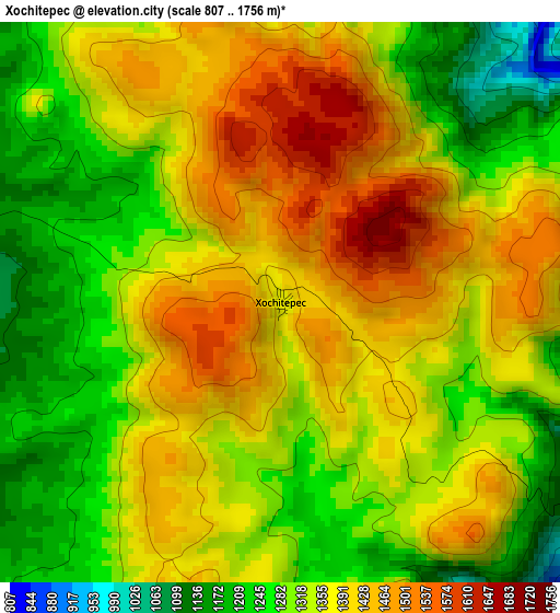
Below is the Elevation map of Xochitepec, which displays elevation range with different colors. Scale of the first map is from 807 to 1756 m (2648 to 5761 ft) with average elevation of 1348.1 meters (=4423 ft) [note 1]
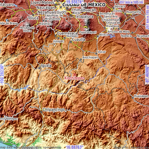
These maps also provides idea of topography and contour of this city, they are displayed at different zoom levels. More info about maps, scale and edge coordinates you can find below images.
| \ | Map #1 | Topo.Map |
| Scale [m] | 807..1756 m | × |
| Scale [ft] | 2648..5761 ft | × |
| Average | 1348.1 m = 4423 ft | × |
| Width | 9.28 km = 5.8 mi | 297 km = 184.5 mi |
| Height | 9.28 km = 5.8 mi | 297 km = 184.5 mi |
| ↑Max Latitude | 18.270065° | 19.55878° |
| Latitude at center | 18.22833° | 18.22833° |
| ↓Min Latitude | 18.186585° | 16.88763° |
| ← Min Longitude | -98.920055° | -100.28236° |
| Longitude center | -98.87611° | -98.87611° |
| →Max Longitude | -98.832165° | -97.46986° |
Nearby cities:
Cities around Xochitepec sort by population:
• Chiautla de Tapia elevation 1022 m
29.9 km,  74°
74°
• Ciudad de Chiautla de Tapia 1019 m
29.8 km, 74°
• Jolalpan 883 m
11.2 km,  17°
17°
• Copalillo 886 m
27.7 km,  218°
218°
• Huehuetlan el Chico 964 m
25.4 km,  50°
50°
• Tlancualpican 987 m
29.4 km,  39°
39°
• Tzicatlán 991 m
27.8 km,  27°
27°
• Atenango del Río 635 m
28 km,  240°
240°
• Teotlalco 1023 m
28.7 km, 21°
• Huachinantla 867 m
11.4 km,  301°
301°
• Ixcamilpa 720 m
29.3 km,  139°
139°
• Chaucingo 838 m
26.5 km,  287°
287°
Multilingual:
 En español:
Xochitepec elevación 1382 m.
 En France:
Xochitepec élévation 1382 m.
 Auf Deutsch:
Xochitepec höhe über dem Meeresspiegel ist 1382 m.

Sources and notes:
- [note 1] Map square and city borders are not equal. Map elevation data is calculated only from area inside that square.
- [src 1] Elevation data from geonames database provided with same terms of usage.
- [src 2] The elevation map of Xochitepec is generated using elevation data from NASA's 3 arcsec (90m) resolution SRTM data.
- [src 3] Base (background) map © OpenStreetMap contributors tiles are generated by Geofabrik and OpenTopoMap.
Copyright & License:
This Xochitepec Elevation Map is licensed under CC BY-SA. You may reuse any part from this page, if you give a proper credit by linking to this URL:
 More info on terms of use page.