Huehuetlan el Chico elevation
Huehuetlan el Chico (Puebla, Huehuetlán el Chico), Mexico elevation is 964 meters and Huehuetlan el Chico elevation in feet is 3163 ft above sea level [src 1]. Huehuetlan el Chico is a seat of a second-order administrative division (feature code) with elevation that is 350 meters (1148 ft) smaller than average city elevation in Mexico.
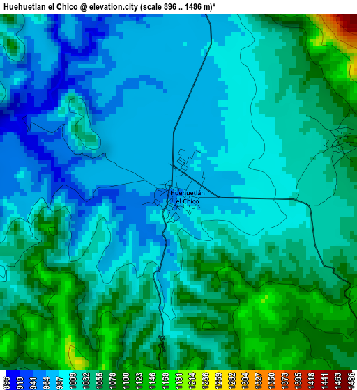
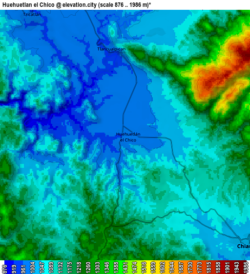
Below is the Elevation map of Huehuetlan el Chico, which displays elevation range with different colors. Scale of the first map is from 896 to 1486 m (2940 to 4875 ft) with average elevation of 1027.1 meters (=3370 ft) [note 1]
These maps also provides idea of topography and contour of this city, they are displayed at different zoom levels. More info about maps, scale and edge coordinates you can find below images.
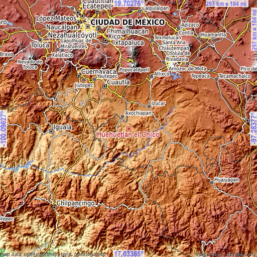
| \ | Map #1 | Map #2 | Topo.Map |
| Scale [m] | 896..1486 m | 876..1986 m | × |
| Scale [ft] | 2940..4875 ft | 2874..6516 ft | × |
| Average | 1027.1 m = 3370 ft | 1112.5 m = 3650 ft | × |
| Width | 9.27 km = 5.8 mi | 18.55 km = 11.5 mi | 296.8 km = 184.4 mi |
| Height | 9.27 km = 5.8 mi | 18.55 km = 11.5 mi | 296.8 km = 184.4 mi |
| ↑Max Latitude | 18.41517° | 18.45686° | 19.70276° |
| Latitude at center | 18.37347° | 18.37347° | 18.37347° |
| ↓Min Latitude | 18.33176° | 18.29004° | 17.03385° |
| ← Min Longitude | -98.733965° | -98.777911° | -100.09627° |
| Longitude center | -98.69002° | -98.69002° | -98.69002° |
| →Max Longitude | -98.646075° | -98.602129° | -97.28377° |
Nearby cities:
Cities around Huehuetlan el Chico sort by population:
• Axochiapan elevation 1039 m
15.8 km,  334°
334°
• Chiautla de Tapia 1022 m
12.2 km,  131°
131°
• Atencingo 1096 m
17.9 km,  29°
29°
• Ciudad de Chiautla de Tapia 1019 m
12.2 km, 131°
• Jolalpan 883 m
17.2 km,  251°
251°
• Chietla 1132 m
20.1 km,  35°
35°
• Tlancualpican 987 m
6.7 km,  351°
351°
• Atlacahualoya 1056 m
19 km, 347°
• Tzicatlán 991 m
11 km,  321°
321°
• Quebrantadero 1065 m
19.8 km, 327°
• Teotlalco 1023 m
14.1 km, 318°
• Buenavista de Benito Juárez 1060 m
11.1 km, 29°
Multilingual:
 En español:
Huehuetlan el Chico elevación 964 m.
 En France:
Huehuetlan el Chico élévation 964 m.
 Auf Deutsch:
Huehuetlan el Chico höhe über dem Meeresspiegel ist 964 m.
 На русском:
Huehuetlan el Chico высота над уровнем моря 964 м
Sources and notes:
- [note 1] Map square and city borders are not equal. Map elevation data is calculated only from area inside that square.
- [src 1] Elevation data from geonames database provided with same terms of usage.
- [src 2] The elevation map of Huehuetlan el Chico is generated using elevation data from NASA's 3 arcsec (90m) resolution SRTM data.
- [src 3] Base (background) map © OpenStreetMap contributors tiles are generated by Geofabrik and OpenTopoMap.
Copyright & License:
This Huehuetlan el Chico Elevation Map is licensed under CC BY-SA. You may reuse any part from this page, if you give a proper credit by linking to this URL:
 More info on terms of use page.