Axochiapan elevation
Axochiapan (Morelos), Mexico elevation is 1039 meters and Axochiapan elevation in feet is 3409 ft above sea level [src 1]. Axochiapan is a seat of a second-order administrative division (feature code) with elevation that is 275 meters (902 ft) smaller than average city elevation in Mexico.
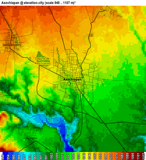
Below is the Elevation map of Axochiapan, which displays elevation range with different colors. Scale of the first map is from 948 to 1107 m (3110 to 3632 ft) with average elevation of 1031.8 meters (=3385 ft) [note 1]
These maps also provides idea of topography and contour of this city, they are displayed at different zoom levels. More info about maps, scale and edge coordinates you can find below images.
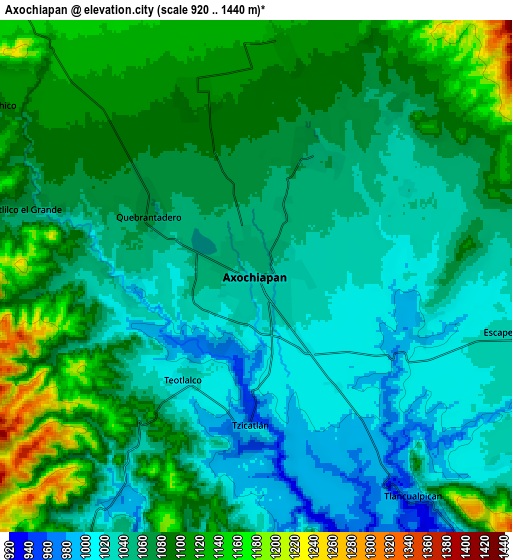
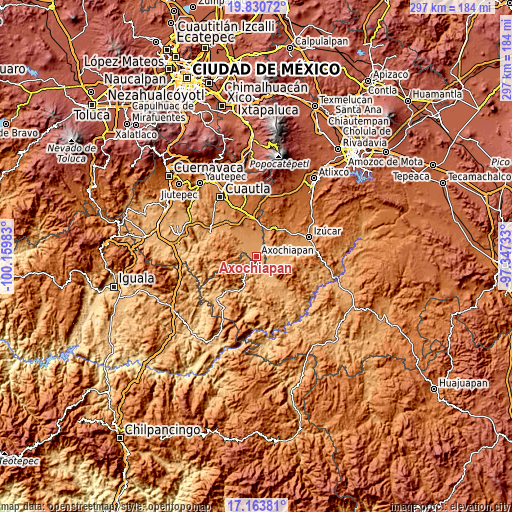
| \ | Map #1 | Map #2 | Topo.Map |
| Scale [m] | 948..1107 m | 920..1440 m | × |
| Scale [ft] | 3110..3632 ft | 3018..4724 ft | × |
| Average | 1031.8 m = 3385 ft | 1067.5 m = 3502 ft | × |
| Width | 9.27 km = 5.8 mi | 18.53 km = 11.5 mi | 296.5 km = 184.2 mi |
| Height | 9.27 km = 5.8 mi | 18.53 km = 11.5 mi | 296.6 km = 184.3 mi |
| ↑Max Latitude | 18.544129° | 18.585787° | 19.83072° |
| Latitude at center | 18.50246° | 18.50246° | 18.50246° |
| ↓Min Latitude | 18.460781° | 18.419092° | 17.16381° |
| ← Min Longitude | -98.797525° | -98.841471° | -100.15983° |
| Longitude center | -98.75358° | -98.75358° | -98.75358° |
| →Max Longitude | -98.709635° | -98.665689° | -97.34733° |
Nearby cities:
Cities around Axochiapan sort by population:
• Tepalcingo elevation 1166 m
14.1 km,  316°
316°
• Telixtac 1104 m
6.9 km,  339°
339°
• Tlancualpican 987 m
9.5 km,  143°
143°
• Atlacahualoya 1056 m
4.9 km,  30°
30°
• Tetelilla 1184 m
12.5 km,  350°
350°
• Tzicatlán 991 m
5.8 km,  182°
182°
• Quebrantadero 1065 m
4.6 km,  302°
302°
• Marcelino Rodríguez (San Ignacio) 1115 m
8.6 km,  7°
7°
• Tenango 1200 m
13.4 km,  0°
0°
• Teotlalco 1023 m
4.5 km,  215°
215°
• Buenavista de Benito Juárez 1060 m
13.1 km,  110°
110°
• Ixtlilco el Chico 1101 m
11.6 km, 302°
Multilingual:
 En español:
Axochiapan elevación 1039 m.
 En France:
Axochiapan élévation 1039 m.
 Auf Deutsch:
Axochiapan höhe über dem Meeresspiegel ist 1039 m.

Sources and notes:
- [note 1] Map square and city borders are not equal. Map elevation data is calculated only from area inside that square.
- [src 1] Elevation data from geonames database provided with same terms of usage.
- [src 2] The elevation map of Axochiapan is generated using elevation data from NASA's 3 arcsec (90m) resolution SRTM data.
- [src 3] Base (background) map © OpenStreetMap contributors tiles are generated by Geofabrik and OpenTopoMap.
Copyright & License:
This Axochiapan Elevation Map is licensed under CC BY-SA. You may reuse any part from this page, if you give a proper credit by linking to this URL:
 More info on terms of use page.