Tepalcingo elevation
Tepalcingo (Morelos), Mexico elevation is 1166 meters and Tepalcingo elevation in feet is 3825 ft above sea level [src 1]. Tepalcingo is a seat of a second-order administrative division (feature code) with elevation that is 148 meters (486 ft) smaller than average city elevation in Mexico.
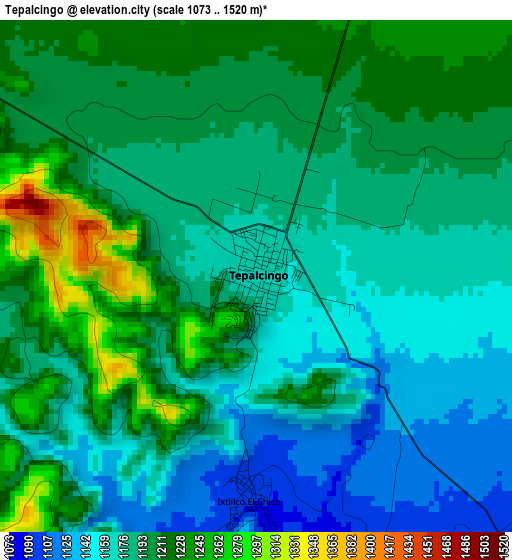
Below is the Elevation map of Tepalcingo, which displays elevation range with different colors. Scale of the first map is from 1073 to 1520 m (3520 to 4987 ft) with average elevation of 1190.8 meters (=3907 ft) [note 1]
These maps also provides idea of topography and contour of this city, they are displayed at different zoom levels. More info about maps, scale and edge coordinates you can find below images.
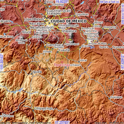
| \ | Map #1 | Map #2 | Topo.Map |
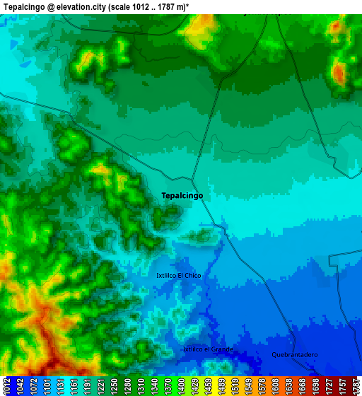
| Scale [m] | 1073..1520 m | 1012..1787 m | × |
| Scale [ft] | 3520..4987 ft | 3320..5863 ft | × |
| Average | 1190.8 m = 3907 ft | 1219.1 m = 4000 ft | × |
| Width | 9.26 km = 5.8 mi | 18.52 km = 11.5 mi | 296.4 km = 184.2 mi |
| Height | 9.26 km = 5.8 mi | 18.52 km = 11.5 mi | 296.4 km = 184.2 mi |
| ↑Max Latitude | 18.636626° | 18.678262° | 19.9225° |
| Latitude at center | 18.59498° | 18.59498° | 18.59498° |
| ↓Min Latitude | 18.553324° | 18.511657° | 17.25703° |
| ← Min Longitude | -98.889315° | -98.933261° | -100.25162° |
| Longitude center | -98.84537° | -98.84537° | -98.84537° |
| →Max Longitude | -98.801425° | -98.757479° | -97.43912° |
Nearby cities:
Cities around Tepalcingo sort by population:
• Jonacatepec elevation 1343 m
10.5 km,  24°
24°
• Telixtac 1104 m
8.2 km,  117°
117°
• Tetelilla 1184 m
7.8 km,  74°
74°
• Atotonilco 1251 m
6.2 km,  13°
13°
• Huitzililla 1218 m
12.3 km,  333°
333°
• Chalcatzingo 1372 m
12.9 km,  35°
35°
• Amacuitlapilco 1368 m
11.8 km, 17°
• Quebrantadero 1065 m
9.8 km,  143°
143°
• Huitchila 1152 m
9.7 km,  300°
300°
• Marcelino Rodríguez (San Ignacio) 1115 m
10.9 km,  99°
99°
• Tenango 1200 m
10.3 km, 72°
• Ixtlilco el Chico 1101 m
4.1 km,  182°
182°
Multilingual:
 En español:
Tepalcingo de Hidalgo elevación 1166 m.
 En France:
Tepalcingo élévation 1166 m.
 Auf Deutsch:
Tepalcingo höhe über dem Meeresspiegel ist 1166 m.

Sources and notes:
- [note 1] Map square and city borders are not equal. Map elevation data is calculated only from area inside that square.
- [src 1] Elevation data from geonames database provided with same terms of usage.
- [src 2] The elevation map of Tepalcingo is generated using elevation data from NASA's 3 arcsec (90m) resolution SRTM data.
- [src 3] Base (background) map © OpenStreetMap contributors tiles are generated by Geofabrik and OpenTopoMap.
Copyright & License:
This Tepalcingo Elevation Map is licensed under CC BY-SA. You may reuse any part from this page, if you give a proper credit by linking to this URL:
 More info on terms of use page.