Atencingo elevation
Atencingo (Puebla, Chietla), Mexico elevation is 1096 meters and Atencingo elevation in feet is 3596 ft above sea level [src 1]. Atencingo is a populated place (feature code) with elevation that is 218 meters (715 ft) smaller than average city elevation in Mexico.
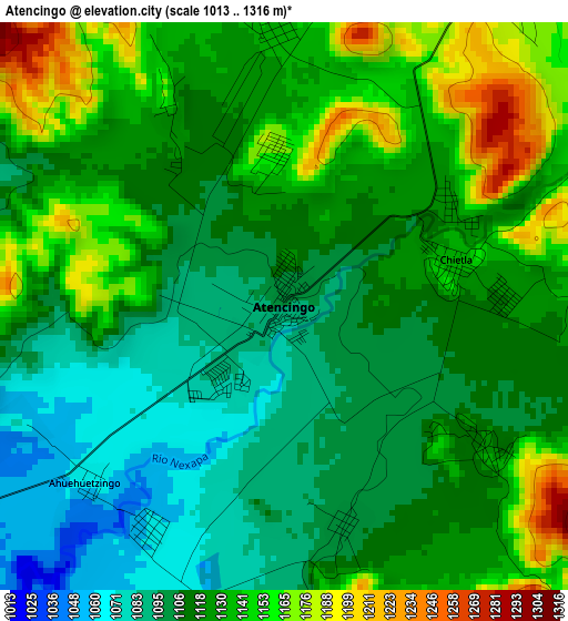
Below is the Elevation map of Atencingo, which displays elevation range with different colors. Scale of the first map is from 1013 to 1316 m (3323 to 4318 ft) with average elevation of 1122.2 meters (=3682 ft) [note 1]
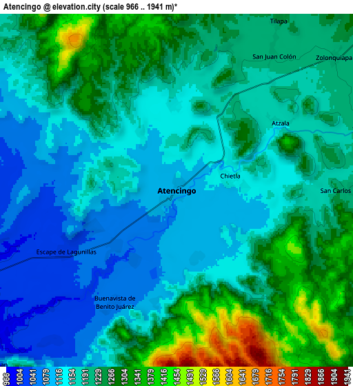
These maps also provides idea of topography and contour of this city, they are displayed at different zoom levels. More info about maps, scale and edge coordinates you can find below images.
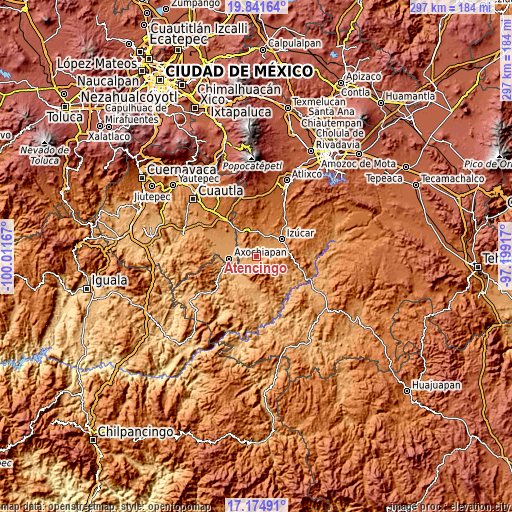
| \ | Map #1 | Map #2 | Topo.Map |
| Scale [m] | 1013..1316 m | 966..1941 m | × |
| Scale [ft] | 3323..4318 ft | 3169..6368 ft | × |
| Average | 1122.2 m = 3682 ft | 1199.5 m = 3935 ft | × |
| Width | 9.27 km = 5.8 mi | 18.53 km = 11.5 mi | 296.5 km = 184.2 mi |
| Height | 9.27 km = 5.8 mi | 18.53 km = 11.5 mi | 296.5 km = 184.2 mi |
| ↑Max Latitude | 18.555136° | 18.596792° | 19.84164° |
| Latitude at center | 18.51347° | 18.51347° | 18.51347° |
| ↓Min Latitude | 18.471794° | 18.430108° | 17.17491° |
| ← Min Longitude | -98.649365° | -98.693311° | -100.01167° |
| Longitude center | -98.60542° | -98.60542° | -98.60542° |
| →Max Longitude | -98.561475° | -98.517529° | -97.19917° |
Nearby cities:
Cities around Atencingo sort by population:
• Chietla elevation 1132 m
2.9 km,  74°
74°
• Ayutla 1208 m
11.1 km, 71°
• San Nicolás Tolentino 1211 m
11.5 km, 68°
• Tilapa 1238 m
10.9 km,  31°
31°
• Matzaco 1229 m
13.4 km, 67°
• Colucan 1258 m
13.2 km,  92°
92°
• Buenavista de Benito Juárez 1060 m
6.8 km,  209°
209°
• San Juan Colón 1203 m
8.7 km,  35°
35°
• Zolonquiapa 1205 m
10.8 km,  49°
49°
• Atzala 1161 m
6.6 km,  56°
56°
• San Carlos 1221 m
9.2 km, 89°
• San Félix Rijo 1283 m
13.2 km, 26°
Multilingual:
 En español:
Atencingo elevación 1096 m.
 En France:
Atencingo élévation 1096 m.
 Auf Deutsch:
Atencingo höhe über dem Meeresspiegel ist 1096 m.

Sources and notes:
- [note 1] Map square and city borders are not equal. Map elevation data is calculated only from area inside that square.
- [src 1] Elevation data from geonames database provided with same terms of usage.
- [src 2] The elevation map of Atencingo is generated using elevation data from NASA's 3 arcsec (90m) resolution SRTM data.
- [src 3] Base (background) map © OpenStreetMap contributors tiles are generated by Geofabrik and OpenTopoMap.
Copyright & License:
This Atencingo Elevation Map is licensed under CC BY-SA. You may reuse any part from this page, if you give a proper credit by linking to this URL:
 More info on terms of use page.