Chaucingo elevation
Chaucingo (Guerrero, Huitzuco de los Figueroa), Mexico elevation is 838 meters and Chaucingo elevation in feet is 2749 ft above sea level [src 1]. Chaucingo is a populated place (feature code) with elevation that is 476 meters (1562 ft) smaller than average city elevation in Mexico.
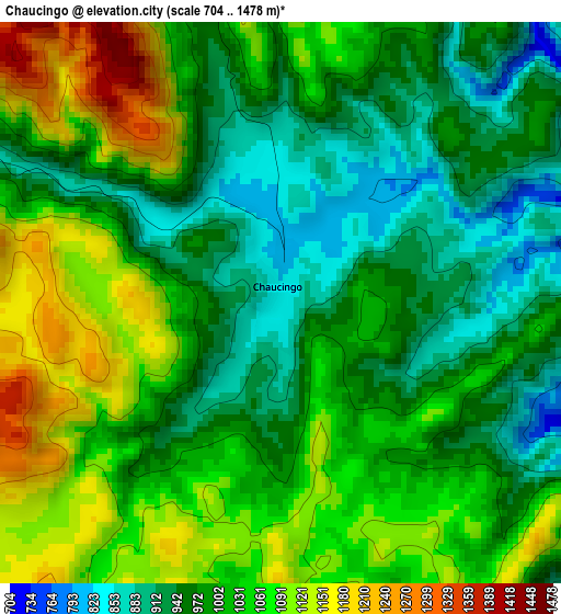
Below is the Elevation map of Chaucingo, which displays elevation range with different colors. Scale of the first map is from 704 to 1478 m (2310 to 4849 ft) with average elevation of 1012.2 meters (=3321 ft) [note 1]
These maps also provides idea of topography and contour of this city, they are displayed at different zoom levels. More info about maps, scale and edge coordinates you can find below images.
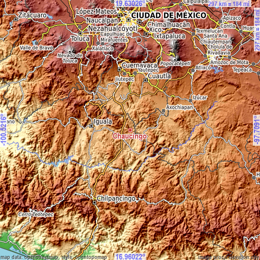
| \ | Map #1 | Topo.Map |
| Scale [m] | 704..1478 m | × |
| Scale [ft] | 2310..4849 ft | × |
| Average | 1012.2 m = 3321 ft | × |
| Width | 9.28 km = 5.8 mi | 296.9 km = 184.5 mi |
| Height | 9.28 km = 5.8 mi | 296.9 km = 184.5 mi |
| ↑Max Latitude | 18.342098° | 19.63026° |
| Latitude at center | 18.30038° | 18.30038° |
| ↓Min Latitude | 18.258652° | 16.96022° |
| ← Min Longitude | -99.159295° | -100.5216° |
| Longitude center | -99.11535° | -99.11535° |
| →Max Longitude | -99.071405° | -97.7091° |
Nearby cities:
Cities around Chaucingo sort by population:
• Ciudad de Huitzuco elevation 942 m
23.1 km,  270°
270°
• Jolalpan 883 m
28.7 km,  84°
84°
• Copalillo 886 m
30.6 km,  165°
165°
• Tilzapotla 1016 m
26.9 km,  321°
321°
• Atenango del Río 635 m
21.7 km,  177°
177°
• Pololcingo 906 m
29.3 km, 265°
• Huachinantla 867 m
15.7 km,  97°
97°
• San Miguel de las Palmas 1153 m
10.5 km,  239°
239°
• Xochitepec 1382 m
26.5 km,  107°
107°
• Valle de Vázquez 959 m
25.8 km,  10°
10°
• Paso Morelos 1108 m
13.3 km,  228°
228°
• Tequicuilco 749 m
23.5 km,  201°
201°
Multilingual:
 En español:
Chaucingo elevación 838 m.
 En France:
Chaucingo élévation 838 m.
 Auf Deutsch:
Chaucingo höhe über dem Meeresspiegel ist 838 m.

Sources and notes:
- [note 1] Map square and city borders are not equal. Map elevation data is calculated only from area inside that square.
- [src 1] Elevation data from geonames database provided with same terms of usage.
- [src 2] The elevation map of Chaucingo is generated using elevation data from NASA's 3 arcsec (90m) resolution SRTM data.
- [src 3] Base (background) map © OpenStreetMap contributors tiles are generated by Geofabrik and OpenTopoMap.
Copyright & License:
This Chaucingo Elevation Map is licensed under CC BY-SA. You may reuse any part from this page, if you give a proper credit by linking to this URL:
 More info on terms of use page.