Ciudad de Huitzuco elevation
Ciudad de Huitzuco (Guerrero, Huitzuco de los Figueroa), Mexico elevation is 942 meters and Ciudad de Huitzuco elevation in feet is 3091 ft above sea level [src 1]. Ciudad de Huitzuco is a seat of a second-order administrative division (feature code) with elevation that is 372 meters (1220 ft) smaller than average city elevation in Mexico.
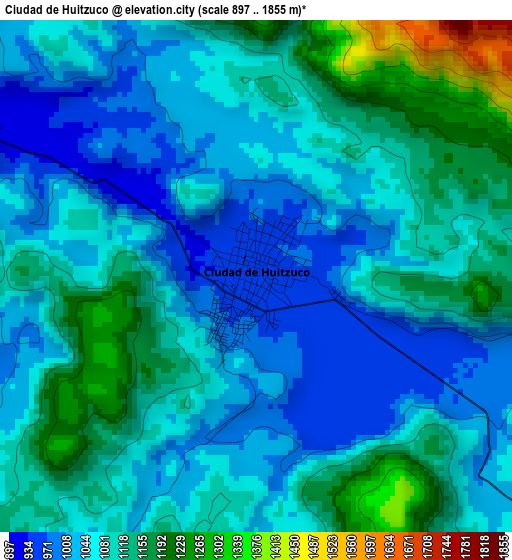
Below is the Elevation map of Ciudad de Huitzuco, which displays elevation range with different colors. Scale of the first map is from 897 to 1855 m (2943 to 6086 ft) with average elevation of 1082.9 meters (=3553 ft) [note 1]
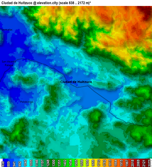
These maps also provides idea of topography and contour of this city, they are displayed at different zoom levels. More info about maps, scale and edge coordinates you can find below images.
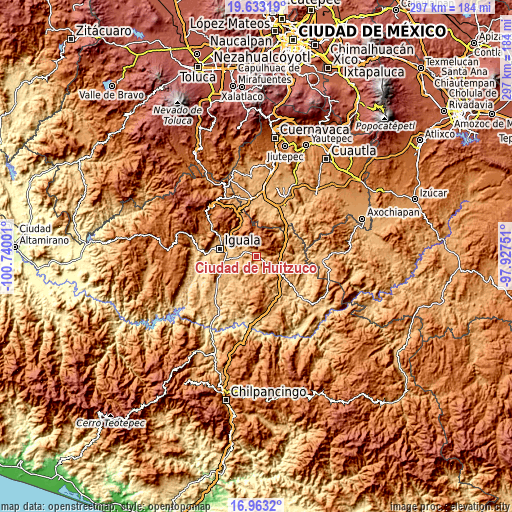
| \ | Map #1 | Map #2 | Topo.Map |
| Scale [m] | 897..1855 m | 838..2172 m | × |
| Scale [ft] | 2943..6086 ft | 2749..7126 ft | × |
| Average | 1082.9 m = 3553 ft | 1220.8 m = 4005 ft | × |
| Width | 9.28 km = 5.8 mi | 18.56 km = 11.5 mi | 296.9 km = 184.5 mi |
| Height | 9.28 km = 5.8 mi | 18.56 km = 11.5 mi | 296.9 km = 184.5 mi |
| ↑Max Latitude | 18.345057° | 18.386764° | 19.63319° |
| Latitude at center | 18.30334° | 18.30334° | 18.30334° |
| ↓Min Latitude | 18.261613° | 18.219876° | 16.9632° |
| ← Min Longitude | -99.377705° | -99.421651° | -100.74001° |
| Longitude center | -99.33376° | -99.33376° | -99.33376° |
| →Max Longitude | -99.289815° | -99.245869° | -97.92751° |
Nearby cities:
Cities around Ciudad de Huitzuco sort by population:
• Buenavista de Cuéllar elevation 1255 m
19.1 km,  335°
335°
• Tepecoacuilco de Trujano 845 m
13.9 km,  262°
262°
• Mayanalán 859 m
17.9 km,  215°
215°
• Santa Teresa 841 m
20 km,  245°
245°
• Tlaxmalac 893 m
10.6 km,  307°
307°
• Tuxpan 762 m
16.2 km,  288°
288°
• Pololcingo 906 m
6.7 km, 248°
• Zacacoyuca 907 m
21.3 km, 253°
• San Miguel de las Palmas 1153 m
15.2 km,  112°
112°
• San Vicente Palapa 856 m
8.5 km, 285°
• Paso Morelos 1108 m
16 km,  124°
124°
• Tierra Colorada 843 m
15.7 km, 256°
Multilingual:
 En español:
Ciudad de Huitzuco, Ciudad Huitzuco elevación 942 m.
 En France:
Ciudad de Huitzuco élévation 942 m.
 Auf Deutsch:
Ciudad de Huitzuco höhe über dem Meeresspiegel ist 942 m.
 На русском:
Ciudad de Huitzuco высота над уровнем моря 942 м
Sources and notes:
- [note 1] Map square and city borders are not equal. Map elevation data is calculated only from area inside that square.
- [src 1] Elevation data from geonames database provided with same terms of usage.
- [src 2] The elevation map of Ciudad de Huitzuco is generated using elevation data from NASA's 3 arcsec (90m) resolution SRTM data.
- [src 3] Base (background) map © OpenStreetMap contributors tiles are generated by Geofabrik and OpenTopoMap.
Copyright & License:
This Ciudad de Huitzuco Elevation Map is licensed under CC BY-SA. You may reuse any part from this page, if you give a proper credit by linking to this URL:
 More info on terms of use page.