Icxotitla elevation
Icxotitla (Puebla, Naupan), Mexico elevation is 1457 meters and Icxotitla elevation in feet is 4780 ft above sea level [src 1]. Icxotitla is a populated place (feature code) with elevation that is 143 meters (469 ft) bigger than average city elevation in Mexico.
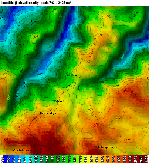
Below is the Elevation map of Icxotitla, which displays elevation range with different colors. Scale of the first map is from 703 to 2125 m (2306 to 6972 ft) with average elevation of 1421.4 meters (=4663 ft) [note 1]
These maps also provides idea of topography and contour of this city, they are displayed at different zoom levels. More info about maps, scale and edge coordinates you can find below images.
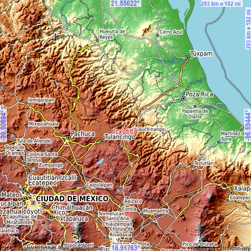
| \ | Map #1 | Topo.Map |
| Scale [m] | 703..2125 m | × |
| Scale [ft] | 2306..6972 ft | × |
| Average | 1421.4 m = 4663 ft | × |
| Width | 9.17 km = 5.7 mi | 293.4 km = 182.3 mi |
| Height | 9.17 km = 5.7 mi | 293.4 km = 182.3 mi |
| ↑Max Latitude | 20.283756° | 21.55622° |
| Latitude at center | 20.24253° | 20.24253° |
| ↓Min Latitude | 20.201293° | 18.91763° |
| ← Min Longitude | -98.144635° | -99.50694° |
| Longitude center | -98.10069° | -98.10069° |
| →Max Longitude | -98.056745° | -96.69444° |
Nearby cities:
Cities around Icxotitla sort by population:
• Huauchinango elevation 1531 m
9 km,  148°
148°
• Pahuatlán de Valle 1067 m
6.5 km,  307°
307°
• San Pablito 1183 m
9.1 km,  315°
315°
• Xolotla 1221 m
3.8 km,  296°
296°
• Atla 1128 m
4.4 km,  325°
325°
• Chimalapa 2044 m
8.7 km,  225°
225°
• Naupan 1566 m
1.5 km,  214°
214°
• Huilacapixtla 1808 m
3.9 km, 149°
• San Francisco Atotonilco 1782 m
7.5 km, 225°
• Tlaxpanaloya 1617 m
2.8 km, 227°
• Copila 1542 m
3.9 km,  28°
28°
• Chachahuantla 1744 m
5.6 km,  216°
216°
Multilingual:
 En español:
Icxotitla elevación 1457 m.
 En France:
Icxotitla élévation 1457 m.
 Auf Deutsch:
Icxotitla höhe über dem Meeresspiegel ist 1457 m.

Sources and notes:
- [note 1] Map square and city borders are not equal. Map elevation data is calculated only from area inside that square.
- [src 1] Elevation data from geonames database provided with same terms of usage.
- [src 2] The elevation map of Icxotitla is generated using elevation data from NASA's 3 arcsec (90m) resolution SRTM data.
- [src 3] Base (background) map © OpenStreetMap contributors tiles are generated by Geofabrik and OpenTopoMap.
Copyright & License:
This Icxotitla Elevation Map is licensed under CC BY-SA. You may reuse any part from this page, if you give a proper credit by linking to this URL:
 More info on terms of use page.