Copila elevation
Copila (Puebla, Naupan), Mexico elevation is 1542 meters and Copila elevation in feet is 5059 ft above sea level [src 1]. Copila is a populated place (feature code) with elevation that is 228 meters (748 ft) bigger than average city elevation in Mexico.
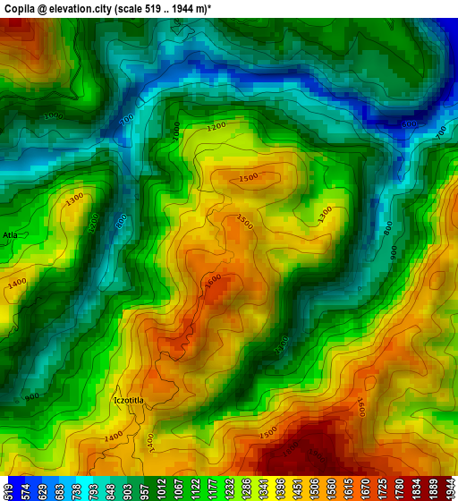
Below is the Elevation map of Copila, which displays elevation range with different colors. Scale of the first map is from 519 to 1944 m (1703 to 6378 ft) with average elevation of 1172 meters (=3845 ft) [note 1]
These maps also provides idea of topography and contour of this city, they are displayed at different zoom levels. More info about maps, scale and edge coordinates you can find below images.
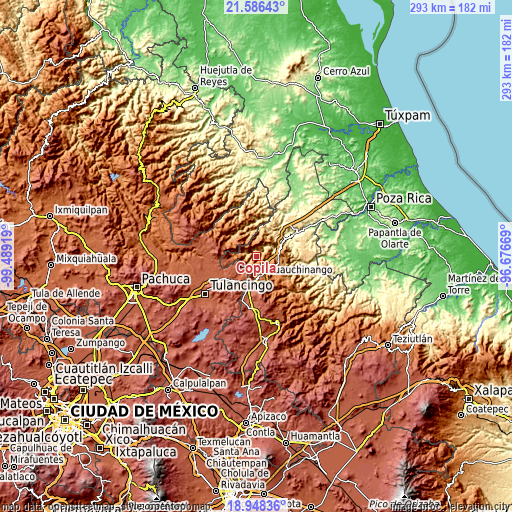
| \ | Map #1 | Topo.Map |
| Scale [m] | 519..1944 m | × |
| Scale [ft] | 1703..6378 ft | × |
| Average | 1172 m = 3845 ft | × |
| Width | 9.17 km = 5.7 mi | 293.3 km = 182.2 mi |
| Height | 9.17 km = 5.7 mi | 293.3 km = 182.2 mi |
| ↑Max Latitude | 20.314218° | 21.58643° |
| Latitude at center | 20.273° | 20.273° |
| ↓Min Latitude | 20.231772° | 18.94836° |
| ← Min Longitude | -98.126885° | -99.48919° |
| Longitude center | -98.08294° | -98.08294° |
| →Max Longitude | -98.038995° | -96.67669° |
Nearby cities:
Cities around Copila sort by population:
• Necaxa elevation 1353 m
10 km,  132°
132°
• Nuevo Necaxa 1354 m
10.6 km, 131°
• Pahuatlán de Valle 1067 m
7 km,  274°
274°
• San Pablito 1183 m
8.8 km,  290°
290°
• Xolotla 1221 m
5.5 km,  252°
252°
• Atla 1128 m
4.4 km, 273°
• Naupan 1566 m
5.4 km,  210°
210°
• Tlacuilotepec 1303 m
6.1 km,  14°
14°
• Huilacapixtla 1808 m
6.7 km,  179°
179°
• Tlaxpanaloya 1617 m
6.5 km,  216°
216°
• Icxotitla 1457 m
3.9 km, 208°
• Chachahuantla 1744 m
9.5 km, 213°
Multilingual:
 En español:
Copila elevación 1542 m.
 En France:
Copila élévation 1542 m.


Sources and notes:
- [note 1] Map square and city borders are not equal. Map elevation data is calculated only from area inside that square.
- [src 1] Elevation data from geonames database provided with same terms of usage.
- [src 2] The elevation map of Copila is generated using elevation data from NASA's 3 arcsec (90m) resolution SRTM data.
- [src 3] Base (background) map © OpenStreetMap contributors tiles are generated by Geofabrik and OpenTopoMap.
Copyright & License:
This Copila Elevation Map is licensed under CC BY-SA. You may reuse any part from this page, if you give a proper credit by linking to this URL:
 More info on terms of use page.