Pahuatlán de Valle elevation
Pahuatlán de Valle (Puebla, Pahuatlán), Mexico elevation is 1067 meters and Pahuatlán de Valle elevation in feet is 3501 ft above sea level [src 1]. Pahuatlán de Valle is a seat of a second-order administrative division (feature code) with elevation that is 247 meters (810 ft) smaller than average city elevation in Mexico.
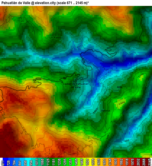
Below is the Elevation map of Pahuatlán de Valle, which displays elevation range with different colors. Scale of the first map is from 671 to 2145 m (2201 to 7037 ft) with average elevation of 1300 meters (=4265 ft) [note 1]
These maps also provides idea of topography and contour of this city, they are displayed at different zoom levels. More info about maps, scale and edge coordinates you can find below images.
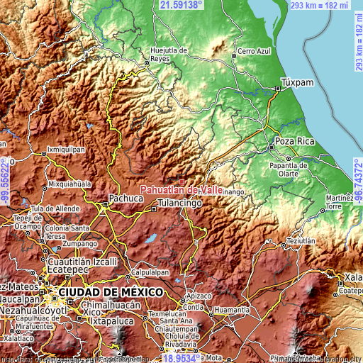
| \ | Map #1 | Topo.Map |
| Scale [m] | 671..2145 m | × |
| Scale [ft] | 2201..7037 ft | × |
| Average | 1300 m = 4265 ft | × |
| Width | 9.17 km = 5.7 mi | 293.3 km = 182.2 mi |
| Height | 9.17 km = 5.7 mi | 293.3 km = 182.2 mi |
| ↑Max Latitude | 20.319216° | 21.59138° |
| Latitude at center | 20.278° | 20.278° |
| ↓Min Latitude | 20.236773° | 18.9534° |
| ← Min Longitude | -98.193915° | -99.55622° |
| Longitude center | -98.14997° | -98.14997° |
| →Max Longitude | -98.106025° | -96.74372° |
Nearby cities:
Cities around Pahuatlán de Valle sort by population:
• San Pablito elevation 1183 m
2.8 km,  333°
333°
• Xolotla 1221 m
2.8 km,  141°
141°
• Atla 1128 m
2.7 km,  96°
96°
• Naupan 1566 m
6.7 km, 140°
• Tlaxpanaloya 1617 m
6.6 km,  151°
151°
• Copila 1542 m
7 km,  94°
94°
• Chila de Juárez 1601 m
6.2 km,  273°
273°
• Icxotitla 1457 m
6.5 km,  127°
127°
• San Nicolás 1721 m
6.3 km,  321°
321°
• Santa Mónica 1690 m
7.9 km,  295°
295°
• Chachahuantla 1744 m
8.7 km,  167°
167°
• Honey 2103 m
7.8 km,  236°
236°
Multilingual:
 En español:
Pahuatlán de Valle elevación 1067 m.
 En France:
Pahuatlán de Valle élévation 1067 m.
 Auf Deutsch:
Pahuatlán de Valle höhe über dem Meeresspiegel ist 1067 m.
 На русском:
Pahuatlán de Valle высота над уровнем моря 1067 м
Sources and notes:
- [note 1] Map square and city borders are not equal. Map elevation data is calculated only from area inside that square.
- [src 1] Elevation data from geonames database provided with same terms of usage.
- [src 2] The elevation map of Pahuatlán de Valle is generated using elevation data from NASA's 3 arcsec (90m) resolution SRTM data.
- [src 3] Base (background) map © OpenStreetMap contributors tiles are generated by Geofabrik and OpenTopoMap.
Copyright & License:
This Pahuatlán de Valle Elevation Map is licensed under CC BY-SA. You may reuse any part from this page, if you give a proper credit by linking to this URL:
 More info on terms of use page.