Honey elevation
Honey (Puebla), Mexico elevation is 2103 meters and Honey elevation in feet is 6900 ft above sea level [src 1]. Honey is a seat of a second-order administrative division (feature code) with elevation that is 789 meters (2589 ft) bigger than average city elevation in Mexico.
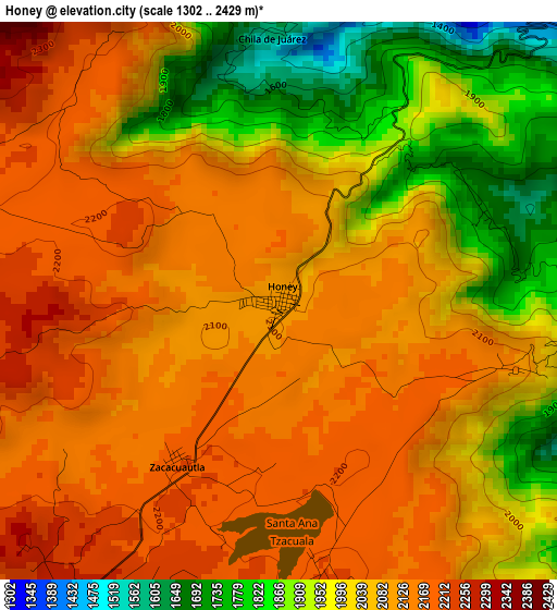
Below is the Elevation map of Honey, which displays elevation range with different colors. Scale of the first map is from 1302 to 2429 m (4272 to 7969 ft) with average elevation of 2053 meters (=6736 ft) [note 1]
These maps also provides idea of topography and contour of this city, they are displayed at different zoom levels. More info about maps, scale and edge coordinates you can find below images.
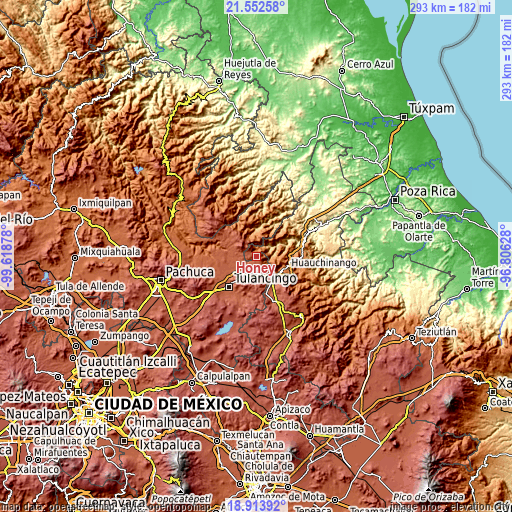
| \ | Map #1 | Topo.Map |
| Scale [m] | 1302..2429 m | × |
| Scale [ft] | 4272..7969 ft | × |
| Average | 2053 m = 6736 ft | × |
| Width | 9.17 km = 5.7 mi | 293.4 km = 182.3 mi |
| Height | 9.17 km = 5.7 mi | 293.4 km = 182.3 mi |
| ↑Max Latitude | 20.280077° | 21.55258° |
| Latitude at center | 20.23885° | 20.23885° |
| ↓Min Latitude | 20.197612° | 18.91392° |
| ← Min Longitude | -98.256475° | -99.61878° |
| Longitude center | -98.21253° | -98.21253° |
| →Max Longitude | -98.168585° | -96.80628° |
Nearby cities:
Cities around Honey sort by population:
• Santa Ana Tzacuala elevation 2214 m
4.6 km,  168°
168°
• Pahuatlán de Valle 1067 m
7.8 km,  56°
56°
• San Pablito 1183 m
8.7 km,  37°
37°
• Xolotla 1221 m
8.5 km,  75°
75°
• San Mateo 2291 m
7.2 km,  209°
209°
• Chimalapa 2044 m
7.9 km,  135°
135°
• San Francisco Atotonilco 1782 m
8 km,  127°
127°
• La Magdalena 2223 m
6.9 km,  287°
287°
• Chila de Juárez 1601 m
4.7 km,  4°
4°
• Zacacuautla 2200 m
3.2 km, 212°
• Tonalixco 2256 m
4.5 km,  259°
259°
• Santa Mónica 1690 m
7.8 km,  355°
355°
Multilingual:
 En español:
Honey elevación 2103 m.
 En France:
Honey élévation 2103 m.


Sources and notes:
- [note 1] Map square and city borders are not equal. Map elevation data is calculated only from area inside that square.
- [src 1] Elevation data from geonames database provided with same terms of usage.
- [src 2] The elevation map of Honey is generated using elevation data from NASA's 3 arcsec (90m) resolution SRTM data.
- [src 3] Base (background) map © OpenStreetMap contributors tiles are generated by Geofabrik and OpenTopoMap.
Copyright & License:
This Honey Elevation Map is licensed under CC BY-SA. You may reuse any part from this page, if you give a proper credit by linking to this URL:
 More info on terms of use page.