Nuevo Necaxa elevation
Nuevo Necaxa (Puebla, Juan Galindo), Mexico elevation is 1354 meters and Nuevo Necaxa elevation in feet is 4442 ft above sea level [src 1]. Nuevo Necaxa is a seat of a second-order administrative division (feature code) with elevation that is 40 meters (131 ft) bigger than average city elevation in Mexico.
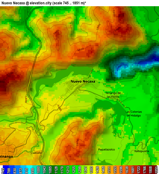
Below is the Elevation map of Nuevo Necaxa, which displays elevation range with different colors. Scale of the first map is from 745 to 1851 m (2444 to 6073 ft) with average elevation of 1380.3 meters (=4529 ft) [note 1]
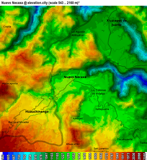
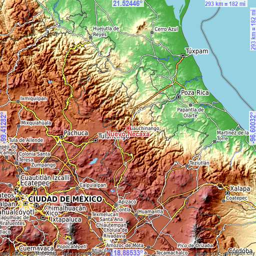
These maps also provides idea of topography and contour of this city, they are displayed at different zoom levels. More info about maps, scale and edge coordinates you can find below images.
| \ | Map #1 | Map #2 | Topo.Map |
| Scale [m] | 745..1851 m | 543..2160 m | × |
| Scale [ft] | 2444..6073 ft | 1781..7087 ft | × |
| Average | 1380.3 m = 4529 ft | 1378.3 m = 4522 ft | × |
| Width | 9.17 km = 5.7 mi | 18.34 km = 11.4 mi | 293.4 km = 182.3 mi |
| Height | 9.17 km = 5.7 mi | 18.34 km = 11.4 mi | 293.5 km = 182.4 mi |
| ↑Max Latitude | 20.251724° | 20.292947° | 21.52446° |
| Latitude at center | 20.21049° | 20.21049° | 20.21049° |
| ↓Min Latitude | 20.169245° | 20.127989° | 18.88533° |
| ← Min Longitude | -98.050515° | -98.094461° | -99.41282° |
| Longitude center | -98.00657° | -98.00657° | -98.00657° |
| →Max Longitude | -97.962625° | -97.918679° | -96.60032° |
Nearby cities:
Cities around Nuevo Necaxa sort by population:
• Huauchinango elevation 1531 m
6.5 km,  231°
231°
• Necaxa 1353 m
0.6 km,  294°
294°
• Tenango de las Flores 1305 m
2 km,  105°
105°
• Xaltepuxtla 1331 m
5.3 km,  137°
137°
• Las Colonias de Hidalgo 1284 m
3.5 km,  117°
117°
• Cuacuila 1481 m
5 km,  211°
211°
• Xaltepec 1349 m
5.1 km,  173°
173°
• Papatlazolco 1313 m
4 km,  157°
157°
• Ahuacatlán 1704 m
8.1 km,  180°
180°
• Huilacapixtla 1808 m
7.9 km,  271°
271°
• San Antonio Ocopetlatlán 1197 m
7.5 km,  57°
57°
• Tierra Negra 1206 m
6.4 km,  54°
54°
Multilingual:
 En español:
Nuevo Necaxa elevación 1354 m.
 En France:
Nuevo Necaxa élévation 1354 m.
 Auf Deutsch:
Nuevo Necaxa höhe über dem Meeresspiegel ist 1354 m.

Sources and notes:
- [note 1] Map square and city borders are not equal. Map elevation data is calculated only from area inside that square.
- [src 1] Elevation data from geonames database provided with same terms of usage.
- [src 2] The elevation map of Nuevo Necaxa is generated using elevation data from NASA's 3 arcsec (90m) resolution SRTM data.
- [src 3] Base (background) map © OpenStreetMap contributors tiles are generated by Geofabrik and OpenTopoMap.
Copyright & License:
This Nuevo Necaxa Elevation Map is licensed under CC BY-SA. You may reuse any part from this page, if you give a proper credit by linking to this URL:
 More info on terms of use page.