Huauchinango elevation
Huauchinango (Puebla), Mexico elevation is 1531 meters and Huauchinango elevation in feet is 5023 ft above sea level [src 1]. Huauchinango is a seat of a second-order administrative division (feature code) with elevation that is 217 meters (712 ft) bigger than average city elevation in Mexico.
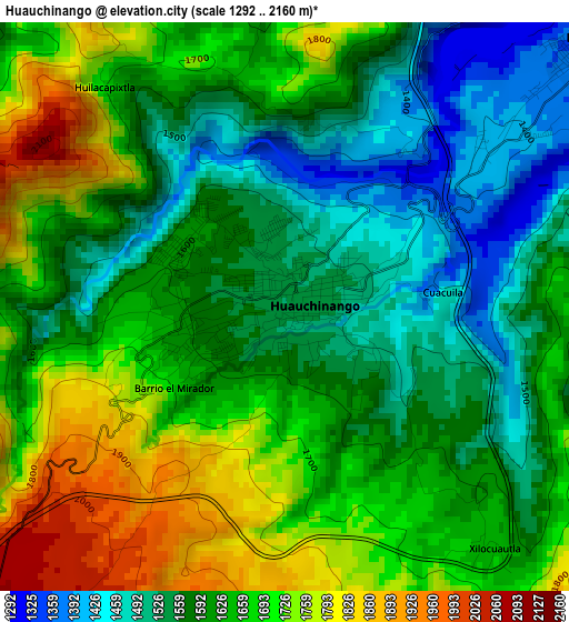
Below is the Elevation map of Huauchinango, which displays elevation range with different colors. Scale of the first map is from 1292 to 2160 m (4239 to 7087 ft) with average elevation of 1627.1 meters (=5338 ft) [note 1]
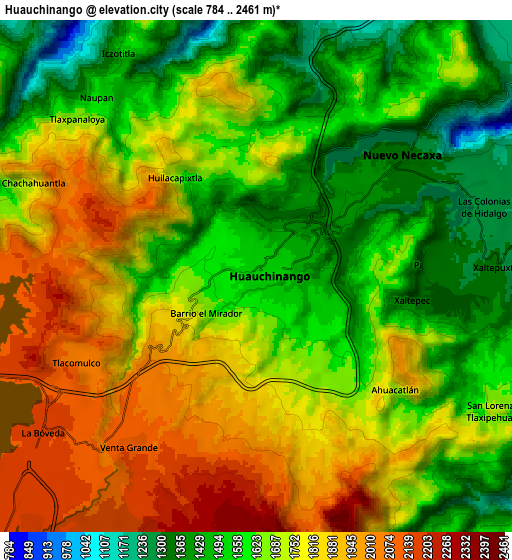
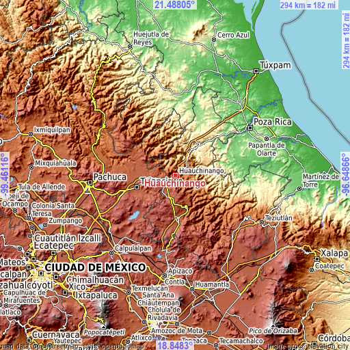
These maps also provides idea of topography and contour of this city, they are displayed at different zoom levels. More info about maps, scale and edge coordinates you can find below images.
| \ | Map #1 | Map #2 | Topo.Map |
| Scale [m] | 1292..2160 m | 784..2461 m | × |
| Scale [ft] | 4239..7087 ft | 2572..8074 ft | × |
| Average | 1627.1 m = 5338 ft | 1688.6 m = 5540 ft | × |
| Width | 9.17 km = 5.7 mi | 18.35 km = 11.4 mi | 293.5 km = 182.4 mi |
| Height | 9.17 km = 5.7 mi | 18.35 km = 11.4 mi | 293.5 km = 182.4 mi |
| ↑Max Latitude | 20.215004° | 20.256237° | 21.48805° |
| Latitude at center | 20.17376° | 20.17376° | 20.17376° |
| ↓Min Latitude | 20.132505° | 20.09124° | 18.8483° |
| ← Min Longitude | -98.098855° | -98.142801° | -99.46116° |
| Longitude center | -98.05491° | -98.05491° | -98.05491° |
| →Max Longitude | -98.010965° | -97.967019° | -96.64866° |
Nearby cities:
Cities around Huauchinango sort by population:
• Necaxa elevation 1353 m
6.2 km,  46°
46°
• Nuevo Necaxa 1354 m
6.5 km, 51°
• Tenango de las Flores 1305 m
7.8 km,  62°
62°
• Las Colonias de Hidalgo 1284 m
8.5 km,  73°
73°
• Cuacuila 1481 m
2.5 km,  94°
94°
• Xaltepec 1349 m
5.7 km,  99°
99°
• Papatlazolco 1313 m
6.6 km, 86°
• Tlacomulco 2105 m
7.2 km,  251°
251°
• Ahuacatlán 1704 m
6.4 km,  129°
129°
• Huilacapixtla 1808 m
5.1 km,  326°
326°
• Venta Grande 2128 m
7.7 km,  217°
217°
• Xilocuautla 1639 m
5 km,  139°
139°
Multilingual:
 En español:
Huauchinango elevación 1531 m.
 En France:
Huauchinango élévation 1531 m.
 Auf Deutsch:
Huauchinango höhe über dem Meeresspiegel ist 1531 m.

Sources and notes:
- [note 1] Map square and city borders are not equal. Map elevation data is calculated only from area inside that square.
- [src 1] Elevation data from geonames database provided with same terms of usage.
- [src 2] The elevation map of Huauchinango is generated using elevation data from NASA's 3 arcsec (90m) resolution SRTM data.
- [src 3] Base (background) map © OpenStreetMap contributors tiles are generated by Geofabrik and OpenTopoMap.
Copyright & License:
This Huauchinango Elevation Map is licensed under CC BY-SA. You may reuse any part from this page, if you give a proper credit by linking to this URL:
 More info on terms of use page.