Xaltepuxtla elevation
Xaltepuxtla (Puebla, Tlaola), Mexico elevation is 1331 meters and Xaltepuxtla elevation in feet is 4367 ft above sea level [src 1]. Xaltepuxtla is a populated place (feature code) with elevation that is 17 meters (56 ft) bigger than average city elevation in Mexico.
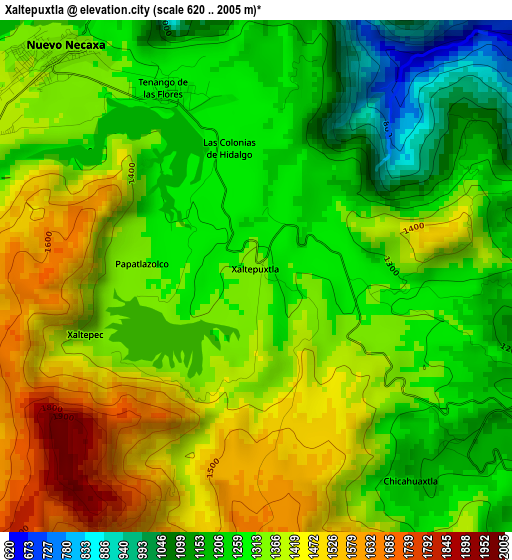
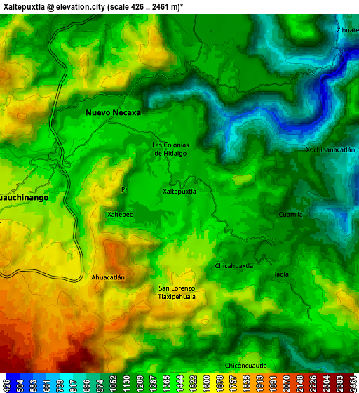
Below is the Elevation map of Xaltepuxtla, which displays elevation range with different colors. Scale of the first map is from 620 to 2005 m (2034 to 6578 ft) with average elevation of 1334.7 meters (=4379 ft) [note 1]
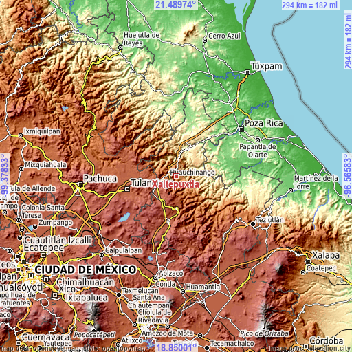
These maps also provides idea of topography and contour of this city, they are displayed at different zoom levels. More info about maps, scale and edge coordinates you can find below images.
| \ | Map #1 | Map #2 | Topo.Map |
| Scale [m] | 620..2005 m | 426..2461 m | × |
| Scale [ft] | 2034..6578 ft | 1398..8074 ft | × |
| Average | 1334.7 m = 4379 ft | 1348.2 m = 4423 ft | × |
| Width | 9.17 km = 5.7 mi | 18.35 km = 11.4 mi | 293.5 km = 182.4 mi |
| Height | 9.17 km = 5.7 mi | 18.35 km = 11.4 mi | 293.5 km = 182.4 mi |
| ↑Max Latitude | 20.216703° | 20.257936° | 21.48974° |
| Latitude at center | 20.17546° | 20.17546° | 20.17546° |
| ↓Min Latitude | 20.134206° | 20.09294° | 18.85001° |
| ← Min Longitude | -98.016025° | -98.059971° | -99.37833° |
| Longitude center | -97.97208° | -97.97208° | -97.97208° |
| →Max Longitude | -97.928135° | -97.884189° | -96.56583° |
Nearby cities:
Cities around Xaltepuxtla sort by population:
• Necaxa elevation 1353 m
5.9 km,  314°
314°
• Nuevo Necaxa 1354 m
5.3 km,  317°
317°
• Tenango de las Flores 1305 m
3.8 km,  333°
333°
• Las Colonias de Hidalgo 1284 m
2.3 km,  348°
348°
• Cuacuila 1481 m
6.2 km,  266°
266°
• Chicahuaxtla 1207 m
4.6 km,  142°
142°
• Xaltepec 1349 m
3.3 km,  249°
249°
• Papatlazolco 1313 m
2.1 km,  276°
276°
• San Lorenzo Tlaxipehuala 1721 m
5 km,  181°
181°
• Ahuacatlán 1704 m
5.6 km,  221°
221°
• Tlaola 1169 m
6.6 km,  128°
128°
• Quamila 1064 m
5.7 km,  100°
100°
Multilingual:
 En español:
Xaltepuxtla elevación 1331 m.
 En France:
Xaltepuxtla élévation 1331 m.
 Auf Deutsch:
Xaltepuxtla höhe über dem Meeresspiegel ist 1331 m.

Sources and notes:
- [note 1] Map square and city borders are not equal. Map elevation data is calculated only from area inside that square.
- [src 1] Elevation data from geonames database provided with same terms of usage.
- [src 2] The elevation map of Xaltepuxtla is generated using elevation data from NASA's 3 arcsec (90m) resolution SRTM data.
- [src 3] Base (background) map © OpenStreetMap contributors tiles are generated by Geofabrik and OpenTopoMap.
Copyright & License:
This Xaltepuxtla Elevation Map is licensed under CC BY-SA. You may reuse any part from this page, if you give a proper credit by linking to this URL:
 More info on terms of use page.