Tlaola elevation
Tlaola (Puebla), Mexico elevation is 1169 meters and Tlaola elevation in feet is 3835 ft above sea level [src 1]. Tlaola is a populated place (feature code) with elevation that is 145 meters (476 ft) smaller than average city elevation in Mexico.
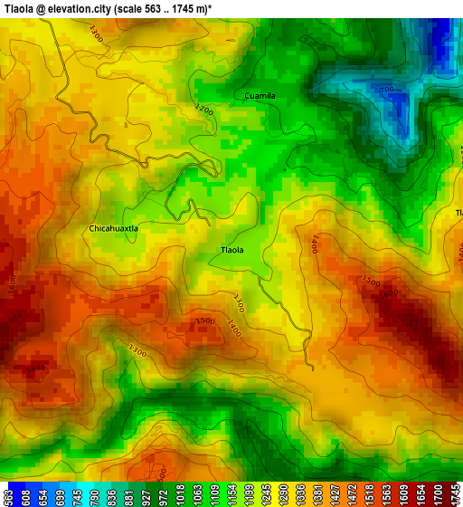
Below is the Elevation map of Tlaola, which displays elevation range with different colors. Scale of the first map is from 563 to 1745 m (1847 to 5725 ft) with average elevation of 1257.9 meters (=4127 ft) [note 1]
These maps also provides idea of topography and contour of this city, they are displayed at different zoom levels. More info about maps, scale and edge coordinates you can find below images.
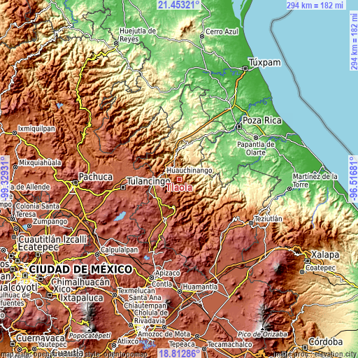
| \ | Map #1 | Topo.Map |
| Scale [m] | 563..1745 m | × |
| Scale [ft] | 1847..5725 ft | × |
| Average | 1257.9 m = 4127 ft | × |
| Width | 9.17 km = 5.7 mi | 293.6 km = 182.4 mi |
| Height | 9.18 km = 5.7 mi | 293.6 km = 182.4 mi |
| ↑Max Latitude | 20.179863° | 21.45321° |
| Latitude at center | 20.13861° | 20.13861° |
| ↓Min Latitude | 20.097346° | 18.81286° |
| ← Min Longitude | -97.967005° | -99.32931° |
| Longitude center | -97.92306° | -97.92306° |
| →Max Longitude | -97.879115° | -96.51681° |
Nearby cities:
Cities around Tlaola sort by population:
• Xaltepuxtla elevation 1331 m
6.6 km,  308°
308°
• Chiconcuautla 1507 m
5.1 km,  198°
198°
• Las Colonias de Hidalgo 1284 m
8.5 km,  318°
318°
• Chicahuaxtla 1207 m
2.4 km,  280°
280°
• Xaltepec 1349 m
8.7 km,  289°
289°
• Xochinanacatlán 963 m
6.8 km,  22°
22°
• Papatlazolco 1313 m
8.4 km,  301°
301°
• San Lorenzo Tlaxipehuala 1721 m
5.4 km,  260°
260°
• Tlaltepango 1318 m
4.8 km,  81°
81°
• Toxtla 1393 m
8.4 km, 197°
• Quamila 1064 m
3.1 km,  8°
8°
• San Cristóbal Xochimilpa 1084 m
8.2 km,  168°
168°
Multilingual:
 En español:
Tlaola elevación 1169 m.
 En France:
Tlaola élévation 1169 m.


Sources and notes:
- [note 1] Map square and city borders are not equal. Map elevation data is calculated only from area inside that square.
- [src 1] Elevation data from geonames database provided with same terms of usage.
- [src 2] The elevation map of Tlaola is generated using elevation data from NASA's 3 arcsec (90m) resolution SRTM data.
- [src 3] Base (background) map © OpenStreetMap contributors tiles are generated by Geofabrik and OpenTopoMap.
Copyright & License:
This Tlaola Elevation Map is licensed under CC BY-SA. You may reuse any part from this page, if you give a proper credit by linking to this URL:
 More info on terms of use page.