Vicente Guerrero elevation
Vicente Guerrero (Chiapas, Ocozocoautla de Espinosa), Mexico elevation is 876 meters and Vicente Guerrero elevation in feet is 2874 ft above sea level [src 1]. Vicente Guerrero is a populated place (feature code) with elevation that is 438 meters (1437 ft) smaller than average city elevation in Mexico.
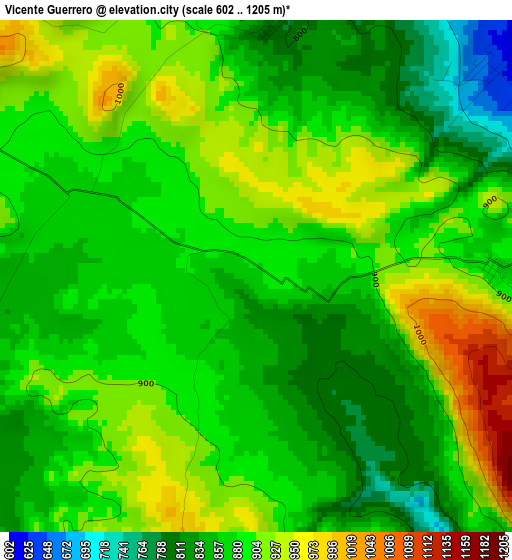
Below is the Elevation map of Vicente Guerrero, which displays elevation range with different colors. Scale of the first map is from 602 to 1205 m (1975 to 3953 ft) with average elevation of 881.8 meters (=2893 ft) [note 1]
These maps also provides idea of topography and contour of this city, they are displayed at different zoom levels. More info about maps, scale and edge coordinates you can find below images.
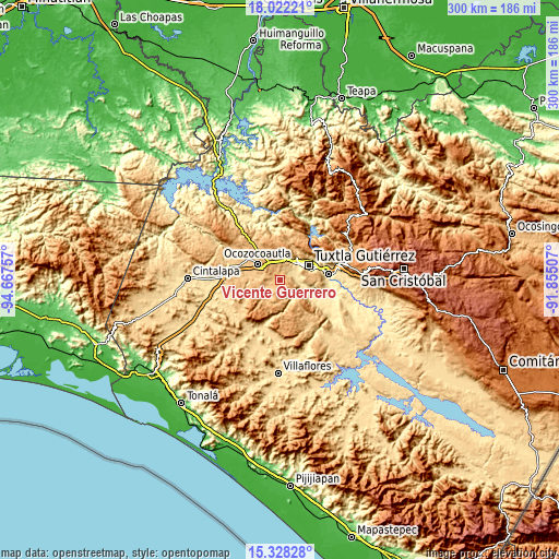
| \ | Map #1 | Topo.Map |
| Scale [m] | 602..1205 m | × |
| Scale [ft] | 1975..3953 ft | × |
| Average | 881.8 m = 2893 ft | × |
| Width | 9.36 km = 5.8 mi | 299.5 km = 186.1 mi |
| Height | 9.36 km = 5.8 mi | 299.6 km = 186.2 mi |
| ↑Max Latitude | 16.722082° | 18.02221° |
| Latitude at center | 16.67999° | 16.67999° |
| ↓Min Latitude | 16.637889° | 15.32828° |
| ← Min Longitude | -93.305265° | -94.66757° |
| Longitude center | -93.26132° | -93.26132° |
| →Max Longitude | -93.217375° | -91.85507° |
Nearby cities:
Cities around Vicente Guerrero sort by population:
• Tuxtla elevation 526 m
18.1 km,  60°
60°
• Ocozocoautla de Espinosa 828 m
15.2 km,  307°
307°
• Berriozábal 904 m
13.2 km,  355°
355°
• Suchiapa 464 m
18.1 km,  109°
109°
• Copoya 852 m
15.4 km,  76°
76°
• El Jobo 881 m
16.8 km, 80°
• Pacú 463 m
14.4 km, 109°
• Guadalupe Victoria 799 m
9.8 km,  232°
232°
• Ignacio Zaragoza (El Morro) 845 m
13.1 km, 226°
• Viva Cárdenas 843 m
18.8 km,  22°
22°
• La Independencia (Las Pilas) 855 m
1.3 km,  102°
102°
• Hermenegildo Galeana 888 m
15.5 km,  222°
222°
Multilingual:
 En español:
Vicente Guerrero elevación 876 m.
 En France:
Vicente Guerrero élévation 876 m.
 Auf Deutsch:
Vicente Guerrero höhe über dem Meeresspiegel ist 876 m.

Sources and notes:
- [note 1] Map square and city borders are not equal. Map elevation data is calculated only from area inside that square.
- [src 1] Elevation data from geonames database provided with same terms of usage.
- [src 2] The elevation map of Vicente Guerrero is generated using elevation data from NASA's 3 arcsec (90m) resolution SRTM data.
- [src 3] Base (background) map © OpenStreetMap contributors tiles are generated by Geofabrik and OpenTopoMap.
Copyright & License:
This Vicente Guerrero Elevation Map is licensed under CC BY-SA. You may reuse any part from this page, if you give a proper credit by linking to this URL:
 More info on terms of use page.