Pacú elevation
Pacú (Chiapas, Suchiapa), Mexico elevation is 463 meters and Pacú elevation in feet is 1519 ft above sea level [src 1]. Pacú is a populated place (feature code) with elevation that is 851 meters (2792 ft) smaller than average city elevation in Mexico.
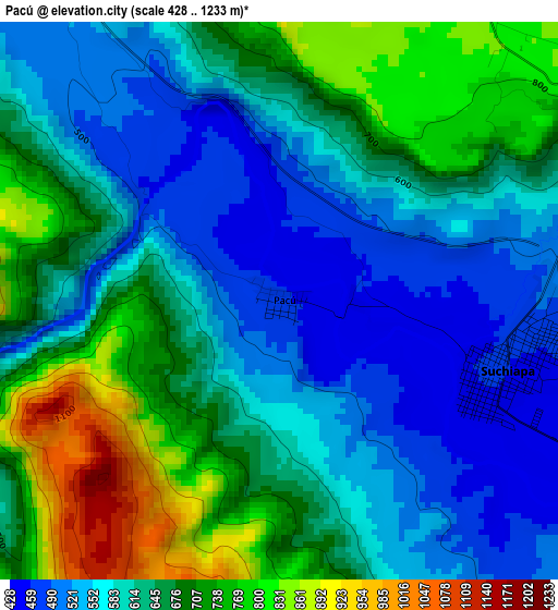
Below is the Elevation map of Pacú, which displays elevation range with different colors. Scale of the first map is from 428 to 1233 m (1404 to 4045 ft) with average elevation of 630.6 meters (=2069 ft) [note 1]
These maps also provides idea of topography and contour of this city, they are displayed at different zoom levels. More info about maps, scale and edge coordinates you can find below images.
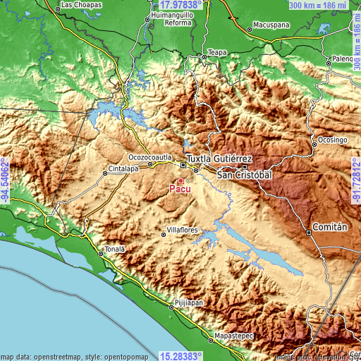
| \ | Map #1 | Topo.Map |
| Scale [m] | 428..1233 m | × |
| Scale [ft] | 1404..4045 ft | × |
| Average | 630.6 m = 2069 ft | × |
| Width | 9.36 km = 5.8 mi | 299.6 km = 186.2 mi |
| Height | 9.36 km = 5.8 mi | 299.6 km = 186.2 mi |
| ↑Max Latitude | 16.677941° | 17.97838° |
| Latitude at center | 16.63584° | 16.63584° |
| ↓Min Latitude | 16.593729° | 15.28383° |
| ← Min Longitude | -93.178315° | -94.54062° |
| Longitude center | -93.13437° | -93.13437° |
| →Max Longitude | -93.090425° | -91.72812° |
Nearby cities:
Cities around Pacú sort by population:
• Tuxtla elevation 526 m
14 km,  9°
9°
• Chiapa de Corzo 429 m
15.3 km,  58°
58°
• Suchiapa 464 m
3.8 km,  107°
107°
• Copoya 852 m
8.6 km, 9°
• El Jobo 881 m
8.1 km,  22°
22°
• Jardínes del Grijalva 414 m
14.8 km,  45°
45°
• Vicente Guerrero 876 m
14.4 km,  289°
289°
• Salvador Urbina 408 m
14.1 km,  90°
90°
• Las Flechas 401 m
13.6 km, 58°
• Galecio Narcia 448 m
13.2 km, 113°
• La Independencia (Las Pilas) 855 m
13.1 km, 290°
• América Libre 423 m
15.4 km,  98°
98°
Multilingual:
 En español:
Pacú elevación 463 m.
 En France:
Pacú élévation 463 m.


Sources and notes:
- [note 1] Map square and city borders are not equal. Map elevation data is calculated only from area inside that square.
- [src 1] Elevation data from geonames database provided with same terms of usage.
- [src 2] The elevation map of Pacú is generated using elevation data from NASA's 3 arcsec (90m) resolution SRTM data.
- [src 3] Base (background) map © OpenStreetMap contributors tiles are generated by Geofabrik and OpenTopoMap.
Copyright & License:
This Pacú Elevation Map is licensed under CC BY-SA. You may reuse any part from this page, if you give a proper credit by linking to this URL:
 More info on terms of use page.