Las Flechas elevation
Las Flechas (Chiapas, Chiapa de Corzo), Mexico elevation is 401 meters and Las Flechas elevation in feet is 1316 ft above sea level [src 1]. Las Flechas is a populated place (feature code) with elevation that is 913 meters (2995 ft) smaller than average city elevation in Mexico.
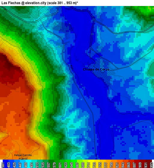
Below is the Elevation map of Las Flechas, which displays elevation range with different colors. Scale of the first map is from 381 to 953 m (1250 to 3127 ft) with average elevation of 531.9 meters (=1745 ft) [note 1]
These maps also provides idea of topography and contour of this city, they are displayed at different zoom levels. More info about maps, scale and edge coordinates you can find below images.
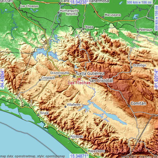
| \ | Map #1 | Topo.Map |
| Scale [m] | 381..953 m | × |
| Scale [ft] | 1250..3127 ft | × |
| Average | 531.9 m = 1745 ft | × |
| Width | 9.36 km = 5.8 mi | 299.5 km = 186.1 mi |
| Height | 9.36 km = 5.8 mi | 299.5 km = 186.1 mi |
| ↑Max Latitude | 16.742367° | 18.04235° |
| Latitude at center | 16.70028° | 16.70028° |
| ↓Min Latitude | 16.658184° | 15.34871° |
| ← Min Longitude | -93.070335° | -94.43264° |
| Longitude center | -93.02639° | -93.02639° |
| →Max Longitude | -92.982445° | -91.62014° |
Nearby cities:
Cities around Las Flechas sort by population:
• Tuxtla elevation 526 m
11.4 km,  305°
305°
• Chiapa de Corzo 429 m
1.8 km,  61°
61°
• Suchiapa 464 m
11.5 km,  223°
223°
• Copoya 852 m
10.1 km,  277°
277°
• El Jobo 881 m
8.5 km,  272°
272°
• Jardínes del Grijalva 414 m
3.3 km,  344°
344°
• Salvador Urbina 408 m
7.7 km,  160°
160°
• Galecio Narcia 448 m
12.5 km,  177°
177°
• Juan del Grijalva 509 m
6.1 km, 59°
• Aztlán 1143 m
13.4 km, 55°
• América Libre 423 m
10.2 km, 158°
• Nuevo Carmen Tonapac 550 m
7.6 km,  93°
93°
Multilingual:
 En español:
Las Flechas elevación 401 m.
 En France:
Las Flechas élévation 401 m.
 Auf Deutsch:
Las Flechas höhe über dem Meeresspiegel ist 401 m.

Sources and notes:
- [note 1] Map square and city borders are not equal. Map elevation data is calculated only from area inside that square.
- [src 1] Elevation data from geonames database provided with same terms of usage.
- [src 2] The elevation map of Las Flechas is generated using elevation data from NASA's 3 arcsec (90m) resolution SRTM data.
- [src 3] Base (background) map © OpenStreetMap contributors tiles are generated by Geofabrik and OpenTopoMap.
Copyright & License:
This Las Flechas Elevation Map is licensed under CC BY-SA. You may reuse any part from this page, if you give a proper credit by linking to this URL:
 More info on terms of use page.