Berriozábal elevation
Berriozábal (Chiapas), Mexico elevation is 904 meters and Berriozábal elevation in feet is 2966 ft above sea level [src 1]. Berriozábal is a seat of a second-order administrative division (feature code) with elevation that is 410 meters (1345 ft) smaller than average city elevation in Mexico.
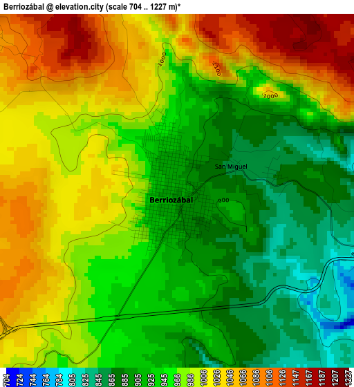
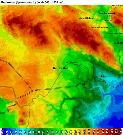
Below is the Elevation map of Berriozábal, which displays elevation range with different colors. Scale of the first map is from 704 to 1227 m (2310 to 4026 ft) with average elevation of 967.5 meters (=3174 ft) [note 1]
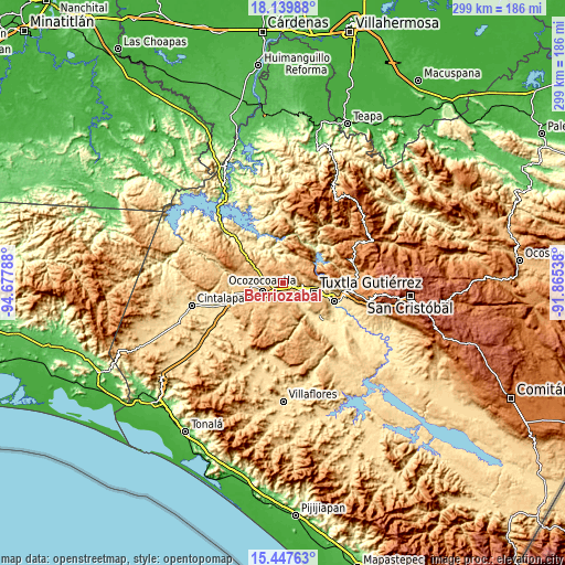
These maps also provides idea of topography and contour of this city, they are displayed at different zoom levels. More info about maps, scale and edge coordinates you can find below images.
| \ | Map #1 | Map #2 | Topo.Map |
| Scale [m] | 704..1227 m | 549..1255 m | × |
| Scale [ft] | 2310..4026 ft | 1801..4117 ft | × |
| Average | 967.5 m = 3174 ft | 949 m = 3114 ft | × |
| Width | 9.36 km = 5.8 mi | 18.71 km = 11.6 mi | 299.4 km = 186 mi |
| Height | 9.36 km = 5.8 mi | 18.71 km = 11.6 mi | 299.4 km = 186 mi |
| ↑Max Latitude | 16.840595° | 16.882651° | 18.13988° |
| Latitude at center | 16.79853° | 16.79853° | 16.79853° |
| ↓Min Latitude | 16.756455° | 16.714371° | 15.44763° |
| ← Min Longitude | -93.315575° | -93.359521° | -94.67788° |
| Longitude center | -93.27163° | -93.27163° | -93.27163° |
| →Max Longitude | -93.227685° | -93.183739° | -91.86538° |
Nearby cities:
Cities around Berriozábal sort by population:
• Tuxtla elevation 526 m
17.4 km,  104°
104°
• Ocozocoautla de Espinosa 828 m
11.7 km,  249°
249°
• San Fernando 880 m
10.6 km,  40°
40°
• El Progreso 921 m
10.2 km,  31°
31°
• El Copalar 871 m
10.7 km, 35°
• Vicente Guerrero 876 m
13.2 km,  175°
175°
• Francisco I. Madero 868 m
10.2 km, 34°
• Benito Juárez 969 m
12.9 km, 42°
• Viva Cárdenas 843 m
9.3 km,  63°
63°
• Las Maravillas 287 m
18.6 km,  343°
343°
• La Independencia (Las Pilas) 855 m
13.7 km,  170°
170°
• Álvaro Obregón 867 m
9.8 km, 59°
Multilingual:
 En español:
Berriozábal elevación 904 m.
 En France:
Berriozábal élévation 904 m.
 Auf Deutsch:
Berriozábal höhe über dem Meeresspiegel ist 904 m.

Sources and notes:
- [note 1] Map square and city borders are not equal. Map elevation data is calculated only from area inside that square.
- [src 1] Elevation data from geonames database provided with same terms of usage.
- [src 2] The elevation map of Berriozábal is generated using elevation data from NASA's 3 arcsec (90m) resolution SRTM data.
- [src 3] Base (background) map © OpenStreetMap contributors tiles are generated by Geofabrik and OpenTopoMap.
Copyright & License:
This Berriozábal Elevation Map is licensed under CC BY-SA. You may reuse any part from this page, if you give a proper credit by linking to this URL:
 More info on terms of use page.