Hermenegildo Galeana elevation
Hermenegildo Galeana (Chiapas, Ocozocoautla de Espinosa), Mexico elevation is 888 meters and Hermenegildo Galeana elevation in feet is 2913 ft above sea level [src 1]. Hermenegildo Galeana is a populated place (feature code) with elevation that is 426 meters (1398 ft) smaller than average city elevation in Mexico.
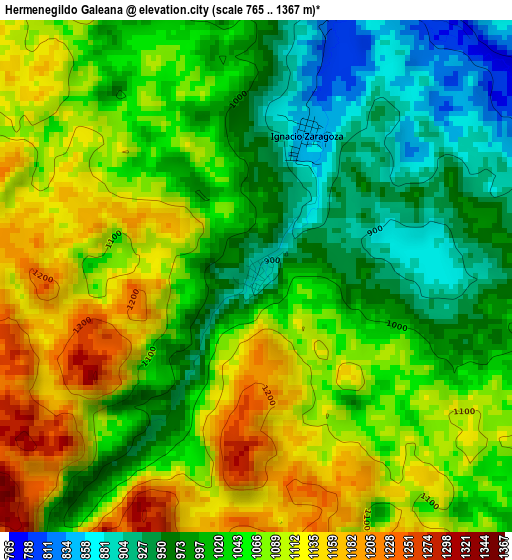
Below is the Elevation map of Hermenegildo Galeana, which displays elevation range with different colors. Scale of the first map is from 765 to 1367 m (2510 to 4485 ft) with average elevation of 1043.6 meters (=3424 ft) [note 1]
These maps also provides idea of topography and contour of this city, they are displayed at different zoom levels. More info about maps, scale and edge coordinates you can find below images.
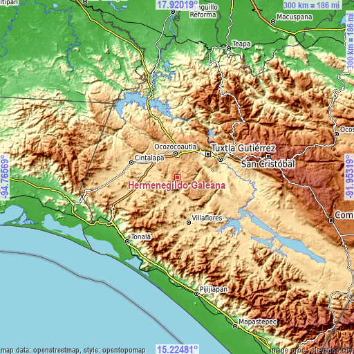
| \ | Map #1 | Topo.Map |
| Scale [m] | 765..1367 m | × |
| Scale [ft] | 2510..4485 ft | × |
| Average | 1043.6 m = 3424 ft | × |
| Width | 9.37 km = 5.8 mi | 299.7 km = 186.2 mi |
| Height | 9.37 km = 5.8 mi | 299.7 km = 186.2 mi |
| ↑Max Latitude | 16.619334° | 17.92019° |
| Latitude at center | 16.57722° | 16.57722° |
| ↓Min Latitude | 16.535097° | 15.22481° |
| ← Min Longitude | -93.403385° | -94.76569° |
| Longitude center | -93.35944° | -93.35944° |
| →Max Longitude | -93.315495° | -91.95319° |
Nearby cities:
Cities around Hermenegildo Galeana sort by population:
• Ocozocoautla de Espinosa elevation 828 m
20.6 km,  355°
355°
• Jesús María Garza 630 m
21.3 km,  160°
160°
• Cristóbal Obregón 662 m
19.2 km,  212°
212°
• Benito Juárez 615 m
17.1 km,  166°
166°
• Nuevo México 686 m
14.6 km, 214°
• Vicente Guerrero 876 m
15.5 km,  42°
42°
• Guadalupe Victoria 799 m
6.1 km,  25°
25°
• Roblada Grande 1148 m
20.1 km,  119°
119°
• Ignacio Zaragoza (El Morro) 845 m
2.6 km,  20°
20°
• Quintana Roo 553 m
21.8 km,  278°
278°
• La Independencia (Las Pilas) 855 m
16.2 km,  46°
46°
• Alfonso Moguel 903 m
18.6 km,  302°
302°
Multilingual:
 En español:
Hermenegildo Galeana elevación 888 m.
 En France:
Hermenegildo Galeana élévation 888 m.
 Auf Deutsch:
Hermenegildo Galeana höhe über dem Meeresspiegel ist 888 m.
 На русском:
Hermenegildo Galeana высота над уровнем моря 888 м
Sources and notes:
- [note 1] Map square and city borders are not equal. Map elevation data is calculated only from area inside that square.
- [src 1] Elevation data from geonames database provided with same terms of usage.
- [src 2] The elevation map of Hermenegildo Galeana is generated using elevation data from NASA's 3 arcsec (90m) resolution SRTM data.
- [src 3] Base (background) map © OpenStreetMap contributors tiles are generated by Geofabrik and OpenTopoMap.
Copyright & License:
This Hermenegildo Galeana Elevation Map is licensed under CC BY-SA. You may reuse any part from this page, if you give a proper credit by linking to this URL:
 More info on terms of use page.