Roblada Grande elevation
Roblada Grande (Chiapas, Villaflores), Mexico elevation is 1148 meters and Roblada Grande elevation in feet is 3766 ft above sea level [src 1]. Roblada Grande is a populated place (feature code) with elevation that is 166 meters (545 ft) smaller than average city elevation in Mexico.
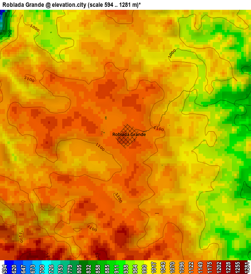
Below is the Elevation map of Roblada Grande, which displays elevation range with different colors. Scale of the first map is from 594 to 1281 m (1949 to 4203 ft) with average elevation of 1059.9 meters (=3477 ft) [note 1]
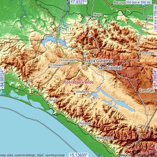
These maps also provides idea of topography and contour of this city, they are displayed at different zoom levels. More info about maps, scale and edge coordinates you can find below images.
| \ | Map #1 | Topo.Map |
| Scale [m] | 594..1281 m | × |
| Scale [ft] | 1949..4203 ft | × |
| Average | 1059.9 m = 3477 ft | × |
| Width | 9.37 km = 5.8 mi | 299.8 km = 186.3 mi |
| Height | 9.37 km = 5.8 mi | 299.9 km = 186.3 mi |
| ↑Max Latitude | 16.531223° | 17.8327° |
| Latitude at center | 16.48909° | 16.48909° |
| ↓Min Latitude | 16.446947° | 15.13609° |
| ← Min Longitude | -93.238935° | -94.60124° |
| Longitude center | -93.19499° | -93.19499° |
| →Max Longitude | -93.151045° | -91.78874° |
Nearby cities:
Cities around Roblada Grande sort by population:
• Suchiapa elevation 464 m
18.2 km,  33°
33°
• Jesús María Garza 630 m
14.7 km,  225°
225°
• Benito Juárez 615 m
15.2 km,  243°
243°
• Cuauhtémoc 564 m
19.5 km,  184°
184°
• Villa Hidalgo 537 m
21 km,  168°
168°
• Pacú 463 m
17.5 km,  21°
21°
• Guadalupe Victoria 799 m
21.4 km,  315°
315°
• Ignacio Zaragoza (El Morro) 845 m
20.7 km,  306°
306°
• Dieciséis de Septiembre 530 m
21.4 km, 174°
• Hermenegildo Galeana 888 m
20.1 km,  299°
299°
• Ignacio Zaragoza 535 m
14.5 km,  153°
153°
• Calzada Larga 709 m
20 km,  219°
219°
Multilingual:
 En español:
Roblada Grande elevación 1148 m.
 En France:
Roblada Grande élévation 1148 m.
 Auf Deutsch:
Roblada Grande höhe über dem Meeresspiegel ist 1148 m.

Sources and notes:
- [note 1] Map square and city borders are not equal. Map elevation data is calculated only from area inside that square.
- [src 1] Elevation data from geonames database provided with same terms of usage.
- [src 2] The elevation map of Roblada Grande is generated using elevation data from NASA's 3 arcsec (90m) resolution SRTM data.
- [src 3] Base (background) map © OpenStreetMap contributors tiles are generated by Geofabrik and OpenTopoMap.
Copyright & License:
This Roblada Grande Elevation Map is licensed under CC BY-SA. You may reuse any part from this page, if you give a proper credit by linking to this URL:
 More info on terms of use page.