Los Pilares elevation
Los Pilares (Tlaxcala, Huamantla), Mexico elevation is 2691 meters and Los Pilares elevation in feet is 8829 ft above sea level [src 1]. Los Pilares is a populated place (feature code) with elevation that is 1377 meters (4518 ft) bigger than average city elevation in Mexico.
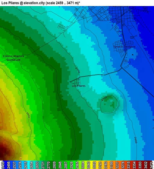
Below is the Elevation map of Los Pilares, which displays elevation range with different colors. Scale of the first map is from 2459 to 3471 m (8068 to 11388 ft) with average elevation of 2729.9 meters (=8956 ft) [note 1]
These maps also provides idea of topography and contour of this city, they are displayed at different zoom levels. More info about maps, scale and edge coordinates you can find below images.
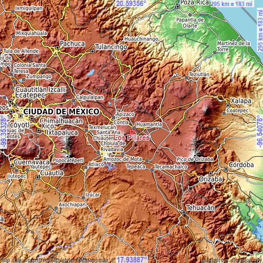
| \ | Map #1 | Topo.Map |
| Scale [m] | 2459..3471 m | × |
| Scale [ft] | 8068..11388 ft | × |
| Average | 2729.9 m = 8956 ft | × |
| Width | 9.22 km = 5.7 mi | 295.2 km = 183.4 mi |
| Height | 9.22 km = 5.7 mi | 295.2 km = 183.4 mi |
| ↑Max Latitude | 19.313068° | 20.59356° |
| Latitude at center | 19.27159° | 19.27159° |
| ↓Min Latitude | 19.230102° | 17.93887° |
| ← Min Longitude | -97.990975° | -99.35328° |
| Longitude center | -97.94703° | -97.94703° |
| →Max Longitude | -97.903085° | -96.54078° |
Nearby cities:
Cities around Los Pilares sort by population:
• Huamantla elevation 2519 m
5.3 km,  25°
25°
• Ignacio Zaragoza 2531 m
3.6 km,  49°
49°
• Ixtenco 2507 m
6 km,  111°
111°
• Zitlaltépec 2564 m
8.6 km,  150°
150°
• San José Teacalco 2609 m
14.2 km,  299°
299°
• El Rincón Citlaltépetl 2600 m
14 km,  156°
156°
• Benito Juárez 2447 m
12.1 km,  19°
19°
• Máximo Serdán 2402 m
12.5 km,  94°
94°
• El Carmen Xalpatlahuaya 2501 m
13.9 km,  344°
344°
• Lázaro Cárdenas 2525 m
10.6 km, 336°
• José María Morelos 2652 m
6 km,  327°
327°
• Colonia Cuauhtémoc 2560 m
7 km, 344°
Multilingual:
 En español:
Los Pilares elevación 2691 m.
 En France:
Los Pilares élévation 2691 m.
 Auf Deutsch:
Los Pilares höhe über dem Meeresspiegel ist 2691 m.

Sources and notes:
- [note 1] Map square and city borders are not equal. Map elevation data is calculated only from area inside that square.
- [src 1] Elevation data from geonames database provided with same terms of usage.
- [src 2] The elevation map of Los Pilares is generated using elevation data from NASA's 3 arcsec (90m) resolution SRTM data.
- [src 3] Base (background) map © OpenStreetMap contributors tiles are generated by Geofabrik and OpenTopoMap.
Copyright & License:
This Los Pilares Elevation Map is licensed under CC BY-SA. You may reuse any part from this page, if you give a proper credit by linking to this URL:
 More info on terms of use page.