El Rincón Citlaltépetl elevation
El Rincón Citlaltépetl (Puebla, Nopalucan), Mexico elevation is 2600 meters and El Rincón Citlaltépetl elevation in feet is 8530 ft above sea level [src 1]. El Rincón Citlaltépetl is a populated place (feature code) with elevation that is 1286 meters (4219 ft) bigger than average city elevation in Mexico.
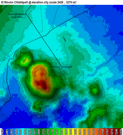
Below is the Elevation map of El Rincón Citlaltépetl, which displays elevation range with different colors. Scale of the first map is from 2428 to 3279 m (7966 to 10758 ft) with average elevation of 2593.3 meters (=8508 ft) [note 1]
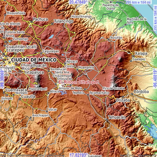
These maps also provides idea of topography and contour of this city, they are displayed at different zoom levels. More info about maps, scale and edge coordinates you can find below images.
| \ | Map #1 | Map #2 | Topo.Map |
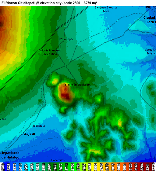
| Scale [m] | 2428..3279 m | 2300..3279 m | × |
| Scale [ft] | 7966..10758 ft | 7546..10758 ft | × |
| Average | 2593.3 m = 8508 ft | 2565.6 m = 8417 ft | × |
| Width | 9.23 km = 5.7 mi | 18.46 km = 11.5 mi | 295.4 km = 183.6 mi |
| Height | 9.23 km = 5.7 mi | 18.46 km = 11.5 mi | 295.4 km = 183.6 mi |
| ↑Max Latitude | 19.197067° | 19.238563° | 20.47849° |
| Latitude at center | 19.15556° | 19.15556° | 19.15556° |
| ↓Min Latitude | 19.114043° | 19.072515° | 17.82193° |
| ← Min Longitude | -97.938385° | -97.982331° | -99.30069° |
| Longitude center | -97.89444° | -97.89444° | -97.89444° |
| →Max Longitude | -97.850495° | -97.806549° | -96.48819° |
Nearby cities:
Cities around El Rincón Citlaltépetl sort by population:
• Acajete elevation 2468 m
7.8 km,  231°
231°
• Tepatlaxco de Hidalgo 2351 m
11.8 km,  224°
224°
• San Juan Tepulco 2581 m
10.8 km,  246°
246°
• Santa María Ixtiyucán 2429 m
9.4 km,  68°
68°
• Nopalucán 2460 m
10.3 km,  47°
47°
• Ixtenco 2507 m
10.7 km,  0°
0°
• Zitlaltépec 2564 m
5.5 km,  345°
345°
• Tlacamilco 2358 m
9.2 km,  194°
194°
• Apango de Zaragoza 2353 m
10.8 km,  206°
206°
• San Antonio Tlacamilco 2344 m
11 km,  200°
200°
• San Pedro la Joya 2365 m
11.7 km,  149°
149°
• Juan de la Granja 2409 m
11.6 km, 50°
Multilingual:
 En español:
El Rincón Citlaltépetl elevación 2600 m.
 En France:
El Rincón Citlaltépetl élévation 2600 m.
 Auf Deutsch:
El Rincón Citlaltépetl höhe über dem Meeresspiegel ist 2600 m.
 На русском:
El Rincón Citlaltépetl высота над уровнем моря 2600 м
Sources and notes:
- [note 1] Map square and city borders are not equal. Map elevation data is calculated only from area inside that square.
- [src 1] Elevation data from geonames database provided with same terms of usage.
- [src 2] The elevation map of El Rincón Citlaltépetl is generated using elevation data from NASA's 3 arcsec (90m) resolution SRTM data.
- [src 3] Base (background) map © OpenStreetMap contributors tiles are generated by Geofabrik and OpenTopoMap.
Copyright & License:
This El Rincón Citlaltépetl Elevation Map is licensed under CC BY-SA. You may reuse any part from this page, if you give a proper credit by linking to this URL:
 More info on terms of use page.