Paso Canoa elevation
Paso Canoa (Oaxaca, San Juan Bautista Tuxtepec), Mexico elevation is 53 meters and Paso Canoa elevation in feet is 174 ft above sea level [src 1]. Paso Canoa is a populated place (feature code) with elevation that is 1261 meters (4137 ft) smaller than average city elevation in Mexico.
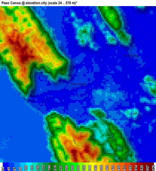
Below is the Elevation map of Paso Canoa, which displays elevation range with different colors. Scale of the first map is from 24 to 578 m (79 to 1896 ft) with average elevation of 137.4 meters (=451 ft) [note 1]
These maps also provides idea of topography and contour of this city, they are displayed at different zoom levels. More info about maps, scale and edge coordinates you can find below images.
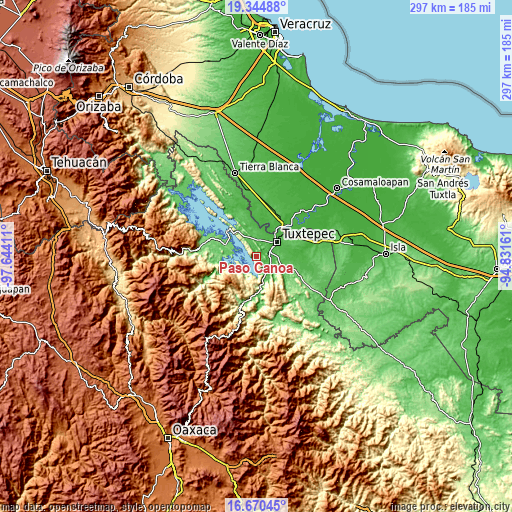
| \ | Map #1 | Topo.Map |
| Scale [m] | 24..578 m | × |
| Scale [ft] | 79..1896 ft | × |
| Average | 137.4 m = 451 ft | × |
| Width | 9.29 km = 5.8 mi | 297.4 km = 184.8 mi |
| Height | 9.29 km = 5.8 mi | 297.4 km = 184.8 mi |
| ↑Max Latitude | 18.054526° | 19.34488° |
| Latitude at center | 18.01274° | 18.01274° |
| ↓Min Latitude | 17.970944° | 16.67045° |
| ← Min Longitude | -96.281805° | -97.64411° |
| Longitude center | -96.23786° | -96.23786° |
| →Max Longitude | -96.193915° | -94.83161° |
Nearby cities:
Cities around Paso Canoa sort by population:
• Tuxtepec elevation 31 m
14.6 km,  54°
54°
• San Lucas Ojitlán 158 m
17.7 km,  286°
286°
• San José Chiltepec 53 m
10.2 km,  135°
135°
• San Bartolo 29 m
16.4 km,  57°
57°
• Papaloapan 26 m
22.4 km,  42°
42°
• Mazín Grande 74 m
13.8 km,  326°
326°
• Arroyo Choápam 53 m
9.7 km,  118°
118°
• Camelia Roja 46 m
3.6 km, 61°
• La Mina 50 m
14.9 km,  101°
101°
• Santa María Jacatepec 57 m
17.1 km,  170°
170°
• Cerro Armadillo Grande 629 m
17.9 km,  204°
204°
• Macín Chico 76 m
7.1 km, 329°
Multilingual:
 En español:
Raso Canoa, Paso Canoa elevación 53 m.
 En France:
Paso Canoa élévation 53 m.
 Auf Deutsch:
Paso Canoa höhe über dem Meeresspiegel ist 53 m.

Sources and notes:
- [note 1] Map square and city borders are not equal. Map elevation data is calculated only from area inside that square.
- [src 1] Elevation data from geonames database provided with same terms of usage.
- [src 2] The elevation map of Paso Canoa is generated using elevation data from NASA's 3 arcsec (90m) resolution SRTM data.
- [src 3] Base (background) map © OpenStreetMap contributors tiles are generated by Geofabrik and OpenTopoMap.
Copyright & License:
This Paso Canoa Elevation Map is licensed under CC BY-SA. You may reuse any part from this page, if you give a proper credit by linking to this URL:
 More info on terms of use page.