Macín Chico elevation
Macín Chico (Oaxaca, San Juan Bautista Tuxtepec), Mexico elevation is 76 meters and Macín Chico elevation in feet is 249 ft above sea level [src 1]. Macín Chico is a populated place (feature code) with elevation that is 1238 meters (4062 ft) smaller than average city elevation in Mexico.
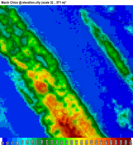
Below is the Elevation map of Macín Chico, which displays elevation range with different colors. Scale of the first map is from 32 to 571 m (105 to 1873 ft) with average elevation of 146.5 meters (=481 ft) [note 1]
These maps also provides idea of topography and contour of this city, they are displayed at different zoom levels. More info about maps, scale and edge coordinates you can find below images.
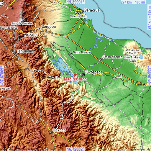
| \ | Map #1 | Topo.Map |
| Scale [m] | 32..571 m | × |
| Scale [ft] | 105..1873 ft | × |
| Average | 146.5 m = 481 ft | × |
| Width | 9.29 km = 5.8 mi | 297.3 km = 184.7 mi |
| Height | 9.29 km = 5.8 mi | 297.3 km = 184.7 mi |
| ↑Max Latitude | 18.109973° | 19.39991° |
| Latitude at center | 18.0682° | 18.0682° |
| ↓Min Latitude | 18.026417° | 16.72632° |
| ← Min Longitude | -96.315785° | -97.67809° |
| Longitude center | -96.27184° | -96.27184° |
| →Max Longitude | -96.227895° | -94.86559° |
Nearby cities:
Cities around Macín Chico sort by population:
• Tuxtepec elevation 31 m
15.6 km,  81°
81°
• San Lucas Ojitlán 158 m
13.4 km,  264°
264°
• San José Chiltepec 53 m
17.2 km,  141°
141°
• San Bartolo 29 m
17.6 km, 81°
• Piedra de Amolar 116 m
19.8 km,  286°
286°
• Mazín Grande 74 m
6.7 km,  323°
323°
• Arroyo Choápam 53 m
16.3 km,  131°
131°
• Camelia Roja 46 m
8.1 km,  123°
123°
• Arroyo Chical (Nuevo Arroyo Chicali) 72 m
17.8 km,  337°
337°
• Paso Canoa 53 m
7.1 km,  149°
149°
• El Capulín (La Nueva Pochota) 44 m
18 km,  357°
357°
• Corral de Piedra 61 m
20 km,  349°
349°
Multilingual:
 En español:
Mazín Chico elevación 76 m.
 En France:
Macín Chico élévation 76 m.
 Auf Deutsch:
Macín Chico höhe über dem Meeresspiegel ist 76 m.

Sources and notes:
- [note 1] Map square and city borders are not equal. Map elevation data is calculated only from area inside that square.
- [src 1] Elevation data from geonames database provided with same terms of usage.
- [src 2] The elevation map of Macín Chico is generated using elevation data from NASA's 3 arcsec (90m) resolution SRTM data.
- [src 3] Base (background) map © OpenStreetMap contributors tiles are generated by Geofabrik and OpenTopoMap.
Copyright & License:
This Macín Chico Elevation Map is licensed under CC BY-SA. You may reuse any part from this page, if you give a proper credit by linking to this URL:
 More info on terms of use page.