San Lucas Ojitlán elevation
San Lucas Ojitlán (Oaxaca), Mexico elevation is 158 meters and San Lucas Ojitlán elevation in feet is 518 ft above sea level [src 1]. San Lucas Ojitlán is a populated place (feature code) with elevation that is 1156 meters (3793 ft) smaller than average city elevation in Mexico.
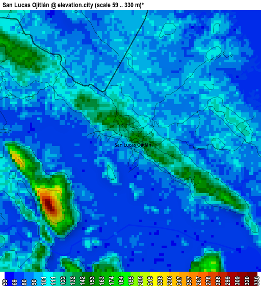
Below is the Elevation map of San Lucas Ojitlán, which displays elevation range with different colors. Scale of the first map is from 59 to 330 m (194 to 1083 ft) with average elevation of 95.5 meters (=313 ft) [note 1]
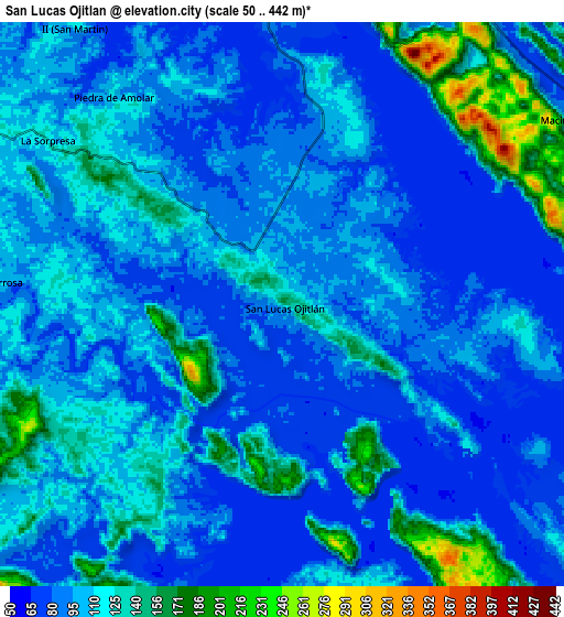
These maps also provides idea of topography and contour of this city, they are displayed at different zoom levels. More info about maps, scale and edge coordinates you can find below images.
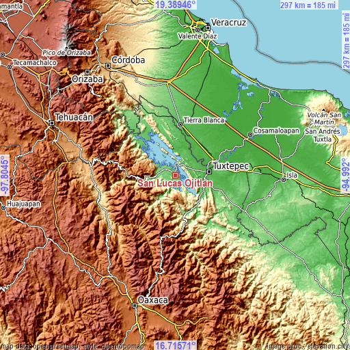
| \ | Map #1 | Map #2 | Topo.Map |
| Scale [m] | 59..330 m | 50..442 m | × |
| Scale [ft] | 194..1083 ft | 164..1450 ft | × |
| Average | 95.5 m = 313 ft | 105.4 m = 346 ft | × |
| Width | 9.29 km = 5.8 mi | 18.58 km = 11.5 mi | 297.3 km = 184.7 mi |
| Height | 9.29 km = 5.8 mi | 18.58 km = 11.5 mi | 297.3 km = 184.7 mi |
| ↑Max Latitude | 18.099446° | 18.141212° | 19.38946° |
| Latitude at center | 18.05767° | 18.05767° | 18.05767° |
| ↓Min Latitude | 18.015884° | 17.974089° | 16.71571° |
| ← Min Longitude | -96.442195° | -96.486141° | -97.8045° |
| Longitude center | -96.39825° | -96.39825° | -96.39825° |
| →Max Longitude | -96.354305° | -96.310359° | -94.992° |
Nearby cities:
Cities around San Lucas Ojitlán sort by population:
• San Felipe Jalapa de Díaz elevation 148 m
14.6 km,  275°
275°
• San Pedro Ixcatlán 91 m
15.3 km,  309°
309°
• Piedra de Amolar 116 m
8.9 km,  321°
321°
• Mazín Grande 74 m
11.4 km,  55°
55°
• Benito Juárez II (San Martín) 120 m
11.4 km, 324°
• Santo Tomás 208 m
12.3 km,  261°
261°
• Flor Batavia 452 m
15.1 km,  237°
237°
• Playa Chica 94 m
12.7 km,  271°
271°
• Macín Chico 76 m
13.4 km,  84°
84°
• Arroyo Zapotillo 124 m
15.6 km, 277°
• Paso Canoa 53 m
17.7 km,  106°
106°
• Colonia la Central 105 m
12.9 km, 284°
Multilingual:
 En español:
San Lucas Ojitlán elevación 158 m.
 En France:
San Lucas Ojitlán élévation 158 m.
 Auf Deutsch:
San Lucas Ojitlán höhe über dem Meeresspiegel ist 158 m.

Sources and notes:
- [note 1] Map square and city borders are not equal. Map elevation data is calculated only from area inside that square.
- [src 1] Elevation data from geonames database provided with same terms of usage.
- [src 2] The elevation map of San Lucas Ojitlán is generated using elevation data from NASA's 3 arcsec (90m) resolution SRTM data.
- [src 3] Base (background) map © OpenStreetMap contributors tiles are generated by Geofabrik and OpenTopoMap.
Copyright & License:
This San Lucas Ojitlán Elevation Map is licensed under CC BY-SA. You may reuse any part from this page, if you give a proper credit by linking to this URL:
 More info on terms of use page.