Zapotitlán Lagunas elevation
Zapotitlán Lagunas (Oaxaca), Mexico elevation is 1558 meters and Zapotitlán Lagunas elevation in feet is 5112 ft above sea level [src 1]. Zapotitlán Lagunas is a populated place (feature code) with elevation that is 244 meters (801 ft) bigger than average city elevation in Mexico.
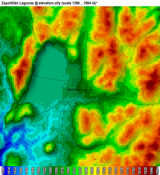
Below is the Elevation map of Zapotitlán Lagunas, which displays elevation range with different colors. Scale of the first map is from 1396 to 1864 m (4580 to 6115 ft) with average elevation of 1624.2 meters (=5329 ft) [note 1]
These maps also provides idea of topography and contour of this city, they are displayed at different zoom levels. More info about maps, scale and edge coordinates you can find below images.
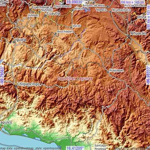
| \ | Map #1 | Topo.Map |
| Scale [m] | 1396..1864 m | × |
| Scale [ft] | 4580..6115 ft | × |
| Average | 1624.2 m = 5329 ft | × |
| Width | 9.31 km = 5.8 mi | 297.8 km = 185 mi |
| Height | 9.31 km = 5.8 mi | 297.8 km = 185 mi |
| ↑Max Latitude | 17.798057° | 19.09035° |
| Latitude at center | 17.75621° | 17.75621° |
| ↓Min Latitude | 17.714353° | 16.41205° |
| ← Min Longitude | -98.433525° | -99.79583° |
| Longitude center | -98.38958° | -98.38958° |
| →Max Longitude | -98.345635° | -96.98333° |
Nearby cities:
Cities around Zapotitlán Lagunas sort by population:
• Huamuxtitlán elevation 894 m
19.2 km,  286°
286°
• Xochihuehuetlán 1041 m
19.7 km,  327°
327°
• Alpoyeca 965 m
15.9 km,  233°
233°
• Tlalixtaquilla 1150 m
20.1 km,  173°
173°
• Ahuehuetitlán 1378 m
12 km,  142°
142°
• Tlaquiltepec 931 m
16.9 km,  260°
260°
• Coyahualco 914 m
18.8 km, 264°
• Santa Cruz 900 m
19.2 km,  273°
273°
• San Mateo Nejápam 1355 m
11.5 km,  194°
194°
• Tlachichilco 1327 m
15.7 km,  161°
161°
• Tepetlapa 1476 m
10 km,  181°
181°
• San Juan Ihualtepec 1789 m
10.8 km,  99°
99°
Multilingual:
 En español:
Zapotitlán Lagunas elevación 1558 m.
 En France:
Zapotitlán Lagunas élévation 1558 m.
 Auf Deutsch:
Zapotitlán Lagunas höhe über dem Meeresspiegel ist 1558 m.
 На русском:
Zapotitlán Lagunas высота над уровнем моря 1558 м
Sources and notes:
- [note 1] Map square and city borders are not equal. Map elevation data is calculated only from area inside that square.
- [src 1] Elevation data from geonames database provided with same terms of usage.
- [src 2] The elevation map of Zapotitlán Lagunas is generated using elevation data from NASA's 3 arcsec (90m) resolution SRTM data.
- [src 3] Base (background) map © OpenStreetMap contributors tiles are generated by Geofabrik and OpenTopoMap.
Copyright & License:
This Zapotitlán Lagunas Elevation Map is licensed under CC BY-SA. You may reuse any part from this page, if you give a proper credit by linking to this URL:
 More info on terms of use page.