Alpoyeca elevation
Alpoyeca (Guerrero), Mexico elevation is 965 meters and Alpoyeca elevation in feet is 3166 ft above sea level [src 1]. Alpoyeca is a seat of a second-order administrative division (feature code) with elevation that is 349 meters (1145 ft) smaller than average city elevation in Mexico.
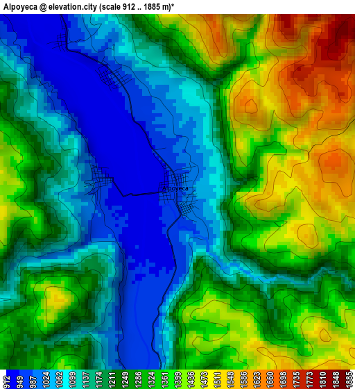
Below is the Elevation map of Alpoyeca, which displays elevation range with different colors. Scale of the first map is from 912 to 1885 m (2992 to 6184 ft) with average elevation of 1240.4 meters (=4070 ft) [note 1]
These maps also provides idea of topography and contour of this city, they are displayed at different zoom levels. More info about maps, scale and edge coordinates you can find below images.
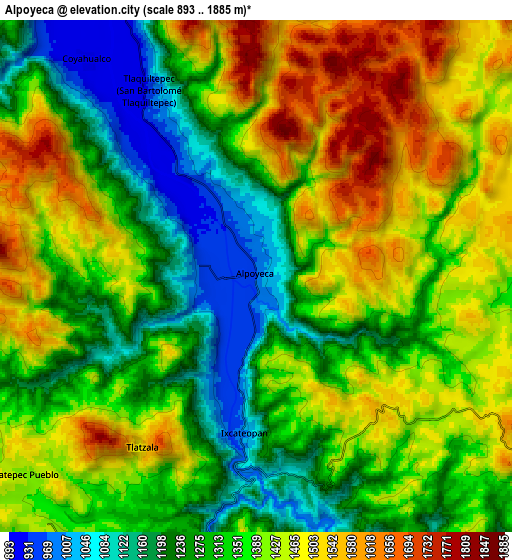
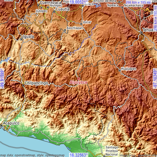
| \ | Map #1 | Map #2 | Topo.Map |
| Scale [m] | 912..1885 m | 893..1885 m | × |
| Scale [ft] | 2992..6184 ft | 2930..6184 ft | × |
| Average | 1240.4 m = 4070 ft | 1363.3 m = 4473 ft | × |
| Width | 9.31 km = 5.8 mi | 18.62 km = 11.6 mi | 297.9 km = 185.1 mi |
| Height | 9.31 km = 5.8 mi | 18.62 km = 11.6 mi | 298 km = 185.2 mi |
| ↑Max Latitude | 17.712277° | 17.754134° | 19.00521° |
| Latitude at center | 17.67041° | 17.67041° | 17.67041° |
| ↓Min Latitude | 17.628533° | 17.586647° | 16.32563° |
| ← Min Longitude | -98.553685° | -98.597631° | -99.91599° |
| Longitude center | -98.50974° | -98.50974° | -98.50974° |
| →Max Longitude | -98.465795° | -98.421849° | -97.10349° |
Nearby cities:
Cities around Alpoyeca sort by population:
• Tlapa de Comonfort elevation 1092 m
15.6 km,  206°
206°
• Huamuxtitlán 894 m
16 km,  338°
338°
• Atlamajac 1061 m
13.4 km,  197°
197°
• Zapotitlán Lagunas 1558 m
15.9 km,  53°
53°
• Ixcateopan 1000 m
5.8 km,  184°
184°
• Tlatzala 1498 m
7.5 km, 214°
• Ahuatepec Pueblo 1414 m
11.1 km,  229°
229°
• Tlaquiltepec 931 m
7.9 km,  329°
329°
• Coyahualco 914 m
9.9 km,  322°
322°
• Santa Cruz 900 m
12.6 km, 329°
• San Mateo Nejápam 1355 m
10 km,  99°
99°
• Tepetlapa 1476 m
12.5 km,  92°
92°
Multilingual:
 En español:
Alpoyeca elevación 965 m.
 En France:
Alpoyeca élévation 965 m.
 Auf Deutsch:
Alpoyeca höhe über dem Meeresspiegel ist 965 m.

Sources and notes:
- [note 1] Map square and city borders are not equal. Map elevation data is calculated only from area inside that square.
- [src 1] Elevation data from geonames database provided with same terms of usage.
- [src 2] The elevation map of Alpoyeca is generated using elevation data from NASA's 3 arcsec (90m) resolution SRTM data.
- [src 3] Base (background) map © OpenStreetMap contributors tiles are generated by Geofabrik and OpenTopoMap.
Copyright & License:
This Alpoyeca Elevation Map is licensed under CC BY-SA. You may reuse any part from this page, if you give a proper credit by linking to this URL:
 More info on terms of use page.