Tepetlapa elevation
Tepetlapa (Oaxaca, San Andrés Tepetlapa), Mexico elevation is 1476 meters and Tepetlapa elevation in feet is 4843 ft above sea level [src 1]. Tepetlapa is a seat of a second-order administrative division (feature code) with elevation that is 162 meters (531 ft) bigger than average city elevation in Mexico.
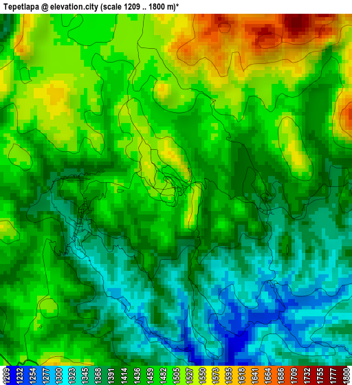
Below is the Elevation map of Tepetlapa, which displays elevation range with different colors. Scale of the first map is from 1209 to 1800 m (3967 to 5906 ft) with average elevation of 1444.5 meters (=4739 ft) [note 1]
These maps also provides idea of topography and contour of this city, they are displayed at different zoom levels. More info about maps, scale and edge coordinates you can find below images.
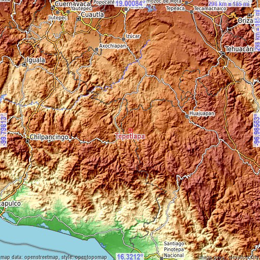
| \ | Map #1 | Topo.Map |
| Scale [m] | 1209..1800 m | × |
| Scale [ft] | 3967..5906 ft | × |
| Average | 1444.5 m = 4739 ft | × |
| Width | 9.31 km = 5.8 mi | 297.9 km = 185.1 mi |
| Height | 9.31 km = 5.8 mi | 298 km = 185.2 mi |
| ↑Max Latitude | 17.707878° | 19.00084° |
| Latitude at center | 17.66601° | 17.66601° |
| ↓Min Latitude | 17.624132° | 16.3212° |
| ← Min Longitude | -98.435825° | -99.79813° |
| Longitude center | -98.39188° | -98.39188° |
| →Max Longitude | -98.347935° | -96.98563° |
Nearby cities:
Cities around Tepetlapa sort by population:
• Alpoyeca elevation 965 m
12.5 km,  272°
272°
• Tlalixtaquilla 1150 m
10.3 km,  165°
165°
• Ahuehuetitlán 1378 m
7.6 km,  85°
85°
• Zapotitlán Lagunas 1558 m
10 km,  1°
1°
• Ixcateopan 1000 m
14 km,  247°
247°
• Tlatzala 1498 m
17.7 km, 251°
• Tlaquiltepec 931 m
18 km,  293°
293°
• Santa Cruz 1660 m
14.8 km,  184°
184°
• La Luz de Juárez 1400 m
15.3 km,  162°
162°
• San Mateo Nejápam 1355 m
2.8 km, 247°
• Tlachichilco 1327 m
7.1 km,  133°
133°
• San Juan Ihualtepec 1789 m
13.7 km,  52°
52°
Multilingual:
 En español:
Tepetlapa elevación 1476 m.
 En France:
Tepetlapa élévation 1476 m.
 Auf Deutsch:
Tepetlapa höhe über dem Meeresspiegel ist 1476 m.

Sources and notes:
- [note 1] Map square and city borders are not equal. Map elevation data is calculated only from area inside that square.
- [src 1] Elevation data from geonames database provided with same terms of usage.
- [src 2] The elevation map of Tepetlapa is generated using elevation data from NASA's 3 arcsec (90m) resolution SRTM data.
- [src 3] Base (background) map © OpenStreetMap contributors tiles are generated by Geofabrik and OpenTopoMap.
Copyright & License:
This Tepetlapa Elevation Map is licensed under CC BY-SA. You may reuse any part from this page, if you give a proper credit by linking to this URL:
 More info on terms of use page.