Xochihuehuetlán elevation
Xochihuehuetlán (Guerrero), Mexico elevation is 1041 meters and Xochihuehuetlán elevation in feet is 3415 ft above sea level [src 1]. Xochihuehuetlán is a seat of a second-order administrative division (feature code) with elevation that is 273 meters (896 ft) smaller than average city elevation in Mexico.
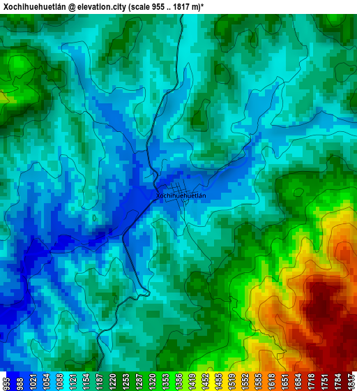
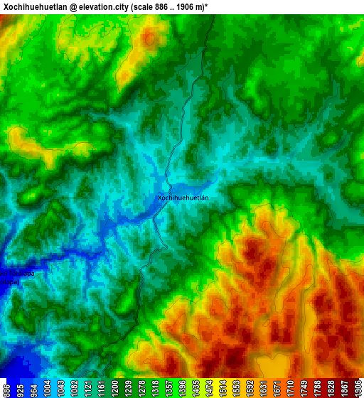
Below is the Elevation map of Xochihuehuetlán, which displays elevation range with different colors. Scale of the first map is from 955 to 1817 m (3133 to 5961 ft) with average elevation of 1192.2 meters (=3911 ft) [note 1]
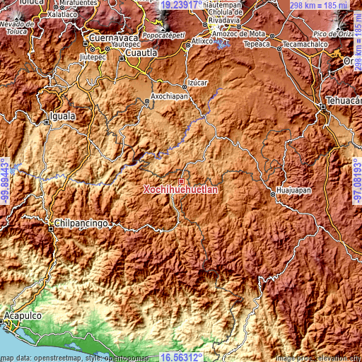
These maps also provides idea of topography and contour of this city, they are displayed at different zoom levels. More info about maps, scale and edge coordinates you can find below images.
| \ | Map #1 | Map #2 | Topo.Map |
| Scale [m] | 955..1817 m | 886..1906 m | × |
| Scale [ft] | 3133..5961 ft | 2907..6253 ft | × |
| Average | 1192.2 m = 3911 ft | 1303.9 m = 4278 ft | × |
| Width | 9.3 km = 5.8 mi | 18.6 km = 11.6 mi | 297.5 km = 184.9 mi |
| Height | 9.3 km = 5.8 mi | 18.6 km = 11.6 mi | 297.6 km = 184.9 mi |
| ↑Max Latitude | 17.948002° | 17.989804° | 19.23917° |
| Latitude at center | 17.90619° | 17.90619° | 17.90619° |
| ↓Min Latitude | 17.864368° | 17.822537° | 16.56312° |
| ← Min Longitude | -98.532125° | -98.576071° | -99.89443° |
| Longitude center | -98.48818° | -98.48818° | -98.48818° |
| →Max Longitude | -98.444235° | -98.400289° | -97.08193° |
Nearby cities:
Cities around Xochihuehuetlán sort by population:
• Huamuxtitlán elevation 894 m
13.9 km,  215°
215°
• Tulcingo de Valle 1102 m
16.1 km,  18°
18°
• Acaxtlahuacán de Albino Zertuche 1273 m
13.5 km,  335°
335°
• San Antonio Coyahuacán 1546 m
20.9 km,  256°
256°
• Zapotitlán Lagunas 1558 m
19.7 km,  147°
147°
• Tlaquiltepec 931 m
20.4 km,  197°
197°
• Zumpango 1172 m
20.9 km,  278°
278°
• Coyahualco 914 m
20.1 km, 204°
• Progreso 949 m
23.7 km,  52°
52°
• Santa Cruz 900 m
17.7 km,  209°
209°
• Chila de la Sal 945 m
22.6 km,  0°
0°
• Xicotlán 1279 m
17.4 km,  347°
347°
Multilingual:
 En español:
Xochihuehuetlán elevación 1041 m.
 En France:
Xochihuehuetlán élévation 1041 m.
 Auf Deutsch:
Xochihuehuetlán höhe über dem Meeresspiegel ist 1041 m.

Sources and notes:
- [note 1] Map square and city borders are not equal. Map elevation data is calculated only from area inside that square.
- [src 1] Elevation data from geonames database provided with same terms of usage.
- [src 2] The elevation map of Xochihuehuetlán is generated using elevation data from NASA's 3 arcsec (90m) resolution SRTM data.
- [src 3] Base (background) map © OpenStreetMap contributors tiles are generated by Geofabrik and OpenTopoMap.
Copyright & License:
This Xochihuehuetlán Elevation Map is licensed under CC BY-SA. You may reuse any part from this page, if you give a proper credit by linking to this URL:
 More info on terms of use page.