Progreso elevation
Progreso (Puebla, Piaxtla), Mexico elevation is 949 meters and Progreso elevation in feet is 3114 ft above sea level [src 1]. Progreso is a populated place (feature code) with elevation that is 365 meters (1198 ft) smaller than average city elevation in Mexico.
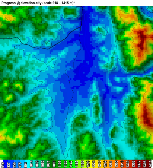
Below is the Elevation map of Progreso, which displays elevation range with different colors. Scale of the first map is from 918 to 1415 m (3012 to 4642 ft) with average elevation of 1042.8 meters (=3421 ft) [note 1]
These maps also provides idea of topography and contour of this city, they are displayed at different zoom levels. More info about maps, scale and edge coordinates you can find below images.
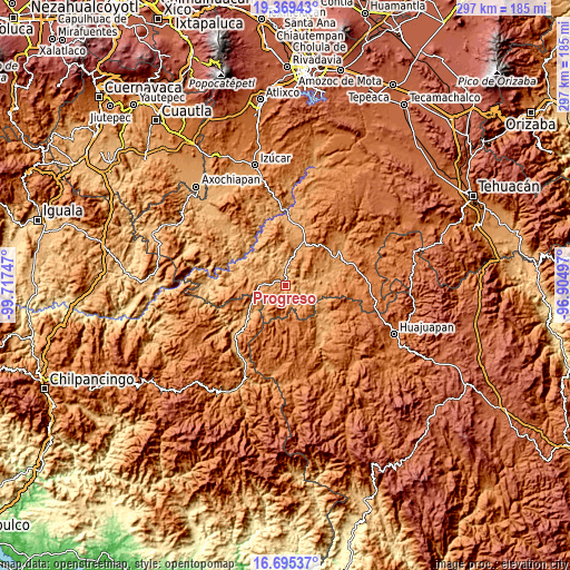
| \ | Map #1 | Topo.Map |
| Scale [m] | 918..1415 m | × |
| Scale [ft] | 3012..4642 ft | × |
| Average | 1042.8 m = 3421 ft | × |
| Width | 9.29 km = 5.8 mi | 297.3 km = 184.7 mi |
| Height | 9.29 km = 5.8 mi | 297.3 km = 184.7 mi |
| ↑Max Latitude | 18.079261° | 19.36943° |
| Latitude at center | 18.03748° | 18.03748° |
| ↓Min Latitude | 17.995689° | 16.69537° |
| ← Min Longitude | -98.355165° | -99.71747° |
| Longitude center | -98.31122° | -98.31122° |
| →Max Longitude | -98.267275° | -96.90497° |
Nearby cities:
Cities around Progreso sort by population:
• Tulcingo de Valle elevation 1102 m
13.7 km,  272°
272°
• Xochihuehuetlán 1041 m
23.7 km,  232°
232°
• Tecomatlán 922 m
8 km,  358°
358°
• Guadalupe Santa Ana 1104 m
21 km,  73°
73°
• San Pablo Anicano 1135 m
25.8 km, 68°
• Acaxtlahuacán de Albino Zertuche 1273 m
24.3 km,  264°
264°
• Chinantla 1110 m
18.9 km,  15°
15°
• Piaxtla 1112 m
19 km, 18°
• Ahuehuetitla 1201 m
21.8 km,  26°
26°
• Chila de la Sal 945 m
20.1 km,  293°
293°
• Xicotlán 1279 m
22.7 km,  276°
276°
• Axutla 888 m
18.8 km,  333°
333°
Multilingual:
 En español:
Progreso elevación 949 m.
 En France:
Progreso élévation 949 m.
 Auf Deutsch:
Progreso höhe über dem Meeresspiegel ist 949 m.

Sources and notes:
- [note 1] Map square and city borders are not equal. Map elevation data is calculated only from area inside that square.
- [src 1] Elevation data from geonames database provided with same terms of usage.
- [src 2] The elevation map of Progreso is generated using elevation data from NASA's 3 arcsec (90m) resolution SRTM data.
- [src 3] Base (background) map © OpenStreetMap contributors tiles are generated by Geofabrik and OpenTopoMap.
Copyright & License:
This Progreso Elevation Map is licensed under CC BY-SA. You may reuse any part from this page, if you give a proper credit by linking to this URL:
 More info on terms of use page.