Axutla elevation
Axutla (Puebla), Mexico elevation is 888 meters and Axutla elevation in feet is 2913 ft above sea level [src 1]. Axutla is a seat of a second-order administrative division (feature code) with elevation that is 426 meters (1398 ft) smaller than average city elevation in Mexico.
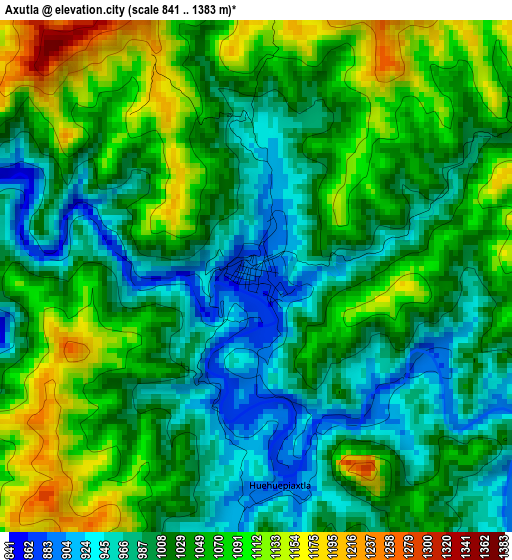
Below is the Elevation map of Axutla, which displays elevation range with different colors. Scale of the first map is from 841 to 1383 m (2759 to 4537 ft) with average elevation of 1031.6 meters (=3385 ft) [note 1]
These maps also provides idea of topography and contour of this city, they are displayed at different zoom levels. More info about maps, scale and edge coordinates you can find below images.
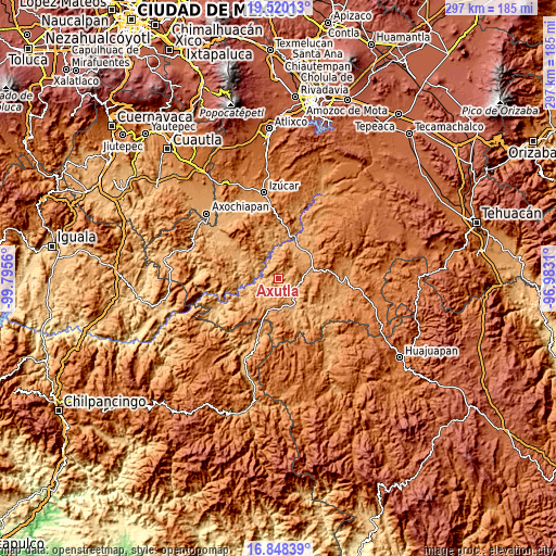
| \ | Map #1 | Topo.Map |
| Scale [m] | 841..1383 m | × |
| Scale [ft] | 2759..4537 ft | × |
| Average | 1031.6 m = 3385 ft | × |
| Width | 9.28 km = 5.8 mi | 297.1 km = 184.6 mi |
| Height | 9.28 km = 5.8 mi | 297.1 km = 184.6 mi |
| ↑Max Latitude | 18.231124° | 19.52013° |
| Latitude at center | 18.18938° | 18.18938° |
| ↓Min Latitude | 18.147626° | 16.84839° |
| ← Min Longitude | -98.433295° | -99.7956° |
| Longitude center | -98.38935° | -98.38935° |
| →Max Longitude | -98.345405° | -96.9831° |
Nearby cities:
Cities around Axutla sort by population:
• Chiautla de Tapia elevation 1022 m
25.8 km,  298°
298°
• Ciudad de Chiautla de Tapia 1019 m
25.8 km, 298°
• Tehuitzingo 1074 m
19.9 km,  37°
37°
• Tulcingo de Valle 1102 m
17.1 km,  198°
198°
• Tecomatlán 922 m
12 km,  137°
137°
• Acaxtlahuacán de Albino Zertuche 1273 m
24.9 km,  219°
219°
• Chinantla 1110 m
13.3 km,  84°
84°
• Piaxtla 1112 m
14.3 km,  85°
85°
• Ahuehuetitla 1201 m
18.1 km, 81°
• Progreso 949 m
18.8 km,  153°
153°
• Chila de la Sal 945 m
13.5 km,  228°
228°
• Xicotlán 1279 m
20.3 km, 224°
Multilingual:
 En español:
Axutla elevación 888 m.
 En France:
Axutla élévation 888 m.


Sources and notes:
- [note 1] Map square and city borders are not equal. Map elevation data is calculated only from area inside that square.
- [src 1] Elevation data from geonames database provided with same terms of usage.
- [src 2] The elevation map of Axutla is generated using elevation data from NASA's 3 arcsec (90m) resolution SRTM data.
- [src 3] Base (background) map © OpenStreetMap contributors tiles are generated by Geofabrik and OpenTopoMap.
Copyright & License:
This Axutla Elevation Map is licensed under CC BY-SA. You may reuse any part from this page, if you give a proper credit by linking to this URL:
 More info on terms of use page.