Santa María Lachixío elevation
Santa María Lachixío (Oaxaca), Mexico elevation is 2251 meters and Santa María Lachixío elevation in feet is 7385 ft above sea level [src 1]. Santa María Lachixío is a populated place (feature code) with elevation that is 937 meters (3074 ft) bigger than average city elevation in Mexico.
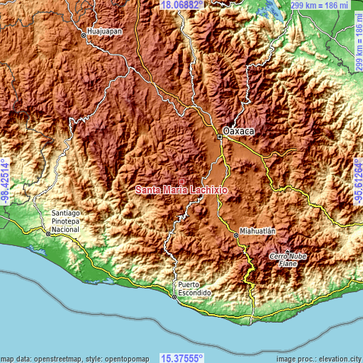
Below is the Elevation map of Santa María Lachixío, which displays elevation range with different colors. Scale of the first map is from 1819 to 2917 m (5968 to 9570 ft) with average elevation of 2404.7 meters (=7889 ft) [note 1]
These maps also provides idea of topography and contour of this city, they are displayed at different zoom levels. More info about maps, scale and edge coordinates you can find below images.

| \ | Map #1 | Topo.Map |
| Scale [m] | 1819..2917 m | × |
| Scale [ft] | 5968..9570 ft | × |
| Average | 2404.7 m = 7889 ft | × |
| Width | 9.36 km = 5.8 mi | 299.5 km = 186.1 mi |
| Height | 9.36 km = 5.8 mi | 299.5 km = 186.1 mi |
| ↑Max Latitude | 16.769021° | 18.06882° |
| Latitude at center | 16.72694° | 16.72694° |
| ↓Min Latitude | 16.684849° | 15.37555° |
| ← Min Longitude | -97.062835° | -98.42514° |
| Longitude center | -97.01889° | -97.01889° |
| →Max Longitude | -96.974945° | -95.61264° |
Nearby cities:
Cities around Santa María Lachixío sort by population:
• Ayoquezco de Aldama elevation 1451 m
19.4 km,  104°
104°
• Villa Sola de Vega 1443 m
23.6 km,  169°
169°
• San Bernardo Mixtepec 1651 m
16.8 km,  49°
49°
• Santa Cruz Mixtepec 1595 m
16.4 km,  63°
63°
• San Vicente Lachixío 2203 m
2.4 km,  179°
179°
• San Miguel Peras 2086 m
23.6 km,  1°
1°
• Valdeflores 1478 m
21.2 km,  78°
78°
• San Martín Lachila 1431 m
22.2 km,  125°
125°
• Santa Ana Tlapacoyan 1484 m
19.5 km, 84°
• San Miguel Mixtepec 1978 m
8.6 km, 49°
• Magdalena Mixtepec 2019 m
22.4 km,  32°
32°
• Santa María Sola 1450 m
17.9 km, 177°
Multilingual:
 En español:
San Vicente Lachixlo elevación 2251 m.
 En France:
Santa María Lachixío élévation 2251 m.
 Auf Deutsch:
Santa María Lachixío höhe über dem Meeresspiegel ist 2251 m.
 На русском:
Santa María Lachixío высота над уровнем моря 2251 м
Sources and notes:
- [note 1] Map square and city borders are not equal. Map elevation data is calculated only from area inside that square.
- [src 1] Elevation data from geonames database provided with same terms of usage.
- [src 2] The elevation map of Santa María Lachixío is generated using elevation data from NASA's 3 arcsec (90m) resolution SRTM data.
- [src 3] Base (background) map © OpenStreetMap contributors tiles are generated by Geofabrik and OpenTopoMap.
Copyright & License:
This Santa María Lachixío Elevation Map is licensed under CC BY-SA. You may reuse any part from this page, if you give a proper credit by linking to this URL:
 More info on terms of use page.