San Martín Lachila elevation
San Martín Lachila (Oaxaca, San Martín Lachilá), Mexico elevation is 1431 meters and San Martín Lachila elevation in feet is 4695 ft above sea level [src 1]. San Martín Lachila is a populated place (feature code) with elevation that is 117 meters (384 ft) bigger than average city elevation in Mexico.
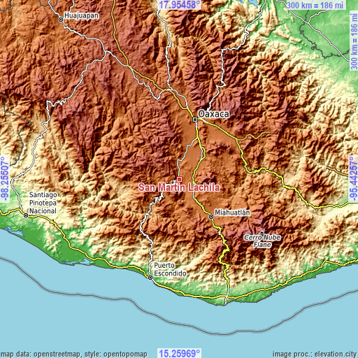
Below is the Elevation map of San Martín Lachila, which displays elevation range with different colors. Scale of the first map is from 1405 to 2260 m (4610 to 7415 ft) with average elevation of 1583.8 meters (=5196 ft) [note 1]
These maps also provides idea of topography and contour of this city, they are displayed at different zoom levels. More info about maps, scale and edge coordinates you can find below images.

| \ | Map #1 | Topo.Map |
| Scale [m] | 1405..2260 m | × |
| Scale [ft] | 4610..7415 ft | × |
| Average | 1583.8 m = 5196 ft | × |
| Width | 9.36 km = 5.8 mi | 299.6 km = 186.2 mi |
| Height | 9.36 km = 5.8 mi | 299.7 km = 186.2 mi |
| ↑Max Latitude | 16.653967° | 17.95458° |
| Latitude at center | 16.61186° | 16.61186° |
| ↓Min Latitude | 16.569744° | 15.25969° |
| ← Min Longitude | -96.892765° | -98.25507° |
| Longitude center | -96.84882° | -96.84882° |
| →Max Longitude | -96.804875° | -95.44257° |
Nearby cities:
Cities around San Martín Lachila sort by population:
• Ejutla de Crespo elevation 1448 m
13.5 km,  112°
112°
• Ayoquezco de Aldama 1451 m
8 km,  4°
4°
• La Pe 1475 m
5.8 km,  69°
69°
• Santa Martha Chichihualtepec 1492 m
9 km,  62°
62°
• San Agustín Amatengo 1366 m
12.9 km,  150°
150°
• Agua del Espino 1434 m
5.5 km,  115°
115°
• Valdeflores 1478 m
17.3 km,  8°
8°
• San Francisco Sola 1419 m
17.2 km,  231°
231°
• Santa Ana Tlapacoyan 1484 m
14.7 km, 4°
• San Martín de los Canseco 1530 m
13.8 km, 68°
• San Miguel Ejutla 1454 m
12.2 km, 106°
• Taniche 1412 m
11.1 km, 115°
Multilingual:
 En español:
San Martín Lachila elevación 1431 m.
 En France:
San Martín Lachila élévation 1431 m.
 Auf Deutsch:
San Martín Lachila höhe über dem Meeresspiegel ist 1431 m.
 На русском:
San Martín Lachila высота над уровнем моря 1431 м
Sources and notes:
- [note 1] Map square and city borders are not equal. Map elevation data is calculated only from area inside that square.
- [src 1] Elevation data from geonames database provided with same terms of usage.
- [src 2] The elevation map of San Martín Lachila is generated using elevation data from NASA's 3 arcsec (90m) resolution SRTM data.
- [src 3] Base (background) map © OpenStreetMap contributors tiles are generated by Geofabrik and OpenTopoMap.
Copyright & License:
This San Martín Lachila Elevation Map is licensed under CC BY-SA. You may reuse any part from this page, if you give a proper credit by linking to this URL:
 More info on terms of use page.