Magdalena Mixtepec elevation
Magdalena Mixtepec (Oaxaca), Mexico elevation is 2019 meters and Magdalena Mixtepec elevation in feet is 6624 ft above sea level [src 1]. Magdalena Mixtepec is a seat of a second-order administrative division (feature code) with elevation that is 705 meters (2313 ft) bigger than average city elevation in Mexico.
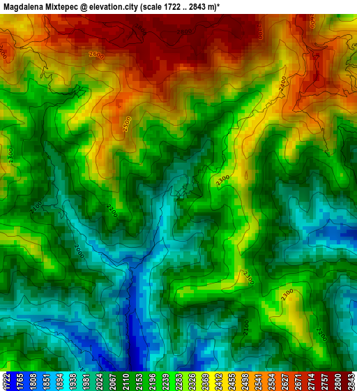
Below is the Elevation map of Magdalena Mixtepec, which displays elevation range with different colors. Scale of the first map is from 1722 to 2843 m (5650 to 9327 ft) with average elevation of 2229.2 meters (=7314 ft) [note 1]
These maps also provides idea of topography and contour of this city, they are displayed at different zoom levels. More info about maps, scale and edge coordinates you can find below images.
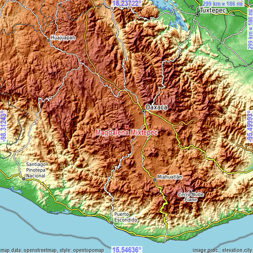
| \ | Map #1 | Topo.Map |
| Scale [m] | 1722..2843 m | × |
| Scale [ft] | 5650..9327 ft | × |
| Average | 2229.2 m = 7314 ft | × |
| Width | 9.35 km = 5.8 mi | 299.2 km = 185.9 mi |
| Height | 9.35 km = 5.8 mi | 299.2 km = 185.9 mi |
| ↑Max Latitude | 16.938634° | 18.23722° |
| Latitude at center | 16.89659° | 16.89659° |
| ↓Min Latitude | 16.854537° | 15.54636° |
| ← Min Longitude | -96.950125° | -98.31243° |
| Longitude center | -96.90618° | -96.90618° |
| →Max Longitude | -96.862235° | -95.49993° |
Nearby cities:
Cities around Magdalena Mixtepec sort by population:
• Zimatlán de Álvarez elevation 1505 m
13.3 km,  103°
103°
• San Pablo Huixtepec 1485 m
15.8 km,  122°
122°
• Ciénega de Zimatlán 1501 m
14.8 km,  91°
91°
• Fraccionamiento Real del Valle 1515 m
15.3 km,  74°
74°
• San Bernardo Mixtepec 1651 m
7.9 km,  174°
174°
• Santa Cruz Mixtepec 1595 m
11.9 km, 166°
• San Miguel Peras 2086 m
12.1 km,  292°
292°
• San Nicolás Quialana 1488 m
14.8 km,  113°
113°
• Trinidad Zaachila 1510 m
15.4 km,  79°
79°
• San Miguel Mixtepec 1978 m
14.3 km,  202°
202°
• Santa Inés del Monte 2426 m
5.6 km,  56°
56°
• San Pablo Cuatro Venados 2491 m
9.5 km,  9°
9°
Multilingual:
 En español:
Magdalena Mixtepec elevación 2019 m.
 En France:
Magdalena Mixtepec élévation 2019 m.
 Auf Deutsch:
Magdalena Mixtepec höhe über dem Meeresspiegel ist 2019 m.
 На русском:
Magdalena Mixtepec высота над уровнем моря 2019 м
Sources and notes:
- [note 1] Map square and city borders are not equal. Map elevation data is calculated only from area inside that square.
- [src 1] Elevation data from geonames database provided with same terms of usage.
- [src 2] The elevation map of Magdalena Mixtepec is generated using elevation data from NASA's 3 arcsec (90m) resolution SRTM data.
- [src 3] Base (background) map © OpenStreetMap contributors tiles are generated by Geofabrik and OpenTopoMap.
Copyright & License:
This Magdalena Mixtepec Elevation Map is licensed under CC BY-SA. You may reuse any part from this page, if you give a proper credit by linking to this URL:
 More info on terms of use page.