Zimatlán de Álvarez elevation
Zimatlán de Álvarez (Oaxaca), Mexico elevation is 1505 meters and Zimatlán de Álvarez elevation in feet is 4938 ft above sea level [src 1]. Zimatlán de Álvarez is a seat of a second-order administrative division (feature code) with elevation that is 191 meters (627 ft) bigger than average city elevation in Mexico.
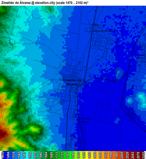
Below is the Elevation map of Zimatlán de Álvarez, which displays elevation range with different colors. Scale of the first map is from 1470 to 2102 m (4823 to 6896 ft) with average elevation of 1547.1 meters (=5076 ft) [note 1]
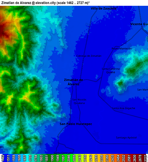
These maps also provides idea of topography and contour of this city, they are displayed at different zoom levels. More info about maps, scale and edge coordinates you can find below images.
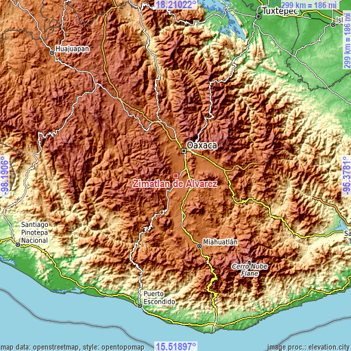
| \ | Map #1 | Map #2 | Topo.Map |
| Scale [m] | 1470..2102 m | 1462..2727 m | × |
| Scale [ft] | 4823..6896 ft | 4797..8947 ft | × |
| Average | 1547.1 m = 5076 ft | 1637.3 m = 5372 ft | × |
| Width | 9.35 km = 5.8 mi | 18.7 km = 11.6 mi | 299.2 km = 185.9 mi |
| Height | 9.35 km = 5.8 mi | 18.7 km = 11.6 mi | 299.3 km = 186 mi |
| ↑Max Latitude | 16.91144° | 16.95348° | 18.21022° |
| Latitude at center | 16.86939° | 16.86939° | 16.86939° |
| ↓Min Latitude | 16.827331° | 16.785263° | 15.51897° |
| ← Min Longitude | -96.828295° | -96.872241° | -98.1906° |
| Longitude center | -96.78435° | -96.78435° | -96.78435° |
| →Max Longitude | -96.740405° | -96.696459° | -95.3781° |
Nearby cities:
Cities around Zimatlán de Álvarez sort by population:
• Villa de Zaachila elevation 1518 m
9.8 km,  22°
22°
• San Pablo Huixtepec 1485 m
5.6 km,  176°
176°
• Reyes Mantecón 1514 m
7.4 km,  55°
55°
• Ciénega de Zimatlán 1501 m
3.2 km,  33°
33°
• Santa Ana Zegache 1490 m
6.9 km,  121°
121°
• Santa Gertrudis 1475 m
9.4 km,  190°
190°
• Fraccionamiento Real del Valle 1515 m
7.3 km,  14°
14°
• Santa Catarina Quiané 1502 m
4.9 km,  72°
72°
• San Martín Tilcajete 1539 m
9.6 km,  96°
96°
• San Nicolás Quialana 1488 m
3 km,  168°
168°
• Trinidad Zaachila 1510 m
6.2 km, 20°
• Santa Inés Yatzeche 1475 m
7.6 km,  157°
157°
Multilingual:
 En español:
Zimatlán de Álvarez elevación 1505 m.
 En France:
Zimatlán de Álvarez élévation 1505 m.
 Auf Deutsch:
Zimatlán de Álvarez höhe über dem Meeresspiegel ist 1505 m.
 На русском:
Zimatlán de Álvarez высота над уровнем моря 1505 м
Sources and notes:
- [note 1] Map square and city borders are not equal. Map elevation data is calculated only from area inside that square.
- [src 1] Elevation data from geonames database provided with same terms of usage.
- [src 2] The elevation map of Zimatlán de Álvarez is generated using elevation data from NASA's 3 arcsec (90m) resolution SRTM data.
- [src 3] Base (background) map © OpenStreetMap contributors tiles are generated by Geofabrik and OpenTopoMap.
Copyright & License:
This Zimatlán de Álvarez Elevation Map is licensed under CC BY-SA. You may reuse any part from this page, if you give a proper credit by linking to this URL:
 More info on terms of use page.