San Miguel Peras elevation
San Miguel Peras (Oaxaca), Mexico elevation is 2086 meters and San Miguel Peras elevation in feet is 6844 ft above sea level [src 1]. San Miguel Peras is a populated place (feature code) with elevation that is 772 meters (2533 ft) bigger than average city elevation in Mexico.
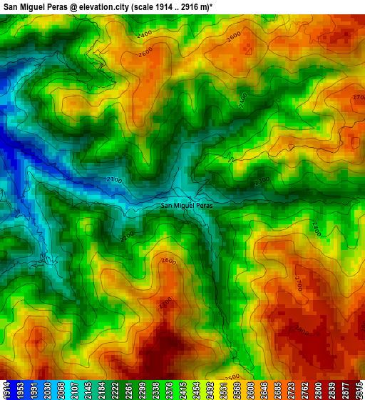
Below is the Elevation map of San Miguel Peras, which displays elevation range with different colors. Scale of the first map is from 1914 to 2916 m (6280 to 9567 ft) with average elevation of 2426.2 meters (=7960 ft) [note 1]
These maps also provides idea of topography and contour of this city, they are displayed at different zoom levels. More info about maps, scale and edge coordinates you can find below images.
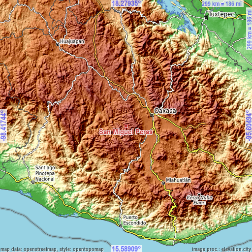
| \ | Map #1 | Topo.Map |
| Scale [m] | 1914..2916 m | × |
| Scale [ft] | 6280..9567 ft | × |
| Average | 2426.2 m = 7960 ft | × |
| Width | 9.35 km = 5.8 mi | 299.1 km = 185.9 mi |
| Height | 9.35 km = 5.8 mi | 299.2 km = 185.9 mi |
| ↑Max Latitude | 16.981064° | 18.27935° |
| Latitude at center | 16.93903° | 16.93903° |
| ↓Min Latitude | 16.896987° | 15.58909° |
| ← Min Longitude | -97.055135° | -98.41744° |
| Longitude center | -97.01119° | -97.01119° |
| →Max Longitude | -96.967245° | -95.60494° |
Nearby cities:
Cities around San Miguel Peras sort by population:
• Cuilapan de Guerrero elevation 1558 m
24.9 km,  80°
80°
• San Pedro Ixtlahuaca 1644 m
24.7 km,  55°
55°
• San Bernardo Mixtepec 1651 m
17.3 km,  136°
136°
• San Antonio Huitepec 2343 m
14.5 km,  265°
265°
• Santa Cruz Mixtepec 1595 m
21.4 km, 139°
• Santiago Huaxolotipac 1804 m
8.9 km,  295°
295°
• Santa María Lachixío 2251 m
23.6 km,  181°
181°
• San Andrés Ixtlahuaca 1643 m
24.5 km,  53°
53°
• San Miguel Mixtepec 1978 m
18.9 km,  162°
162°
• Santa Inés del Monte 2426 m
15.9 km,  96°
96°
• Magdalena Mixtepec 2019 m
12.1 km,  112°
112°
• San Pablo Cuatro Venados 2491 m
13.6 km,  69°
69°
Multilingual:
 En español:
San Miguel Peras elevación 2086 m.
 En France:
San Miguel Peras élévation 2086 m.
 Auf Deutsch:
San Miguel Peras höhe über dem Meeresspiegel ist 2086 m.

Sources and notes:
- [note 1] Map square and city borders are not equal. Map elevation data is calculated only from area inside that square.
- [src 1] Elevation data from geonames database provided with same terms of usage.
- [src 2] The elevation map of San Miguel Peras is generated using elevation data from NASA's 3 arcsec (90m) resolution SRTM data.
- [src 3] Base (background) map © OpenStreetMap contributors tiles are generated by Geofabrik and OpenTopoMap.
Copyright & License:
This San Miguel Peras Elevation Map is licensed under CC BY-SA. You may reuse any part from this page, if you give a proper credit by linking to this URL:
 More info on terms of use page.