La Luz elevation
La Luz (Oaxaca, Villa de Tututepec de Melchor Ocampo), Mexico elevation is 57 meters and La Luz elevation in feet is 187 ft above sea level [src 1]. La Luz is a populated place (feature code) with elevation that is 1257 meters (4124 ft) smaller than average city elevation in Mexico.
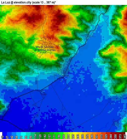
Below is the Elevation map of La Luz, which displays elevation range with different colors. Scale of the first map is from 13 to 387 m (43 to 1270 ft) with average elevation of 115.2 meters (=378 ft) [note 1]
These maps also provides idea of topography and contour of this city, they are displayed at different zoom levels. More info about maps, scale and edge coordinates you can find below images.
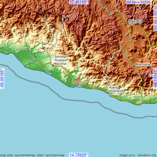
| \ | Map #1 | Topo.Map |
| Scale [m] | 13..387 m | × |
| Scale [ft] | 43..1270 ft | × |
| Average | 115.2 m = 378 ft | × |
| Width | 9.39 km = 5.8 mi | 300.4 km = 186.7 mi |
| Height | 9.39 km = 5.8 mi | 300.4 km = 186.7 mi |
| ↑Max Latitude | 16.156984° | 17.46105° |
| Latitude at center | 16.11477° | 16.11477° |
| ↓Min Latitude | 16.072547° | 14.75929° |
| ← Min Longitude | -97.639645° | -99.00195° |
| Longitude center | -97.5957° | -97.5957° |
| →Max Longitude | -97.551755° | -96.18945° |
Nearby cities:
Cities around La Luz sort by population:
• Río Grande elevation 26 m
20.6 km,  124°
124°
• Jamiltepec 461 m
30.7 km,  307°
307°
• Santa Catarina Juquila 1441 m
35.3 km,  67°
67°
• San Miguel Panixtlahuaca 800 m
28.4 km,  55°
55°
• San José del Progreso 23 m
10.8 km,  258°
258°
• Tepenixtlahuaca 461 m
22.6 km,  29°
29°
• Tataltepec de Valdés 382 m
21.9 km,  14°
14°
• Santa Rosa de Lima 22 m
5.7 km,  211°
211°
• Santiago Jocotepec 657 m
17 km,  84°
84°
• Santiago Tetepec 271 m
28.2 km,  324°
324°
• Santa María Acatepec 730 m
9.6 km, 67°
• San Marcos Zacatepec 799 m
25.7 km, 82°
Multilingual:
 En español:
La Luz elevación 57 m.
 En France:
La Luz élévation 57 m.


Sources and notes:
- [note 1] Map square and city borders are not equal. Map elevation data is calculated only from area inside that square.
- [src 1] Elevation data from geonames database provided with same terms of usage.
- [src 2] The elevation map of La Luz is generated using elevation data from NASA's 3 arcsec (90m) resolution SRTM data.
- [src 3] Base (background) map © OpenStreetMap contributors tiles are generated by Geofabrik and OpenTopoMap.
Copyright & License:
This La Luz Elevation Map is licensed under CC BY-SA. You may reuse any part from this page, if you give a proper credit by linking to this URL:
 More info on terms of use page.