Jamiltepec elevation
Jamiltepec (Oaxaca, Santiago Jamiltepec), Mexico elevation is 461 meters and Jamiltepec elevation in feet is 1512 ft above sea level [src 1]. Jamiltepec is a seat of a second-order administrative division (feature code) with elevation that is 853 meters (2799 ft) smaller than average city elevation in Mexico.
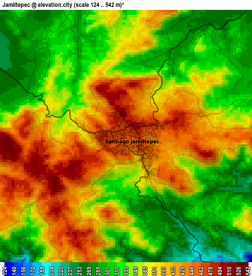
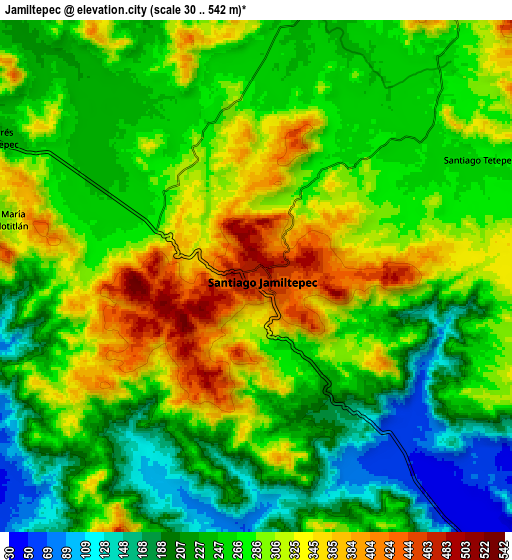
Below is the Elevation map of Jamiltepec, which displays elevation range with different colors. Scale of the first map is from 124 to 542 m (407 to 1778 ft) with average elevation of 359.9 meters (=1181 ft) [note 1]
These maps also provides idea of topography and contour of this city, they are displayed at different zoom levels. More info about maps, scale and edge coordinates you can find below images.
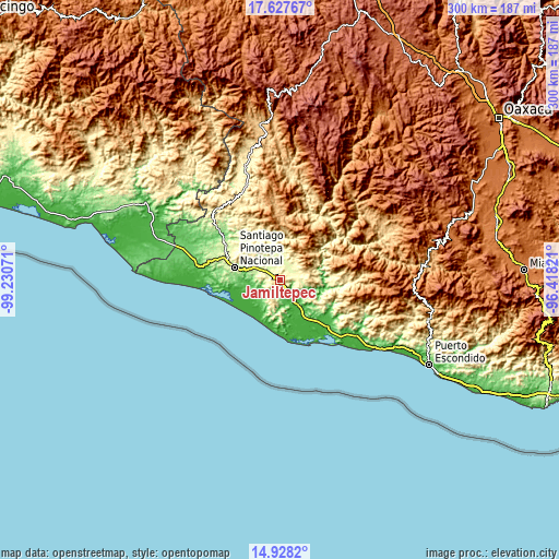
| \ | Map #1 | Map #2 | Topo.Map |
| Scale [m] | 124..542 m | 30..542 m | × |
| Scale [ft] | 407..1778 ft | 98..1778 ft | × |
| Average | 359.9 m = 1181 ft | 269.4 m = 884 ft | × |
| Width | 9.38 km = 5.8 mi | 18.76 km = 11.7 mi | 300.2 km = 186.5 mi |
| Height | 9.38 km = 5.8 mi | 18.76 km = 11.7 mi | 300.2 km = 186.5 mi |
| ↑Max Latitude | 16.324758° | 16.366927° | 17.62767° |
| Latitude at center | 16.28258° | 16.28258° | 16.28258° |
| ↓Min Latitude | 16.240393° | 16.198197° | 14.9282° |
| ← Min Longitude | -97.868405° | -97.912351° | -99.23071° |
| Longitude center | -97.82446° | -97.82446° | -97.82446° |
| →Max Longitude | -97.780515° | -97.736569° | -96.41821° |
Nearby cities:
Cities around Jamiltepec sort by population:
• Santa María Huazolotitlán elevation 286 m
9.7 km,  283°
283°
• Santa Catarina Mechoacán 284 m
6.1 km,  347°
347°
• San Andrés Huaxpaltepec 233 m
11.1 km,  297°
297°
• José María Morelos 32 m
14.3 km,  232°
232°
• Collantes 18 m
18.9 km,  236°
236°
• San Lorenzo 240 m
13.6 km,  337°
337°
• San Agustín Chayuco 259 m
13.4 km,  7°
7°
• San Miguel Tetepelcingo 230 m
15.2 km,  327°
327°
• El Carrizo 83 m
22.2 km,  261°
261°
• Santa María Chico Ometepec 19 m
19.3 km, 231°
• Santiago Tetepec 271 m
9.3 km,  61°
61°
• Rancho Viejo 232 m
16.2 km,  293°
293°
Multilingual:
 En español:
Jamiltepec elevación 461 m.
 En France:
Jamiltepec élévation 461 m.
 Auf Deutsch:
Jamiltepec höhe über dem Meeresspiegel ist 461 m.

Sources and notes:
- [note 1] Map square and city borders are not equal. Map elevation data is calculated only from area inside that square.
- [src 1] Elevation data from geonames database provided with same terms of usage.
- [src 2] The elevation map of Jamiltepec is generated using elevation data from NASA's 3 arcsec (90m) resolution SRTM data.
- [src 3] Base (background) map © OpenStreetMap contributors tiles are generated by Geofabrik and OpenTopoMap.
Copyright & License:
This Jamiltepec Elevation Map is licensed under CC BY-SA. You may reuse any part from this page, if you give a proper credit by linking to this URL:
 More info on terms of use page.