San Miguel Panixtlahuaca elevation
San Miguel Panixtlahuaca (Oaxaca), Mexico elevation is 800 meters and San Miguel Panixtlahuaca elevation in feet is 2625 ft above sea level [src 1]. San Miguel Panixtlahuaca is a populated place (feature code) with elevation that is 514 meters (1686 ft) smaller than average city elevation in Mexico.
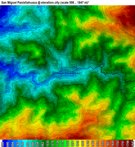
Below is the Elevation map of San Miguel Panixtlahuaca, which displays elevation range with different colors. Scale of the first map is from 598 to 1847 m (1962 to 6060 ft) with average elevation of 1109.9 meters (=3641 ft) [note 1]
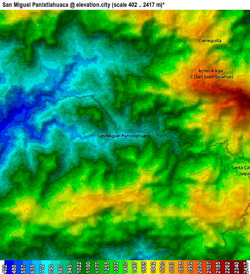
These maps also provides idea of topography and contour of this city, they are displayed at different zoom levels. More info about maps, scale and edge coordinates you can find below images.
| \ | Map #1 | Map #2 | Topo.Map |
| Scale [m] | 598..1847 m | 402..2417 m | × |
| Scale [ft] | 1962..6060 ft | 1319..7930 ft | × |
| Average | 1109.9 m = 3641 ft | 1225.1 m = 4019 ft | × |
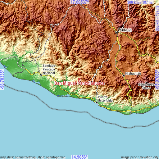
| Width | 9.38 km = 5.8 mi | 18.76 km = 11.7 mi | 300.2 km = 186.5 mi |
| Height | 9.38 km = 5.8 mi | 18.76 km = 11.7 mi | 300.2 km = 186.5 mi |
| ↑Max Latitude | 16.302303° | 16.344477° | 17.60537° |
| Latitude at center | 16.26012° | 16.26012° | 16.26012° |
| ↓Min Latitude | 16.217928° | 16.175727° | 14.9056° |
| ← Min Longitude | -97.421045° | -97.464991° | -98.78335° |
| Longitude center | -97.3771° | -97.3771° | -97.3771° |
| →Max Longitude | -97.333155° | -97.289209° | -95.97085° |
Nearby cities:
Cities around San Miguel Panixtlahuaca sort by population:
• Santa Catarina Juquila elevation 1441 m
9.4 km,  104°
104°
• Santiago Yaitepec 1783 m
12.1 km,  108°
108°
• Tepenixtlahuaca 461 m
12.8 km,  286°
286°
• Tataltepec de Valdés 382 m
18.7 km, 285°
• San Juan Quiahue 1939 m
7.9 km,  53°
53°
• Santa Lucía Teotepec 1195 m
22.2 km,  126°
126°
• Santiago Jocotepec 657 m
16 km,  203°
203°
• Cerro del Aire 601 m
24.9 km, 132°
• Santa María Temaxcaltepec 1324 m
21.9 km,  118°
118°
• Cieneguilla 1620 m
9.5 km,  41°
41°
• Santa María Acatepec 730 m
19.1 km,  229°
229°
• San Marcos Zacatepec 799 m
13.1 km,  170°
170°
Multilingual:
 En español:
San Miguel Panixtlahuaca elevación 800 m.
 En France:
San Miguel Panixtlahuaca élévation 800 m.
 Auf Deutsch:
San Miguel Panixtlahuaca höhe über dem Meeresspiegel ist 800 m.
 На русском:
San Miguel Panixtlahuaca высота над уровнем моря 800 м
Sources and notes:
- [note 1] Map square and city borders are not equal. Map elevation data is calculated only from area inside that square.
- [src 1] Elevation data from geonames database provided with same terms of usage.
- [src 2] The elevation map of San Miguel Panixtlahuaca is generated using elevation data from NASA's 3 arcsec (90m) resolution SRTM data.
- [src 3] Base (background) map © OpenStreetMap contributors tiles are generated by Geofabrik and OpenTopoMap.
Copyright & License:
This San Miguel Panixtlahuaca Elevation Map is licensed under CC BY-SA. You may reuse any part from this page, if you give a proper credit by linking to this URL:
 More info on terms of use page.