Río Grande elevation
Río Grande (Oaxaca, Villa de Tututepec de Melchor Ocampo), Mexico elevation is 26 meters and Río Grande elevation in feet is 85 ft above sea level [src 1]. Río Grande is a populated place (feature code) with elevation that is 1288 meters (4226 ft) smaller than average city elevation in Mexico.
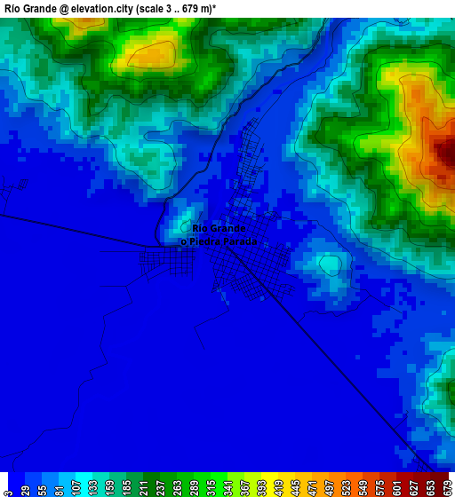
Below is the Elevation map of Río Grande, which displays elevation range with different colors. Scale of the first map is from 3 to 679 m (10 to 2228 ft) with average elevation of 92.1 meters (=302 ft) [note 1]
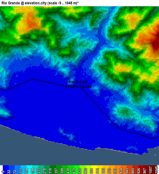
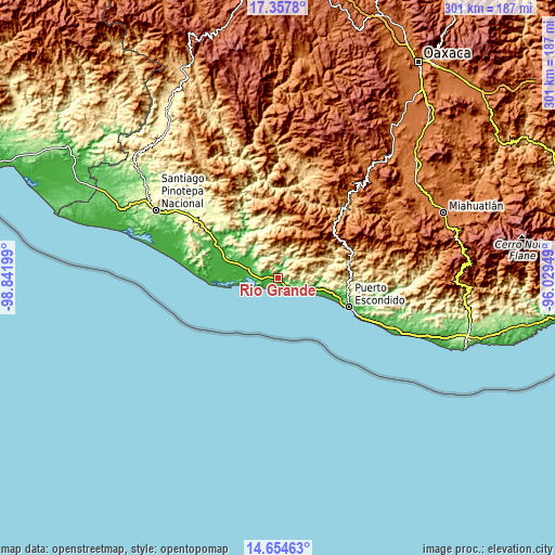
These maps also provides idea of topography and contour of this city, they are displayed at different zoom levels. More info about maps, scale and edge coordinates you can find below images.
| \ | Map #1 | Map #2 | Topo.Map |
| Scale [m] | 3..679 m | -9..1048 m | × |
| Scale [ft] | 10..2228 ft | -30..3438 ft | × |
| Average | 92.1 m = 302 ft | 202 m = 663 ft | × |
| Width | 9.39 km = 5.8 mi | 18.79 km = 11.7 mi | 300.6 km = 186.8 mi |
| Height | 9.39 km = 5.8 mi | 18.79 km = 11.7 mi | 300.6 km = 186.8 mi |
| ↑Max Latitude | 16.053026° | 16.095253° | 17.3578° |
| Latitude at center | 16.01079° | 16.01079° | 16.01079° |
| ↓Min Latitude | 15.968545° | 15.926291° | 14.65463° |
| ← Min Longitude | -97.479685° | -97.523631° | -98.84199° |
| Longitude center | -97.43574° | -97.43574° | -97.43574° |
| →Max Longitude | -97.391795° | -97.347849° | -96.02949° |
Nearby cities:
Cities around Río Grande sort by population:
• Santa Catarina Juquila elevation 1441 m
29.6 km,  31°
31°
• San Miguel Panixtlahuaca 800 m
28.4 km,  12°
12°
• San José del Progreso 23 m
29.2 km,  288°
288°
• La Luz 57 m
20.6 km,  304°
304°
• Santa Rosa de Lima 22 m
21.1 km, 288°
• Santa María Tiltepec 477 m
28.9 km,  78°
78°
• Santa Lucía Teotepec 1195 m
28.3 km,  58°
58°
• Santiago Jocotepec 657 m
13.1 km,  359°
359°
• Cerro del Aire 601 m
27.1 km,  65°
65°
• Santiago Cuixtla 437 m
27.3 km, 77°
• Santa María Acatepec 730 m
17.4 km,  331°
331°
• San Marcos Zacatepec 799 m
17 km, 29°
Multilingual:
 En español:
Río Grande elevación 26 m.
 En France:
Río Grande élévation 26 m.
 Auf Deutsch:
Río Grande höhe über dem Meeresspiegel ist 26 m.

Sources and notes:
- [note 1] Map square and city borders are not equal. Map elevation data is calculated only from area inside that square.
- [src 1] Elevation data from geonames database provided with same terms of usage.
- [src 2] The elevation map of Río Grande is generated using elevation data from NASA's 3 arcsec (90m) resolution SRTM data.
- [src 3] Base (background) map © OpenStreetMap contributors tiles are generated by Geofabrik and OpenTopoMap.
Copyright & License:
This Río Grande Elevation Map is licensed under CC BY-SA. You may reuse any part from this page, if you give a proper credit by linking to this URL:
 More info on terms of use page.