Chumatlán elevation
Chumatlán (Veracruz), Mexico elevation is 399 meters and Chumatlán elevation in feet is 1309 ft above sea level [src 1]. Chumatlán is a seat of a second-order administrative division (feature code) with elevation that is 915 meters (3002 ft) smaller than average city elevation in Mexico.
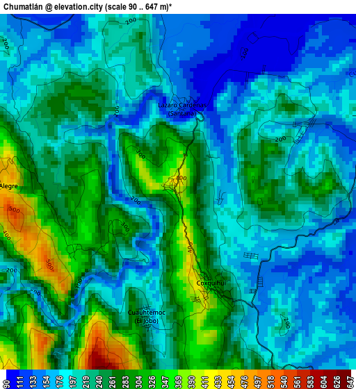
Below is the Elevation map of Chumatlán, which displays elevation range with different colors. Scale of the first map is from 90 to 647 m (295 to 2123 ft) with average elevation of 227.4 meters (=746 ft) [note 1]
These maps also provides idea of topography and contour of this city, they are displayed at different zoom levels. More info about maps, scale and edge coordinates you can find below images.
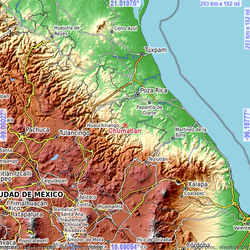
| \ | Map #1 | Topo.Map |
| Scale [m] | 90..647 m | × |
| Scale [ft] | 295..2123 ft | × |
| Average | 227.4 m = 746 ft | × |
| Width | 9.17 km = 5.7 mi | 293.5 km = 182.4 mi |
| Height | 9.17 km = 5.7 mi | 293.5 km = 182.4 mi |
| ↑Max Latitude | 20.246975° | 21.51975° |
| Latitude at center | 20.20574° | 20.20574° |
| ↓Min Latitude | 20.164494° | 18.88054° |
| ← Min Longitude | -97.637965° | -99.00027° |
| Longitude center | -97.59402° | -97.59402° |
| →Max Longitude | -97.550075° | -96.18777° |
Nearby cities:
Cities around Chumatlán sort by population:
• Coyutla elevation 161 m
8.1 km,  304°
304°
• Coxquihui 287 m
2.6 km,  160°
160°
• Zozocolco de Hidalgo 298 m
7.5 km,  165°
165°
• Xonalpu 696 m
8.8 km,  191°
191°
• Las Lomas 145 m
6.5 km,  340°
340°
• Ricardo Flores Magón 335 m
3.1 km,  240°
240°
• Lázaro Cárdenas (Santana) 130 m
2.1 km,  2°
2°
• El Arenal 136 m
7 km, 1°
• Putlunichuchut (Vista Hermosa) 591 m
6 km,  202°
202°
• Santa Isabel 113 m
6.9 km,  102°
102°
• Sabanas de Xalostoc 103 m
6.4 km,  73°
73°
• Rancho Alegre 464 m
4.7 km,  272°
272°
Multilingual:
 En español:
Chumatlán elevación 399 m.
 En France:
Chumatlán élévation 399 m.
 Auf Deutsch:
Chumatlán höhe über dem Meeresspiegel ist 399 m.

Sources and notes:
- [note 1] Map square and city borders are not equal. Map elevation data is calculated only from area inside that square.
- [src 1] Elevation data from geonames database provided with same terms of usage.
- [src 2] The elevation map of Chumatlán is generated using elevation data from NASA's 3 arcsec (90m) resolution SRTM data.
- [src 3] Base (background) map © OpenStreetMap contributors tiles are generated by Geofabrik and OpenTopoMap.
Copyright & License:
This Chumatlán Elevation Map is licensed under CC BY-SA. You may reuse any part from this page, if you give a proper credit by linking to this URL:
 More info on terms of use page.