Xonalpu elevation
Xonalpu (Puebla, Huehuetla), Mexico elevation is 696 meters and Xonalpu elevation in feet is 2283 ft above sea level [src 1]. Xonalpu is a populated place (feature code) with elevation that is 618 meters (2028 ft) smaller than average city elevation in Mexico.
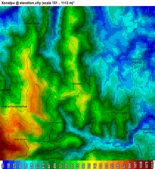
Below is the Elevation map of Xonalpu, which displays elevation range with different colors. Scale of the first map is from 151 to 1112 m (495 to 3648 ft) with average elevation of 465.2 meters (=1526 ft) [note 1]
These maps also provides idea of topography and contour of this city, they are displayed at different zoom levels. More info about maps, scale and edge coordinates you can find below images.
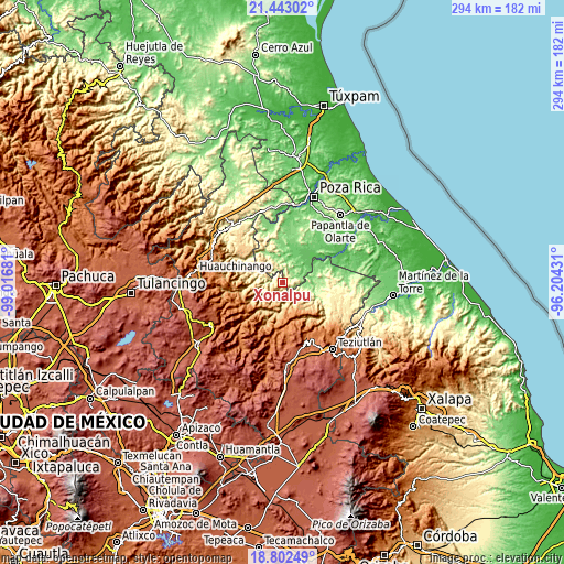
| \ | Map #1 | Topo.Map |
| Scale [m] | 151..1112 m | × |
| Scale [ft] | 495..3648 ft | × |
| Average | 465.2 m = 1526 ft | × |
| Width | 9.18 km = 5.7 mi | 293.6 km = 182.4 mi |
| Height | 9.18 km = 5.7 mi | 293.6 km = 182.4 mi |
| ↑Max Latitude | 20.169586° | 21.44302° |
| Latitude at center | 20.12833° | 20.12833° |
| ↓Min Latitude | 20.087063° | 18.80249° |
| ← Min Longitude | -97.654505° | -99.01681° |
| Longitude center | -97.61056° | -97.61056° |
| →Max Longitude | -97.566615° | -96.20431° |
Nearby cities:
Cities around Xonalpu sort by population:
• Coxquihui elevation 287 m
6.7 km,  22°
22°
• Caxhuacán 700 m
7.2 km,  176°
176°
• Zozocolco de Hidalgo 298 m
3.9 km,  69°
69°
• Leacaman 787 m
4.7 km,  225°
225°
• Cinco de Mayo 616 m
2.1 km,  280°
280°
• Zozocolco de Guerrero 263 m
5.1 km,  122°
122°
• Huehuetla 545 m
2.9 km,  211°
211°
• Ricardo Flores Magón 335 m
7.2 km,  352°
352°
• Vicente Guerrero 526 m
4.6 km,  262°
262°
• Lipuntahuaca 465 m
4.6 km, 206°
• Putlunichuchut (Vista Hermosa) 591 m
3.1 km, 350°
• Lacapan Camallagne 535 m
4.5 km,  270°
270°
Multilingual:
 En español:
Xonalpu elevación 696 m.
 En France:
Xonalpu élévation 696 m.


Sources and notes:
- [note 1] Map square and city borders are not equal. Map elevation data is calculated only from area inside that square.
- [src 1] Elevation data from geonames database provided with same terms of usage.
- [src 2] The elevation map of Xonalpu is generated using elevation data from NASA's 3 arcsec (90m) resolution SRTM data.
- [src 3] Base (background) map © OpenStreetMap contributors tiles are generated by Geofabrik and OpenTopoMap.
Copyright & License:
This Xonalpu Elevation Map is licensed under CC BY-SA. You may reuse any part from this page, if you give a proper credit by linking to this URL:
 More info on terms of use page.